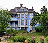
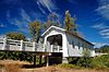
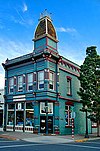
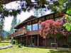
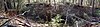
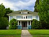
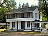
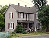
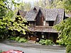
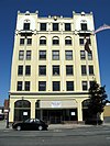
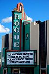
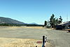
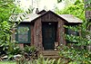
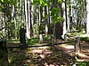
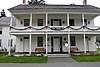
[5] Name on the Register Image Date listed [6] Location City or town Description 1 John and Susanna Ahlf House John and Susanna Ahlf House May 9, 1983 (# 83002154 762 NW 6th St. 42°26′44″N 123°19′26″W / 42.445578°N 123.323789°W / 42.445578; -123.323789 (John and Susanna Ahlf House ) Grants Pass Built in 1902, this is the finest remaining example of the Queen Anne style in Grants Pass, and was the most prominent home in the city prior to World War I . It was built for John Ahlf (1856–1932), a German immigrant and meat packer who became one of the leading businessmen of the Rogue Valley . [7] 2 Allen Gulch Mill Upload image October 4, 2001 (# 01001148 approx. 1 mi. SE of Jct. of Waldo Rd. and Waldo Lookout Rd. 42°03′00″N 123°38′16″W / 42.05°N 123.637778°W / 42.05; -123.637778 (Allen Gulch Mill ) Cave Junction vicinity 3 Allen Gulch Townsite Upload image October 4, 2001 (# 01001136 Approx. 1 mi. SE. of Jct. of Waldo Rd. and Waldo Lookout Rd. 42°02′50″N 123°37′55″W / 42.047222°N 123.631944°W / 42.047222; -123.631944 (Allen Gulch Townsite ) Cave Junction vicinity 4 George Calhoun House George Calhoun House December 2, 1981 (# 81000495 612 NW 5th St. 42°26′38″N 123°19′34″W / 42.44386667°N 123.3260528°W / 42.44386667; -123.3260528 (George Calhoun House ) Grants Pass 5 Cameron Mine Upload image October 4, 2001 (# 01001144 Approx. 2 mi. S. of Jct. of Waldo Rd. and Waldo Lookout Rd. 42°02′29″N 123°38′15″W / 42.041389°N 123.6375°W / 42.041389; -123.6375 (Cameron Mine ) Cave Junction vicinity 6 Cedar Guard Station No. 1019 Cedar Guard Station No. 1019 April 8, 1986 (# 86000837 Oregon Route 46 , Rogue River – Siskiyou National Forest 42°08′26″N 123°27′24″W / 42.140526°N 123.456804°W / 42.140526; -123.456804 (Cedar Guard Station No. 1019 ) Cave Junction 7 Clark–McConnell House Clark–McConnell House June 3, 1998 (# 98000628 961 SE 8th St. 42°25′52″N 123°19′43″W / 42.43102778°N 123.3285778°W / 42.43102778; -123.3285778 (Clark–McConnell House ) Grants Pass 8 Clark–Norton House Clark–Norton House February 27, 1986 (# 86000290 127 NW D St. 42°26′29″N 123°19′36″W / 42.44148889°N 123.3265333°W / 42.44148889; -123.3265333 (Clark–Norton House ) Grants Pass 9 Michael Clemens House Michael Clemens House April 29, 1982 (# 82003728 612 NW 3rd St. 42°26′41″N 123°19′43″W / 42.44466667°N 123.3285361°W / 42.44466667; -123.3285361 (Michael Clemens House ) Grants Pass 10 Albert B. and Mary Cornell House Albert B. and Mary Cornell House October 31, 2002 (# 02001279 121 NE B St. 42°26′33″N 123°19′28″W / 42.442520°N 123.324396°W / 42.442520; -123.324396 (Albert B. and Mary Cornell House ) Grants Pass 11 Thomas Croxton House Thomas Croxton House March 29, 1979 (# 79002076 1002 NW Washington Blvd. 42°26′53″N 123°19′32″W / 42.44803056°N 123.3255333°W / 42.44803056; -123.3255333 (Thomas Croxton House ) Grants Pass 12 Deep Gravel Mine Upload image October 4, 2001 (# 01001141 Approx. 1 mile (1.6 km) north of the junction of Waldo Rd. and BLM Rd. 40-8-28 42°04′07″N 123°38′43″W / 42.068559°N 123.645331°W / 42.068559; -123.645331 (Deep Gravel Mine ) Cave Junction vicinity 13 Dimmick–Judson House Dimmick–Judson House June 3, 1998 (# 98000629 906 NE 8th St. 42°26′47″N 123°19′13″W / 42.44634722°N 123.3202333°W / 42.44634722; -123.3202333 (Dimmick–Judson House ) Grants Pass 14 Esterly Pit #2 / Llano de Oro Mine Upload image October 4, 2001 (# 01001145 Approx. 1.5 miles (2.4 km) north of the junction of Waldo Rd. and BLM Rd. 40-8-28 42°04′24″N 123°38′16″W / 42.073288°N 123.637756°W / 42.073288; -123.637756 (Esterly Pit #2 / Llano de Oro Mine ) Cave Junction vicinity 15 Joseph Fetzner House Joseph Fetzner House October 25, 1990 (# 90001595 314 NE. Fetzner St. 42°26′49″N 123°19′08″W / 42.44696944°N 123.3189028°W / 42.44696944; -123.3189028 (Joseph Fetzner House ) Grants Pass 16 Dr. William H. Flanagan House Dr. William H. Flanagan House May 9, 1983 (# 83002155 720 NW 6th St. 42°26′40″N 123°19′27″W / 42.44436667°N 123.3242639°W / 42.44436667; -123.3242639 (Dr. William H. Flanagan House ) Grants Pass 17 Fry Gulch Mine Fry Gulch Mine October 4, 2001 (# 01001143 Approx. 0.75 miles (1.21 km) from the junction of Waldo Rd. and BLM Rd. 40-8-28 42°03′06″N 123°39′10″W / 42.051667°N 123.652778°W / 42.051667; -123.652778 (Fry Gulch Mine ) Cave Junction vicinity 18 Golden Historic District Golden Historic District July 25, 2002 (# 02000825 3482 Coyote Creek Rd. 42°40′55″N 123°20′09″W / 42.681944°N 123.335833°W / 42.681944; -123.335833 (Golden Historic District ) Wolf Creek 19 Grants Pass City Hall and Fire Station Grants Pass City Hall and Fire Station September 7, 1984 (# 84003017 4th and H Sts. 42°26′21″N 123°19′48″W / 42.43928056°N 123.3301361°W / 42.43928056; -123.3301361 (Grants Pass City Hall and Fire Station ) Grants Pass 20 Grants Pass G Street Historic District Grants Pass G Street Historic District October 7, 1993 (# 93001030 Bounded by SW G and H Sts. and 4th and 6th Sts. 42°26′20″N 123°19′43″W / 42.43901111°N 123.3286056°W / 42.43901111; -123.3286056 (Grants Pass G Street Historic District ) Grants Pass 21 Grants Pass Supervisor's Warehouse Grants Pass Supervisor's Warehouse March 6, 1991 (# 91000163 1012 SW L St. 42°26′14″N 123°20′20″W / 42.437167°N 123.338897°W / 42.437167; -123.338897 (Grants Pass Supervisor's Warehouse ) Grants Pass 22 Grave Creek Bridge Grave Creek Bridge November 29, 1979 (# 79002077 N of Grants Pass 42°38′10″N 123°22′39″W / 42.63611111°N 123.3775833°W / 42.63611111; -123.3775833 (Grave Creek Bridge ) Sunny Valley 23 High Gravel Mine High Gravel Mine October 4, 2001 (# 01001142 Approx. 1.3 miles (2.1 km) south of the junction of Waldo Rd. and Waldo Lookout Rd. 42°02′54″N 123°38′37″W / 42.048331°N 123.643531°W / 42.048331; -123.643531 (High Gravel Mine ) Cave Junction vicinity 24 Hotel Josephine Annex Hotel Josephine Annex February 21, 1997 (# 97000133 118 NW E St. 42°26′28″N 123°19′36″W / 42.44113611°N 123.3266556°W / 42.44113611; -123.3266556 (Hotel Josephine Annex ) Grants Pass 25 Hugo Community Baptist Church Hugo Community Baptist Church October 25, 1990 (# 90001587 6501 Hugo Rd. 42°35′05″N 123°24′07″W / 42.584633°N 123.401911°W / 42.584633; -123.401911 (Hugo Community Baptist Church ) Grants Pass vicinity 26 Kienlen–Harbeck Building Kienlen–Harbeck Building May 13, 1982 (# 82003729 147 SW G St. 42°26′21″N 123°19′42″W / 42.4391°N 123.3283444°W / 42.4391; -123.3283444 (Kienlen–Harbeck Building ) Grants Pass 27 William J. and Sarah Wagner Lippincott House William J. and Sarah Wagner Lippincott House May 18, 2015 (# 15000239 14601 Watergap Road 42°16′26″N 123°15′41″W / 42.273973°N 123.261324°W / 42.273973; -123.261324 (William J. and Sarah Wagner Lippincott House ) Williams vicinity 28 Logan Cut Upload image October 4, 2001 (# 01001154 Historic channel of Logan Cut 42°06′17″N 123°38′30″W / 42.104724°N 123.641660°W / 42.104724; -123.641660 (Logan Cut ) Cave Junction vicinity 29 Logan Drain Ditches Logan Drain Ditches October 4, 2001 (# 01001155 Approx. 2 miles (3.2 km) north of the junction of Waldo Rd. and BLM Rd. 40-8-28 42°04′48″N 123°37′43″W / 42.080052°N 123.628556°W / 42.080052; -123.628556 (Logan Drain Ditches ) Cave Junction vicinity 30 Logan Wash Ditch Logan Wash Ditch October 4, 2001 (# 01001153 Historic Channel of Logan Wash Ditch 42°04′02″N 123°37′06″W / 42.067222°N 123.618333°W / 42.067222; -123.618333 (Logan Wash Ditch ) Cave Junction vicinity 31 George H. Lundburg House George H. Lundburg House March 6, 1987 (# 87000365 404 NW A St. 42°26′42″N 123°19′42″W / 42.44513333°N 123.3282639°W / 42.44513333; -123.3282639 (George H. Lundburg House ) Grants Pass 32 Robert and Lucy McLean House Robert and Lucy McLean House April 5, 1984 (# 84003020 724 NW 4th St. 42°26′43″N 123°19′36″W / 42.44536389°N 123.32665°W / 42.44536389; -123.32665 (Robert and Lucy McLean House ) Grants Pass 33 Middle Ditch Middle Ditch October 4, 2001 (# 01001150 Historic channel of the Logan/Esterly Middle Ditch 42°03′53″N 123°37′53″W / 42.064722°N 123.631389°W / 42.064722; -123.631389 (Middle Ditch ) Cave Junction vicinity 34 William and Nannie Naucke House William and Nannie Naucke House August 5, 1999 (# 99000946 24195 Redwood Highway 42°11′50″N 123°39′02″W / 42.197325°N 123.6504194°W / 42.197325; -123.6504194 (William and Nannie Naucke House ) Kerby 35 Edwin Newell House Edwin Newell House November 15, 1979 (# 79002078 591 SW G St. 42°26′25″N 123°20′05″W / 42.44024722°N 123.3347528°W / 42.44024722; -123.3347528 (Edwin Newell House ) Grants Pass 36 Newman United Methodist Church Newman United Methodist Church December 23, 1977 (# 77001103 128 NE B St. 42°26′35″N 123°19′28″W / 42.44294444°N 123.3243361°W / 42.44294444; -123.3243361 (Newman United Methodist Church ) Grants Pass 37 Old Placer Mine Upload image October 4, 2001 (# 01001140 Approximately .65 miles (1.05 km) west of the junction of Rockydale Road and BLM Road 40-8-15 42°05′35″N 123°38′02″W / 42.092937°N 123.633988°W / 42.092937; -123.633988 (Old Placer Mine ) Cave Junction vicinity 38 Oregon Caves Chateau Oregon Caves Chateau May 28, 1987 (# 87001346 Oregon Caves National Monument , 19000 Caves Highway 42°05′58″N 123°24′27″W / 42.099444°N 123.4075°W / 42.099444; -123.4075 (Oregon Caves Chateau ) Cave Junction vicinity 39 Oregon Caves Historic District Oregon Caves Historic District February 25, 1992 (# 92000058 Oregon Caves National Monument and Preserve , 19000 Caves Highway 42°05′58″N 123°24′25″W / 42.099444°N 123.406944°W / 42.099444; -123.406944 (Oregon Caves Historic District ) Cave Junction vicinity 40 Osgood Ditch Osgood Ditch October 4, 2001 (# 01001151 Historic channel of Osgood Ditch (See also Del Norte County, California .) 42°02′31″N 123°38′17″W / 42.041898°N 123.637951°W / 42.041898; -123.637951 (Osgood Ditch ) Cave Junction vicinity 41 Plataurica Mine Upload image October 4, 2001 (# 01001146 Approx. .75 mi. SE. of Jct. of Waldo Rd. and Waldo Lookout Rd. 42°03′10″N 123°38′07″W / 42.0528°N 123.6353°W / 42.0528; -123.6353 (Plataurica Mine ) Cave Junction vicinity 42 Rand Ranger Station Rand Ranger Station June 10, 1999 (# 99000703 14335 Galice Rd. 42°35′53″N 123°34′59″W / 42.5981°N 123.5831°W / 42.5981; -123.5831 (Rand Ranger Station ) Merlin 43 Redwoods Hotel Redwoods Hotel October 25, 1979 (# 79002079 310 NW 6th St 42°26′28″N 123°19′34″W / 42.441072°N 123.32609°W / 42.441072; -123.32609 (Redwoods Hotel ) Grants Pass 44 Reed–Cobb–Bowser House and Barn Reed–Cobb–Bowser House and Barn October 30, 2017 (# 100001772 1700 Merlin Rd. 42°30′19″N 123°23′52″W / 42.5054°N 123.3979°W / 42.5054; -123.3979 (Reed–Cobb–Bowser House and Barn ) Merlin 45 Riverside Park Riverside Park October 23, 2020 (# 100005722 304 SE Park St. 42°25′45″N 123°19′42″W / 42.4291°N 123.3284°W / 42.4291; -123.3284 (Riverside Park ) Grants Pass 46 Rogue River Valley Grange No. 469 Upload image March 9, 1992 (# 92000130 2064 Upper River Rd. 42°26′27″N 123°21′09″W / 42.440822°N 123.35246°W / 42.440822; -123.35246 (Rogue River Valley Grange No. 469 ) Grants Pass Destroyed by fire in June 2012. [8] [9] 47 Rogue Theatre Rogue Theatre June 30, 2005 (# 05000640 143 SE H St. 42°26′16″N 123°19′36″W / 42.437722°N 123.32655°W / 42.437722; -123.32655 (Rogue Theatre ) Grants Pass 48 St. Patrick's Roman Catholic Cemetery St. Patrick's Roman Catholic Cemetery October 4, 2001 (# 01001137 Approx. 1 mile (1.6 km) southeast of the junction of Waldo Rd. and Waldo Lookout Rd. 42°03′05″N 123°38′09″W / 42.0514°N 123.6358°W / 42.0514; -123.6358 (St. Patrick's Roman Catholic Cemetery ) Cave Junction vicinity 49 Claus and Hannchen Schmidt House Claus and Hannchen Schmidt House January 21, 2004 (# 03001478 508 SW 5th St. 42°26′14″N 123°19′48″W / 42.437133°N 123.32994°W / 42.437133; -123.32994 (Claus and Hannchen Schmidt House ) Grants Pass 50 Siskiyou Smokejumper Base Siskiyou Smokejumper Base November 17, 2006 (# 06001035 Smokejumper Way 42°06′14″N 123°40′52″W / 42.1038°N 123.681°W / 42.1038; -123.681 (Siskiyou Smokejumper Base ) Cave Junction vicinity 51 Herbert and Katherine Smith House Herbert and Katherine Smith House May 9, 1983 (# 83002156 139 SW I St. 42°26′15″N 123°19′45″W / 42.437633°N 123.3291°W / 42.437633; -123.3291 (Herbert and Katherine Smith House ) Grants Pass 52 Speed's Place on the Rogue Upload image June 21, 1991 (# 91000808 11407 Merlin-Galice Rd. 42°33′53″N 123°35′55″W / 42.5647°N 123.5987°W / 42.5647; -123.5987 (Speed's Place on the Rogue ) Galice 53 Store Gulch Guard Station No. 1020 Store Gulch Guard Station No. 1020 April 8, 1986 (# 86000838 Illinois Valley Rd., Rogue River – Siskiyou National Forest 42°17′50″N 123°45′06″W / 42.2971°N 123.7516°W / 42.2971; -123.7516 (Store Gulch Guard Station No. 1020 ) Cave Junction 54 Upper Ditch Upload image October 4, 2001 (# 01001149 Historic channel of the Logan/Esterly Upper Ditch (See also Del Norte County, California .) 42°01′10″N 123°38′06″W / 42.0194°N 123.635°W / 42.0194; -123.635 (Upper Ditch ) Cave Junction vicinity This ditch , built in 1854 to supply water from the East Fork Illinois River to several hydraulic mines , quickly returned a large profit to its investors . The ditch supplied mines worked by its own owners, as well as providing water for sale to other nearby diggings. It continued in operation until 1942, when the last hydraulic mining operations in the upper Illinois Valley ceased. [10] 55 Amos E. Voorhies House Amos E. Voorhies House February 23, 1990 (# 90000282 421 NW B St. 42°26′39″N 123°19′47″W / 42.444197°N 123.32961°W / 42.444197; -123.32961 (Amos E. Voorhies House ) Grants Pass 56 Waldo Cemetery Waldo Cemetery October 4, 2001 (# 01001138 Approx. 0.5 miles (0.80 km) southwest of the junction of Waldo Rd. and BLM Rd. 40-8-28 42°03′28″N 123°39′14″W / 42.0578°N 123.6538°W / 42.0578; -123.6538 (Waldo Cemetery ) Cave Junction vicinity 57 Waldo Chinese Cemetery Waldo Chinese Cemetery October 4, 2001 (# 01001139 Approx. 0.5 miles (0.80 km) southwest of the junction of Waldo Rd. and BLM Rd. 40-8-28 42°03′28″N 123°39′11″W / 42.0577°N 123.6530°W / 42.0577; -123.6530 (Waldo Chinese Cemetery ) Cave Junction vicinity 58 Waldo Mine Waldo Mine October 4, 2001 (# 01001147 Southwest of the junction of Waldo Rd. and BLM Rd. 40-8-28 42°03′32″N 123°38′55″W / 42.0589°N 123.6486°W / 42.0589; -123.6486 (Waldo Mine ) Cave Junction vicinity 59 Whisky Creek Cabin Whisky Creek Cabin September 5, 1975 (# 75001584 10 mi. W of Wolf Creek at Rogue River 42°39′38″N 123°37′59″W / 42.6606°N 123.6331°W / 42.6606; -123.6331 (Whisky Creek Cabin ) Wolf Creek 60 Wimer Ditch Wimer Ditch October 4, 2001 (# 01001152 Historic Channel of Wimer Ditch 42°04′01″N 123°38′19″W / 42.0669°N 123.6386°W / 42.0669; -123.6386 (Wimer Ditch ) Cave Junction vicinity 61 Wolf Creek Tavern Wolf Creek Tavern September 22, 1972 (# 72001081 West side, Old Pacific Highway, OR 99, About .5 mi N of US 5 42°41′43″N 123°23′46″W / 42.695158°N 123.3960°W / 42.695158; -123.3960 (Wolf Creek Tavern ) Wolf Creek