
Josephine County is one of the 36 counties in the U.S. state of Oregon. As of the 2020 census, the population was 88,090. The county seat is Grants Pass. The county is named after Virginia Josephine Rollins (1834-1912), a settler who was the first white woman to live in the county's boundaries. Josephine County comprises the Grants Pass, OR Metropolitan Statistical Area, which is included in the Medford-Grants Pass, OR Combined Statistical Area.

Cave Junction is a city in Josephine County, Oregon, United States. As of the 2020 census, the city population was 1,995. Its motto is the "Gateway to the Oregon Caves", and the city got its name by virtue of its location at the junction of Redwood Highway and Caves Highway. Cave Junction is located in the Illinois Valley, where, starting in the 1850s, the non-native economy depended on gold mining. After World War II, timber became the main source of income for residents. As timber income has since declined, Cave Junction is attempting to compensate with tourism and as a haven for retirees. Tourists visit the Oregon Caves National Monument and Preserve, which includes the Oregon Caves Chateau, as well as the Out'n'About treehouse resort and the Great Cats World Park zoo.

Grants Pass is the county seat of Josephine County, Oregon, United States. The city is located on Interstate 5, northwest of Medford, along the Rogue River. The population is 39,674 according to 2021 census.

The Rogue River in southwestern Oregon in the United States flows about 215 miles (346 km) in a generally westward direction from the Cascade Range to the Pacific Ocean. Known for its salmon runs, whitewater rafting, and rugged scenery, it was one of the original eight rivers named in the Wild and Scenic Rivers Act of 1968. Beginning near Crater Lake, which occupies the caldera left by the explosive volcanic eruption and collapse of Mount Mazama, the river flows through the geologically young High Cascades and the older Western Cascades, another volcanic province. Further west, the river passes through multiple exotic terranes of the more ancient Klamath Mountains. In the Kalmiopsis Wilderness section of the Rogue basin are some of the world's best examples of rocks that form the Earth's mantle. Near the mouth of the river, the only dinosaur fragments ever discovered in Oregon were found in the Otter Point Formation, along the coast of Curry County.
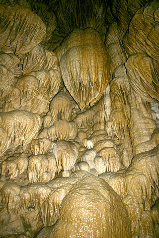
Oregon Caves National Monument and Preserve is a protected area in the northern Siskiyou Mountains of southwestern Oregon in the United States. The 4,554-acre (1,843 ha) park, including the marble cave, is 20 miles (32 km) east of Cave Junction, on Oregon Route 46. The protected area, managed by the National Park Service (NPS), is in southwestern Josephine County, near the Oregon–California border.

Champoeg is a former town in the U.S. state of Oregon. Now a ghost town, it was an important settlement in the Willamette Valley in the early 1840s. Located halfway between Oregon City and Salem, it was the site of the first provisional government of the Oregon Country.
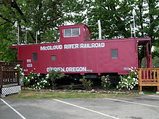
O'Brien is an unincorporated community and census-designated place (CDP) in Josephine County, Oregon, United States. As of the 2010 census, O'Brien had a population of 504. The unemployment rate is 6.9%, slightly higher than the national average of 5.2% The community was named after John O'Brien, who was one of the first settlers to arrive at the locality. In 2012, a small group started protecting the town when the police were cut due to budget cuts.
Takilma is an unincorporated community and census-designated place (CDP) in Josephine County, Oregon, United States, 10 miles (16 km) south of Cave Junction. It is located on the East Fork Illinois River, about a mile southeast of the ghost town of Waldo. As of the 2010 census, it had a population of 378.
William Waldo was a candidate for Governor of California in 1853. He was born in Harrison County, Virginia but spent most of his life in Missouri, where he was a merchant and steamboat captain. In 1849 he joined the gold rush to California at the head of a wagon train. In California the next year, reports arrived of impending starvation among numerous immigrants on the Nevada side of the Sierra Nevada mountains. Waldo put great effort into recruiting and delivering supplies for them, and became well known for his relief attempts. In 1853 the Whig party nominated Waldo as their candidate for Governor, but he narrowly lost to the incumbent John Bigler. Following his defeat, he returned east, first to Minnesota and then back to Missouri where his wife and children had remained. In his later years he moved to Texas, where he died.
Austin is an unincorporated community, considered a ghost town, in Grant County, Oregon, United States. It is located north of Oregon Route 7, near the Middle Fork John Day River in the Malheur National Forest.

Boyd was a town in Wasco County, Oregon, United States, disincorporated in 1955, and now vacant except for a few abandoned homes, weathered outbuildings, and a derelict wooden grain elevator surrounded by the wheat fields, which still produce the grain that used to fill it. The site was recently bought and turned into farmland. The site of the former settlement is 9.5 miles (15.3 km) southeast of The Dalles, on the east side of U.S. Route 197 from which it is visible at a distance.
Kerby is an unincorporated community and census-designated place (CDP) in Josephine County, Oregon, United States, north of Cave Junction on U.S. Route 199. As of the 2010 census the population was 595. Despite its population and numerous businesses, it is often listed in tourist guides as a ghost town, because of the number of historic buildings left from its days as a gold-mining town. Kerby came into existence between 1854 and 1857.

The following outline is provided as an overview of and topical guide to the U.S. state of Oregon:
Placer is an unincorporated community in Josephine County, Oregon, United States, on Grave Creek a few miles east of Interstate 5. Established during the local gold mining boom, it is considered a ghost town.

Robert Crouch Kinney was an American businessman and politician in what became the state of Oregon. A native of Illinois, he helped found Muscatine, Iowa, before crossing the Oregon Trail and settling in what became Oregon. In Oregon he was a prominent businessman in the milling business and served in the Oregon Territorial Legislature before being a member of the Oregon Constitutional Convention.
Wonder is an unincorporated community in Josephine County, Oregon, United States, on U.S. Route 199 about 13 miles west of Grants Pass and 8 miles east of Selma. It is within the Rogue River – Siskiyou National Forest.
The Grants Pass Daily Courier is an independent, family-owned daily newspaper published in Grants Pass, Oregon, United States. The Daily Courier covers Grants Pass and the surrounding area and is delivered throughout Josephine County, as well as parts of Jackson and Douglas counties. It was established in 1885 and is owned by Courier Publishing Company. The Daily Courier is an evening paper published Tuesday through Friday and Sunday. Its weekday circulation is 11,383 and its Sunday circulation is 12,488. It is the newspaper of record for Josephine County.
Greenback is a ghost town and former mining town in Josephine County, Oregon.


