
Josephine County is one of the 36 counties in the U.S. state of Oregon. As of the 2020 census, the population was 88,090. The county seat is Grants Pass. The county is probably named after a stream in the area called Josephine Creek, which in turn is probably named after Virginia Josephine Rollins Ort. Josephine County comprises the Grants Pass, OR Metropolitan Statistical Area, which is included in the Medford-Grants Pass, OR Combined Statistical Area.

Wren is an unincorporated community in Benton County, Oregon, United States. It is located at the junction of U.S. Route 20 and Oregon Route 223 on the Marys River.

John Minto IV was an American pioneer born in Wylam, England. He was a prominent sheep farmer in the U.S. state of Oregon and a four-time Republican representative in the state legislature. Minto also volunteered for the militia during the Cayuse War and years later helped locate Minto and Santiam passes through the Cascade Mountains east of Salem, Oregon.
Azalea is an unincorporated community in Douglas County, Oregon, United States, about 10 miles Northeast of Glendale on Interstate 5, at an elevation of 1,657 feet.

Irving was an unincorporated community in Lane County, Oregon, United States, and now partly within the Eugene city limits. Irving was a station on the Southern Pacific Railroad's Valley Line between Eugene and Junction City, first named "Halletts" when the line was built in 1872. J. L. Hallett had built the first 100 miles (160 km) of the line and supervised the construction of the rest of the line to Roseburg. In 1876, the name of the station was changed to Irving, probably for William Irving, who was a settler in the area. "Irvine" post office was established in January of the same year, and the name corrected to Irving in October; the post office ran until 1919.

Crescent Lake is an unincorporated community and census-designated place (CDP) in Klamath County, Oregon, United States. It is situated 2.5 miles (4.0 km) northeast of Crescent Lake and 2 miles (3.2 km) south of Odell Lake on Oregon Route 58, and is next to Crescent Lake State Airport. Crescent Lake was first listed as a CDP prior to the 2020 census. The north end of the CDP, at the intersection of Route 58 and Crescent Lake Highway, is known as Crescent Lake Junction.
Alder is an unincorporated community in Benton County, Oregon, United States. Alder lies near U.S. Route 20 southeast of Blodgett on the Marys River in the Central Oregon Coast Range. The post office serving Alder was named Hipp.

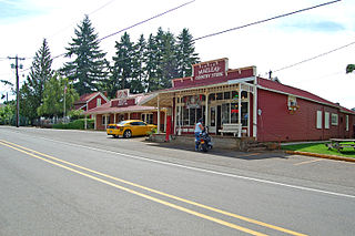
Curtin is an unincorporated community in Douglas County, Oregon, United States. It is on Interstate 5 and the former Southern Pacific railroad line about 7 miles (11 km) northeast of Drain along Pass Creek. It stands at an elevation of 404 feet.
Wonder is an unincorporated community in Josephine County, Oregon, United States, on U.S. Route 199 about 13 miles west of Grants Pass and 8 miles east of Selma. It is within the Rogue River – Siskiyou National Forest.
Macleay is an unincorporated community in Marion County, Oregon, United States, about nine miles east of downtown Salem in the Waldo Hills near the Little Pudding River.
Saint Joseph is an unincorporated community in Yamhill County, Oregon, United States. It is located about two miles west of Lafayette near Oregon Route 99W. The area is sometimes known as "St. Joe".
Nonpareil is an unincorporated historic community in Douglas County, Oregon, United States. It is about 8 miles (13 km) east of Sutherlin, near Calapooya Creek. The population of the area was about 202 in 2000. Nonpareil was the birthplace of novelist H. L. Davis.
Tiernan is an unincorporated community in Lane County, Oregon, United States. It is about five miles west of Mapleton on Oregon Route 126 near the Siuslaw River and within the Siuslaw National Forest.
Walker is an unincorporated community in Lane County, Oregon, United States. It is located about 4 miles (6 km) north of Cottage Grove on Oregon Route 99, near the Coast Fork Willamette River.
Siltcoos is an unincorporated community in Lane County, Oregon, United States. It is about 13 miles (21 km) south of Florence on the east shore of Siltcoos Lake.
Pleasant Valley is an unincorporated community in Josephine County, Oregon, United States. It is located about eleven miles north of Grants Pass, just west of Interstate 5. The community, which is located along the route of the Applegate Trail, is the site of a pioneer cemetery, and at one time it had a school.
Kamela is an unincorporated community in Union County, Oregon, United States. It is located west of Interstate 84 about 20 miles northwest of La Grande.
Crowley is an unincorporated community in Polk County, Oregon, United States. It is located east of Oregon Route 99W, about four miles north of Rickreall.
Clifton is an unincorporated community in Clatsop County, Oregon, United States. It is located north of U.S. Route 30, about nine miles northwest of Westport on the south bank of the Columbia River. It is on Clifton Channel across from Tenasillahe Island.
Suver is an unincorporated community in Polk County, Oregon, United States. It is located about 10 miles north of Corvallis and about 8 miles south of Monmouth, 1 mile east of Oregon Route 99W.
