National Register of Historic Places listings in Hood River County, Oregon
Last updated
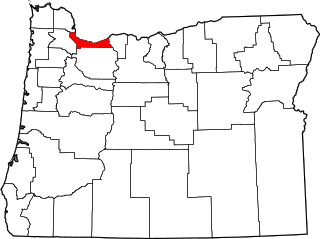
Location of Hood River County in Oregon
This list presents the full set of buildings, structures, objects, sites, or districts designated on the National Register of Historic Places in Hood River County, Oregon, and offers brief descriptive information about each of them. The National Register recognizes places of national, state, or local historic significance across the United States.[1] Out of over 90,000 National Register sites nationwide,[2]Oregon is home to over 2,000,[3] and 38 of those are found partially or wholly in Hood River County.
This 1924 bank was designed by celebrated architect A.E. Doyle, his only Egyptian Revival building in Oregon. The bank was incorporated in 1905 and led by Leslie Butler, one of Hood River's most important businessmen and a prominent philanthropist statewide. The bank folded in 1932.[9]
The opening of the Cascade Locks and Canal in 1896 improved river commerce by allowing Columbia Riversteamboats to bypass the treacherous and usually impossible run through the Cascades Rapids. The canal was rendered unnecessary and partly submerged by construction of the Bonneville Dam in 1938.[10]
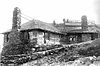
This 1906, late vernacularQueen Anne house is one of the best preserved examples of its style in Hood River. Its size, state of preservation, and fine detail work on its gables especially stand out from similar houses in the area.[13]
Built on Hood River Valleyorchard land in 1910, this may be the finest and most ornate example of Dutch Colonial Revival architecture locally, incorporating many of the distinctive features of the style. The house also displays a high degree of historic integrity on both the exterior and interior, with only minor alterations.[14]
↑ The Barlow Road is a linear district that runs north of and roughly parallel to the line of the White and Salmon rivers from southwest of Wamic to Rhododendron. See also Wasco and Clackamas counties.
↑ The Columbia River Highway Historic District is a linear district with the Sandy River Bridge, Troutdale, at its west end, and the Chenoweth Creek Bridge, The Dalles, at the east end. See also Multnomah and Wasco counties.
↑ The Mount Hood School House is located at the community of Mount Hood, rather than at the mountain for which the community was named.
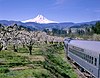
The Mount Hood National Forest is a U.S. National Forest in the U.S. state of Oregon, located 62 miles (100 km) east of the city of Portland and the northern Willamette River valley. The Forest extends south from the Columbia River Gorge across more than 60 miles (97 km) of forested mountains, lakes and streams to the Olallie Scenic Area, a high lake basin under the slopes of Mount Jefferson. The Forest includes and is named after Mount Hood, a stratovolcano and the highest mountain in the state.
The Barlow Road is a historic road in what is now the U.S. state of Oregon. It was built in 1846 by Sam Barlow and Philip Foster, with authorization of the Provisional Legislature of Oregon, and served as the last overland segment of the Oregon Trail. Its construction allowed covered wagons to cross the Cascade Range and reach the Willamette Valley, which had previously been nearly impossible. Even so, it was by far the most harrowing 100 miles (160 km) of the nearly 2,000-mile (3,200 km) Oregon Trail.
This is a list of properties and historic districts in Oregon that are listed on the National Register of Historic Places. There are listings in all of Oregon's 36 counties.
The following list presents the full set of National Register of Historic Places listings in Multnomah County, Oregon. However, please see separate articles for listings in each of Portland's six quadrants.
The following outline is provided as an overview of and topical guide to the U.S. state of Oregon:
Trevitt's Addition Historic District is a neighborhood, primarily residential in character, located in The Dalles, Oregon, United States. Victor Trevitt platted the first expansion of the original 1855 "Dalles City" townsite in 1860, and continued to extend his addition in response to economic developments. The district saw the first flour mill and electrical and water systems in The Dalles, one of the area's earliest Catholic churches, and direct connection to transportation networks including the Columbia River Highway and the railroad. Surviving buildings in the district reflect a continuous spectrum of architectural styles from 1864 to 1937.
↑ Oregon Parks and Recreation Department, Oregon Historic Sites Database, retrieved August 6, 2015. Note that a simple count of National Register records in this database returns a slightly higher total than actual listings, due to duplicate records. A close reading of detailed query results is necessary to arrive at the precise count.
1 2 Numbers represent an alphabetical ordering by significant words. Various colorings, defined here, differentiate National Historic Landmarks and historic districts from other NRHP buildings, structures, sites or objects.
↑ The eight-digit number below each date is the number assigned to each location in the National Register Information System database, which can be viewed by clicking the number.
This page is based on this Wikipedia article Text is available under the CC BY-SA 4.0 license; additional terms may apply. Images, videos and audio are available under their respective licenses.