National Register of Historic Places listings in Lake County, Oregon

Last updated

Location of Lake County in Oregon Map of Oregon highlighting Lake County.svg
Location of Lake County in Oregon

This list presents the full set of buildings, structures, objects, sites, or districts designated on the National Register of Historic Places in Lake County, Oregon, and offers brief descriptive information about each of them. The National Register recognizes places of national, state, or local historic significance across the United States. [1] Out of over 90,000 National Register sites nationwide, [2] Oregon is home to over 2,000, [3] and 19 of those are found in Lake County.

Contents


    This National Park Service list is complete through NPS recent listings posted September 30, 2022. [4]

Current listings

[5] Name on the RegisterImageDate listed [6] Location City or townDescription
1 Abert Lake Petroglyphs
Abert Lake Petroglyphs Abert Lake petroglyph figure.jpg
Abert Lake Petroglyphs
November 20, 1974
(#74002292)
Address restricted [7]
Lakeview vicinity
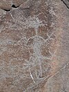
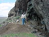
Peoples of the Great Basin cultural tradition pecked these petroglyphs onto two basaltic boulders near major game migration routes, in connection with rituals related to hunting activities. They were made within the last 10,000 years, but cannot be dated more precisely. [8]
2 Bailey and Massingill General Store
Bailey and Massingill General Store Bailey Massingill Store 2014 - Lakeview Oregon.jpg
Bailey and Massingill General Store
October 25, 1984
(#84000133)
4 N. E St.
42°11′23″N120°20′41″W / 42.189645°N 120.344621°W / 42.189645; -120.344621 (Bailey and Massingill General Store)
Lakeview 
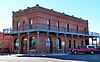
Lakeview's first commercial establishment opened on this site in 1876, and was destroyed by fire in 1900. The owners immediately rebuilt their business, incorporating a unique set of fire preventive features into the new building, including metal-sheathed walls and a fire awning. [9]
3 Cabin Lake Guard Station
Cabin Lake Guard Station Administrative Structure-Oregon 1935.jpg
Cabin Lake Guard Station
April 11, 1986
(#86000827)
Deschutes National Forest
43°29′27″N121°03′22″W / 43.490833°N 121.056111°W / 43.490833; -121.056111 (Cabin Lake Guard Station)
Fort Rock vicinity
4 East Lake Abert Archeological District
East Lake Abert Archeological District East Lake Abert Archeological District - Lake County Oregon.jpg
East Lake Abert Archeological District
November 29, 1978
(#78002295)
Address restricted [7]
Valley Falls vicinity
5 Ed Eskelin Ranch Complex
Ed Eskelin Ranch Complex Eskelin Ranch Complex 2 - Silver Lake Oregon.jpg
Ed Eskelin Ranch Complex
February 25, 1991
(#91000062)
County Road 5-10
43°15′02″N120°54′42″W / 43.250422°N 120.911721°W / 43.250422; -120.911721 (Ed Eskelin Ranch Complex)
Silver Lake vicinityBuilt in the 1930s with both new construction and salvaged materials and buildings, this ranch compound reflects the perseverance of small-scale stock farmers through two phases of settlement in the Fort Rock basin: failed attempts at dryland farming around 1910, then more successful irrigated ventures in the 1930s. [10]
6 Fort Rock Cave
Fort Rock Cave Fort Rock Sandals OHS.jpg
Fort Rock Cave
October 15, 1966
(#66000641)
Address restricted [7]
Fort Rock vicinityThis cave yielded to archeologists the "Fort Rock sandals", the oldest manufactured articles found in the Americas, which demonstrated the early development of weaving among Native Americans. Occupation of the site has been dated to 11,000 BCE. [11]
7 Greaser Petroglyph Site
Greaser Petroglyph Site Greaser Petroglyph Site - Adel Oregon.jpg
Greaser Petroglyph Site
November 20, 1974
(#74002293)
Address restricted [7]
Adel vicinity
8 Heryford Brothers Building
Heryford Brothers Building Heryford Brothers Building - Lakeview Oregon.jpg
Heryford Brothers Building
April 30, 1980
(#80003330)
524 Center St.
42°11′23″N120°20′44″W / 42.189693°N 120.345629°W / 42.189693; -120.345629 (Heryford Brothers Building)
Lakeview
9 William P. Heryford House
William P. Heryford House Heryford House 1 - Lakeview Oregon.jpg
William P. Heryford House
May 22, 1980
(#80003331)
108 S. F St.
42°11′18″N120°20′47″W / 42.188466°N 120.346294°W / 42.188466; -120.346294 (William P. Heryford House)
Lakeview
10 Lake County Round Sale Barn
Lake County Round Sale Barn Lake County Round Sale Barn - Lakeview Oregon.jpg
Lake County Round Sale Barn
November 21, 2003
(#03001180)
3531 N. 6th St.
42°11′43″N120°21′40″W / 42.195342°N 120.361078°W / 42.195342; -120.361078 (Lake County Round Sale Barn)
Lakeview
11 Mitchell Recreation Area
Mitchell Recreation Area Mitchell Monument; August 12, 2013.jpg
Mitchell Recreation Area
February 20, 2003
(#03000050)
Forest Service Rd. 34, Fremont National Forest
42°25′52″N120°51′27″W / 42.431111°N 120.8575°W / 42.431111; -120.8575 (Mitchell Recreation Area)
Bly vicinityIt is the only location in the continental U.S. where Americans were killed during World War II as a direct result of enemy action.
12 Nevada–California–Oregon Railway Passenger Station
Nevada-California-Oregon Railway Passenger Station Old Lakeview Train Station (Lake County, Oregon scenic images) (lakDA0025).jpg
Nevada–California–Oregon Railway Passenger Station
August 22, 1983
(#83002157)
1400 Center St.
42°11′22″N120°21′21″W / 42.189430°N 120.355932°W / 42.189430; -120.355932 (Nevada–California–Oregon Railway Passenger Station)
Lakeview
13 Paisley Five Mile Point Caves
Paisley Five Mile Point Caves Paisley caves - Fossil Cave5.jpg
Paisley Five Mile Point Caves
September 24, 2014
(#14000708)
Address restricted [7]
Paisley vicinity
14 Picture Rock Pass Petroglyphs Site
Picture Rock Pass Petroglyphs Site Picture Rock Pass Petroglyphs 01.JPG
Picture Rock Pass Petroglyphs Site
August 28, 1975
(#75001585)
Address restricted [7]
Silver Lake vicinity
15 Post and King Saloon
Post and King Saloon Post and King Saloon 2 - Lakeview Oregon.jpg
Post and King Saloon
March 17, 1977
(#77001104)
N. 2nd and E Sts.
42°11′27″N120°20′43″W / 42.190738°N 120.345165°W / 42.190738; -120.345165 (Post and King Saloon)
Lakeview
16 David L. Shirk Ranch
David L. Shirk Ranch Shirk Ranch, Lake County, Oregon (Main House).jpg
David L. Shirk Ranch
November 4, 2009
(#09000891)
Guano Valley
42°14′19″N119°31′12″W / 42.2385°N 119.51994°W / 42.2385; -119.51994 (David L. Shirk Ranch)
Adel vicinity
17 Governor Earl W. Snell Aircraft Crash Site
Governor Earl W. Snell Aircraft Crash Site 1947 Snell crash wreckage 07 - Fremont NF Oregon.jpg
Governor Earl W. Snell Aircraft Crash Site
October 18, 2018
(#100003032)
T40S R16E sec25, Fremont–Winema National Forest
42°04′15″N120°46′44″W / 42.070722°N 120.778833°W / 42.070722; -120.778833 (Governor Earl W. Snell Aircraft Crash Site)
Lakeview vicinity
18 Stone Bridge and the Oregon Central Military Wagon Road
Stone Bridge and the Oregon Central Military Wagon Road Stone Bridge, Lake County, Oregon, 1967.png
Stone Bridge and the Oregon Central Military Wagon Road
November 8, 1974
(#74001689)
The Narrows S of Plush
42°21′05″N119°50′26″W / 42.351389°N 119.840556°W / 42.351389; -119.840556 (Stone Bridge and the Oregon Central Military Wagon Road)
Plush vicinity
19 John N. and Cornelia Watson House
John N. and Cornelia Watson House Watson House - Lakeview Oregon.jpg
John N. and Cornelia Watson House
February 21, 1989
(#89000051)
5 N. H St.
42°11′23″N120°20′55″W / 42.189673°N 120.348571°W / 42.189673; -120.348571 (John N. and Cornelia Watson House)
Lakeview

See also

References

  1. Andrus, Patrick W.; Shrimpton, Rebecca H.; et al. (2002), How to Apply the National Register Criteria for Evaluation, National Register Bulletin, National Park Service, U.S. Department of the Interior, OCLC   39493977, archived from the original on April 6, 2014, retrieved June 20, 2014.
  2. National Park Service, National Register of Historic Places Program: Research, archived from the original on February 1, 2015, retrieved January 28, 2015.
  3. Oregon Parks and Recreation Department, Oregon Historic Sites Database , retrieved August 6, 2015. Note that a simple count of National Register records in this database returns a slightly higher total than actual listings, due to duplicate records. A close reading of detailed query results is necessary to arrive at the precise count.
  4. National Park Service, United States Department of the Interior, "National Register of Historic Places: Weekly List Actions", retrieved September 30, 2022.
  5. Numbers represent an alphabetical ordering by significant words. Various colorings, defined here, differentiate National Historic Landmarks and historic districts from other NRHP buildings, structures, sites or objects.
  6. The eight-digit number below each date is the number assigned to each location in the National Register Information System database, which can be viewed by clicking the number.
  7. 1 2 3 4 5 6 Federal and state laws and practices restrict general public access to information regarding the specific location of this resource. In some cases, this is to protect archeological sites from vandalism, while in other cases it is restricted at the request of the owner. See: Knoerl, John; Miller, Diane; Shrimpton, Rebecca H. (1990), Guidelines for Restricting Information about Historic and Prehistoric Resources, National Register Bulletin, National Park Service, U.S. Department of the Interior, OCLC   20706997 .
  8. LeNoue, Marvin (February 11, 1974), National Register of Historic Places Inventory — Nomination Form for Federal Properties: Abert Lake Petroglyph Site.
  9. Bunten, Hugh Jr. (March 30, 1984), National Register of Historic Places Inventory — Nomination Form: Bailey & Massingill General Store (PDF), retrieved November 21, 2014.
  10. Chappel, Jill A. (August 1, 1990), National Register of Historic Places Registration Form: Eskelin, Ed, Ranch Complex (PDF), retrieved January 6, 2015.
  11. National Park Service. "Fort Rock Cave". National Historic Landmark Program: NHL Database. Archived from the original on March 1, 2007. Retrieved March 10, 2012.
Map all coordinates using: OpenStreetMap  
Download coordinates as: KML