East Lake Abert Archeological District

Last updated

East Lake Abert Archeological District
East Lake Abert Archeological District - Lake County Oregon.jpg
Prehistoric stone house ring
Location Lake County, Oregon, U.S. Address restricted [1]
BuiltOver the past 11,000 years
Architectural stylePrehistoric house pits and rock art
NRHP reference No. 78002295
Added to NRHP29 November 1978

The East Lake Abert Archeological District is an area in Lake County, Oregon, United States, that features numerous prehistoric camp sites and petroglyphs. It is located along the eastern shore of Lake Abert on land administered by the Bureau of Land Management and the Oregon Department of Transportation. The site includes stone-walled house pits and prehistoric rock art made by ancient Native Americans who occupied the site for approximately 11,000 years. Because of its unique archaeological and cultural significance, the East Lake Abert Archaeological District was listed on the National Register of Historic Places in 1978.

Contents

Prehistoric environment

Following the last ice age, melt water accumulated in the closed basins of what is now south-central Oregon. As a result, pluvial lakes covered much of Oregon's high desert country. This included the area around what is now Lake Abert. During this period, the area was home to mammoths, bison, horses, camels, and mountain sheep. The abundant wildlife drew prehistoric hunters to the area as well. [2] [3] [4]

About 7,500 years ago, the climate changed and the great pluvial lakes began to recede. As the lakes shrank, the mammoths, horses, and camels disappeared. Nevertheless, the area around Lake Abert and the marshes and meadows along the Chewaucan River, south and west of the lake, remained ideal habitat for wildlife including numerous small mammal species and many varieties of waterfowl. As a result, ancient people continued to occupy the area around Lake Abert. [2] [4] [5]

Little is known about the people who occupied the land, except that they lived and hunted near ancient Lake Abert. [2] [6] Early inhabitants camped, built villages, and carved petroglyphs on boulders along the east shore of Lake Abert for approximately 11,000 years. Over that long period of time, the area had one of the highest human occupation densities found anywhere in the northern region of the Great Basin. [5] [7] [8]

Archeological surveys

There have been two major archeological surveys conducted along the eastern shore of Lake Abert. The first survey was conducted between 1932 and 1935 by Luther Cressman. In 1975 and 1976, David L. Cole and Richard M. Pettigrew of the University of Oregon conducted a second survey prior to a highway project to realign a section of U.S. Route 395, which runs along the eastern shore of Lake Abert. The two archeological surveys identified a significant number of important cultural assets including house pits, domestic artifacts, petroglyphs, and pictographs. In 1985, a team from the University of Oregon published a comprehensive summary of known archeological sites around Lake Abert. [5] [7] [9] [10]

The Lake Abert sites represent at least 11,000 years of human occupation. [5] Archeologists have divided the occupation timeline into six periods. The oldest is the Initial Archaic period from 11,000 to 7,000 years ago. This period is identified by the Great Basin stemmed projectile points found at the Initial Archaic sites. The second period is the Early Archaic which stretched from 7,000 to 4,000 years ago. This period is identified by the northern side-notched points found at Early Archaic locations. The Middle Archaic period covers 4,000 to 2,000 years ago and is divided into two sub-periods. The earlier sub-period is identified by the Gatecliff split-stem points found at its sites, and the more recent sub-period is identified by its Elko series points. The Late Archaic period, which lasted from 2,000 years ago until the mid-18th century, also has two sub-periods. The earlier sub-period is identified by a mix of Elko and Rosegate series points found at its locations, and the last period has only Rosegate points. [5]

Because the prehistoric house pits and petroglyphs along the eastern shore of Lake Abert have great archeological value and are located on federal lands, they have been identified for protection. Like most government-owned prehistoric cultural and rock art sites, the Lake Abert location is officially designated as an "Area of Critical Environmental Concern". This ensures that these valuable cultural resources are preserved and protected. [11] [12]

Because of its cultural significance and unique archaeological value, the East Lake Abert Archeological District was listed on the National Register of Historic Places on 29 November 1978. [7] [11] The Bureau of Land Management has mapped and documented the Lake Abert archeological sites to record its condition. Photographs are used to compare site conditions over time. Volunteers from the Archaeological Society of Central Oregon help Bureau of Land Management cultural and law enforcement specialists monitor the site. [13]

House pits

The original archeological surveys located 32 prehistoric sites along a 12-mile (19 km) section of the eastern shore of Lake Abert. These sites include 21 village areas with at least 371 house pits; 51 of these are round stonewall house pits. Five additional sites have cultural debris, but no house pits. The remaining six sites are clusters of petroglyphs. By 1990, an additional 280 sites were identified. [5] [10]

Today, over 580 house pits and 70 rock rings have been identified at the Lake Abert sites. Many of these sites also have fire hearths, grinding stones, and flaked stone debris. There are very few house pits from the Initial or Early Archaic periods. Most of the villages were built during the Middle Archaic period, so their use period is within the past 4,000 years. [5] [9] [10]

Petroglyphs

The East Lake Abert Archeological District has six rock art groupings plus a number of stand-alone petroglyphs and pictographs located throughout the district. All of the rock art is found on loose boulders that have rolled down from Abert Rim. During the two archeological site surveys, numerous petroglyphs were recorded along with 92 pictographs. There are also some combined or overlapping designs that include both petroglyph and pictograph features. [5] [7] [9]

The rock art designs include both creatures and geometric designs. Among the animal figures are snakes, lizards, and horned toads. Some of the snakes are obviously rattlesnakes, with rattles clearly visible as part of the design. The geometric designs include circles, loops, wavy lines, and some more complex patterns. [9]

Location

The East Lake Abert Archeological District is in Lake County, Oregon. The district covers approximately 300 acres (120 ha) of Bureau of Land Management and Oregon Department of Transportation land along a 12-mile (19 km) section of U.S. Route 395. This section of highway is located between the small unincorporated community of Valley Falls and the north end of Lake Abert. While some of the house pits and petroglyphs are close to the highway, there are no signs or markers to identify the historic district. This helps to protect the fragile archeological sites within the district. [7] [12]

Related Research Articles

Lake County, Oregon County in Oregon, United States

Lake County is one of the 36 counties in the U.S. state of Oregon. As of the 2010 census, the population was 7,895. Its county seat is Lakeview. The county is named after the many lakes found within its boundaries, including Lake Abert, Summer Lake, Hart Lake, and Goose Lake.

Lakeview, Oregon Town in Oregon, United States

Lakeview is a town in Lake County, Oregon, United States. The population was 2,418 at the 2020 census. It is the county seat of Lake County. The city bills itself as the "Tallest Town in Oregon" because of its elevation, 4,802 feet (1,464 m) above sea level. Lakeview is situated in the Goose Lake Valley at the foot of the Warner Mountains and at the edge of Oregon's high desert country. Its economy is based on agriculture, lumber production, and government activities. In addition, tourism is an increasingly important part of the city's economy. Oregon's Outback Scenic Byway passes through Lakeview.

Lake Abert A highly-saline lake in Oregon, United States

Lake Abert is a large, shallow, alkali lake in Lake County, Oregon, United States. It is approximately 15 mi (24 km) long and 7 mi (11 km) wide at its widest point. It is located 3 mi (4.8 km) northeast of the small, unincorporated community of Valley Falls, Oregon. The lake was named in honor of Colonel John James Abert by explorer John C. Fremont during his 1843 expedition into Central Oregon. No fish live in the alkaline waters of the lake; however, its dense population of brine shrimp supports a variety of shorebirds. The lake is also an important stop on the bird migration route known as the Pacific flyway.

Plush, Oregon Census-designated place in Oregon, United States

Plush is an unincorporated rural community and census-designated place in the Warner Valley of Lake County, in the U.S. state of Oregon. As of the 2010 census it had a population of 57. The community is in an arid, sparsely populated part of the state 39 miles (63 km) by road northeast of Lakeview. The valley surrounding Plush contains many marshes and shallow lakes, most of them intermittent.

Coso Rock Art District United States historic place

Coso Rock Art District is a rock art site containing over 100,000 Petroglyphs by Paleo-Indians and/or Native Americans. The district is located near the towns of China Lake and Ridgecrest, California. Big and Little Petroglyph Canyons were declared a National Historic Landmark in 1964. In 2001, they were incorporated into this larger National Historic Landmark District. There are several other distinct canyons in the Coso Rock Art District besides the Big and Little Petroglyph Canyons. Also known as Little Petroglyph Canyon and Sand Tanks, Renegade Canyon is but one of several major canyons in the Coso Range, each hosting thousands of petroglyphs. The majority of the Coso Range images fall into one of six categories: bighorn sheep, entopic images, anthropomorphic or human-like figures, other animals, weapons & tools, and "medicine bag" images.

Valley Falls, Oregon Unincorporated area in Oregon, United States

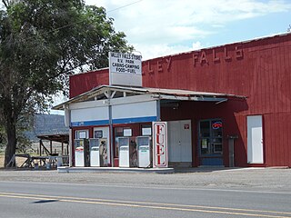
Valley Falls is a small unincorporated community in Lake County, Oregon, United States. The settled area is located at the junction of U.S. Route 395 and Oregon Route 31. The community is named for a small falls on the Chewaucan River just north of the occupied site. East of Valley Falls, the cliff face of Abert Rim overlooks the community.

Greaser Petroglyph Site United States historic place

The Greaser Petroglyph Site is located on land managed by the Bureau of Land Management in eastern Lake County, Oregon. The designs were scraped into a basalt boulder by Native Americans perhaps 12,000 years ago. No one knows the meaning of the designs. Because of its unique archaeological and cultural significance, the Greaser Petroglyph Site was listed on the National Register of Historic Places in 1974.

Warner Valley Valley in south-central Oregon

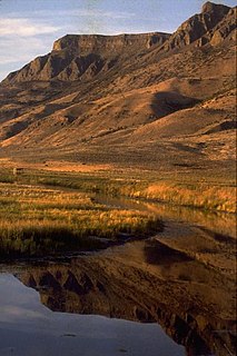
The Warner Valley is a valley in south-central Oregon in the United States. It is a remote valley at the northwestern corner of North America's Basin and Range Province. The valley is home to a chain of lakes and wetlands known as the Warner Lakes. Native Americans were present in the Warner Valley for thousands of years before European explorers arrived in the 19th century. It is the site of Fort Warner, built by the United States Army in 1867. The fort was used as a supply depot and administrative headquarters during a protracted Army campaign against Northern Paiute bands in eastern Oregon and northern California. Today, livestock ranching is the main commercial activity in the valley. The Warner Valley offers a number of recreational opportunities including hunting, fishing, bird watching, and wildlife viewing.

Warner Lakes

The Warner Lakes are a chain of shallow lakes and marshes in the Warner Valley of eastern Lake County, Oregon, United States. The lakes extend the length of the valley, covering approximately 90,000 acres (360 km2).

Hart Lake (Oregon) Lake of the United States of America

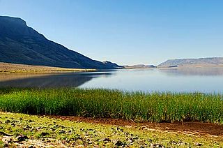
Hart Lake is a shallow lake in the Warner Valley of eastern Lake County, Oregon, United States. The lake covers 7,324 acres (29.64 km2) and has the most stable water level within the valley's Warner Lakes chain. The lake is named for the heart-shaped brand used by the pioneer Wilson and Alexander cattle ranch established near the lake. Much of the land around Hart Lake is administered by the Bureau of Land Management (BLM) and the United States Fish and Wildlife Service (FWS). The lake and the surrounding wetlands support a wide variety of birds and other wildlife. Recreational opportunities on and near Hart Lake include hunting, fishing, bird watching, and boating.

Outline of Colorado prehistory

The following outline is provided as an overview of and topical guide to the prehistoric people of Colorado, which covers the period of when Native Americans lived in Colorado prior to contact with the Domínguez–Escalante expedition in 1776. People's lifestyles included nomadic hunter-gathering, semi-permanent village dwelling, and residing in pueblos.

Picture Rock Pass Petroglyphs Site United States historic place

The Picture Rock Pass Petroglyphs Site is in northern Lake County, Oregon, United States. The site is located near the summit of Picture Rock Pass on land administered by the Bureau of Land Management. The designs were scraped into a basalt boulder by ancient Native Americans, probably between 7,500 and 12,000 years ago. No one knows the meaning of the petroglyph designs. Because of its unique archaeological and cultural significance, the Picture Rock Pass Petroglyph Site was listed on the National Register of Historic Places in 1975.

Catlow Valley

The Catlow Valley is a basin in Harney County, Oregon, United States. It is a remote valley at the northwestern corner of North America's Basin and Range Province. The valley is named after a pioneer rancher, John Catlow. The area was used by Native Americans for thousands of years before European explorers arrived in the 19th century. Today, cattle ranching is the main commercial activity in the valley. The public land in the Catlow Valley is administered by the Bureau of Land Management. This public land offers a number of recreational opportunities including hiking, hunting, fishing, bird watching, and wildlife viewing.

Fossil Lake (Oregon)

Fossil Lake is a dry lakebed in the remote high desert country of northern Lake County in the U.S. state of Oregon. During the Pleistocene epoch, Fossil Lake and the surrounding basin were covered by an ancient lake. Numerous animals used the lake resources. Over time, the remains of many of these animals became fossilized in the lake sediments. As a result, Fossil Lake has been an important site for fossil collection and scientific study for well over a century. Over the years, paleontologists have found the fossil remains of numerous mammals as well as bird and fish species there. Some of these fossils are 2 million years old.

Gerber Reservoir Reservoir in Oregon, USA

Gerber Reservoir is an irrigation impoundment created by Gerber Dam. It is located in southern Klamath County, Oregon, United States. The reservoir covers 3,815 acres (1,544 ha). The dam and reservoir are named in honor of Louis C. Gerber, an early pioneer who owned much of the land flooded by the reservoir. Today, the reservoir and surrounding property is owned by the United States Government. It is administered by the Bureau of Reclamation and the Bureau of Land Management. Gerber Reservoir is a popular outdoor recreation site with two campgrounds along its west shore.

Abert Lake Petroglyphs United States historic place

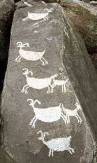
The Abert Lake Petroglyphs are a prehistoric archaeological site in Lake County, Oregon, United States. Peoples of the Great Basin cultural tradition pecked the images onto two basaltic boulders near major game migration routes. They are believed to be connected with rituals related to hunting activities, and contribute to the larger understanding of subsistence patterns in the northern Great Basin. They were made within the last 10,000 years, but their age cannot be stated more precisely due to the difficulty of dating petroglyphs.

Crump Lake (Oregon)

Crump Lake is a shallow lake in the Warner Valley of eastern Lake County, Oregon, United States. The lake covers 7,680 acres (31.1 km2). It is the largest of the Warner Lakes system. The lake is named for pioneer rancher Thomas Crump. Crump Lake is owned by the Oregon Department of State Lands. Much of the land around the lake is administered by the Bureau of Land Management and the United States Fish and Wildlife Service. The lake and the surrounding wetlands support a wide variety of birds and other wildlife. Recreational opportunities on or near Crump Lake include fishing, bird watching, and camping.

The Lower Zuni River Archeological District is an area of approximately 29,500 acres, comprising 89 distinct archeological sites. It is located approximately 24 miles northeast of St. Johns, Arizona, at the Arizona–New Mexico border, along the Zuni River.

Irish Canyon is a valley in Moffat County in northwestern Colorado at 6,099 feet [CONVERT?] in elevation according to United States Geological Survey (USGS). The Bureau of Land Management states that the elevations rise from 6,100 to 8,636 feet. It is a scenic canyon and somewhat remote. It is designated both as the Irish Canyon Natural Area and Irish Canyon Area of Critical Environmental Concern.

References

  1. Federal and state laws and practices restrict general public access to information regarding the specific location of this resource. In some cases, this is to protect archaeological sites from vandalism, while in other cases it is restricted at the request of the owner. See: Knoerl, John; Miller, Diane; Shrimpton, Rebecca H. (1990), Guidelines for Restricting Information about Historic and Prehistoric Resources, National Register Bulletin, National Park Service, U.S. Department of the Interior, OCLC   20706997 .
  2. 1 2 3 Brogan, Phil F., East of the Cascades (Third Edition), Binford and Mort, Portland, Oregon, 1965, pp. 21–23.
  3. Cressman, Luther S., The Sandal and the Cave, Department of Anthropology, University of Oregon, Beaver Books, Portland, Oregon, 1964, pp. 40–41.
  4. 1 2 Richard, Terry, "Paisley Caves added to U.S. list of most important archaeological sites", The Oregonian, Portland, Oregon, 5 October 2014.
  5. 1 2 3 4 5 6 7 8 Aikens, C. Melvin, "Lake Abert" (PDF), Archaeology of Oregon, Lake Abert, Bureau of Land Management, Oregon Office, United States Department of the Interior, Portland, Oregon, 1993, pp. 38–39.
  6. Cressman, Luther S., The Sandal and the Cave, Department of Anthropology, University of Oregon, Beaver Books, Portland, Oregon, 1964, pp. 21–22.
  7. 1 2 3 4 5 David L. Cole (6 June 1977). "National Register of Historic Places Inventory – Nomination Form: East Lake Abert Archaeological District" (PDF). National Park Service . Retrieved 30 November 2015.
  8. Beauchamp, Douglas, "Introduction” (PDF), Material and Remembrance: Three Fractured Petroglyph Boulders, Lake County, Oregon, Eugene, Oregon, January 2013, p. 7.
  9. 1 2 3 4 Cressman, L. S., Petroglyphs of Oregon, University of Oregon, Eugene, Oregon, June 1937, p. 27.
  10. 1 2 3 Gilsen, Leland, "Prehistoric Architecture of Oregon", Prehistoric Architecture of Oregon, Salem, Oregon, 13 April 2014.
  11. 1 2 "Cultural Resources" (PDF), Summary of the Analysis of the Management Situation for the Lakeview Resource Area – Resource Management Plan, Lakeview Field Office, Lakeview District, Bureau of Land Management, United States Department of the Interior, Lakeview, Oregon, July 2000, pp. 2.28–2.29.
  12. 1 2 Beauchamp, Douglas, "Introduction”, Material and Remembrance: Three Fractured Petroglyph Boulders, Lake County, Oregon, Eugene, Oregon, January 2013, p. 5.
  13. Preserve America Report Archived 24 September 2015 at the Wayback Machine (PDF), Cultural Resource Management Program, Bureau of Land Management, United States Department of the Interior, Washington, D.C., September 2004, p. 18.