Lake County is one of the 36 counties in the U.S. state of Oregon. As of the 2020 census, the population was 8,160. Its county seat is Lakeview. The county is named after the many lakes found within its boundaries, including Lake Abert, Summer Lake, Hart Lake, and Goose Lake.

A petroglyph is an image created by removing part of a rock surface by incising, picking, carving, or abrading, as a form of rock art. Outside North America, scholars often use terms such as "carving", "engraving", or other descriptions of the technique to refer to such images. Petroglyphs, estimated to be 20,000 years old are classified as protected monuments and have been added to the tentative list of UNESCO's World Heritage Sites. Petroglyphs are found worldwide, and are often associated with prehistoric peoples. The word comes from the Greek prefix petro-, from πέτρα petra meaning "stone", and γλύφω glýphō meaning "carve", and was originally coined in French as pétroglyphe.

In the history of art, prehistoric art is all art produced in preliterate, prehistorical cultures beginning somewhere in very late geological history, and generally continuing until that culture either develops writing or other methods of record-keeping, or makes significant contact with another culture that has, and that makes some record of major historical events. At this point ancient art begins, for the older literate cultures. The end-date for what is covered by the term thus varies greatly between different parts of the world.

Winnemucca Lake is a dry lake bed in northwest Nevada that features the oldest known petroglyphs in North America. Located astride the border between Washoe and Pershing counties, it was a shallow lake until the 1930s, but was dried when a dam and a road were built that combined to restrict and block water flow. It was formerly designated as a National Wildlife Refuge, but its status as a refuge was removed due to the lack of water.
Central Norway is a region in Norway, comprising Trøndelag as well as parts of the Nordland and Møre og Romsdal counties.

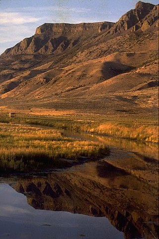
Lake Abert is a large, shallow, alkali lake in Lake County, Oregon, United States. It is approximately 15 mi (24 km) long and 7 mi (11 km) wide at its widest point. It is located 3 mi (4.8 km) northeast of the small, unincorporated community of Valley Falls, Oregon. The lake was named in honor of Colonel John James Abert by explorer John C. Fremont during his 1843 expedition into Central Oregon. No fish live in the alkaline waters of the lake; however, its dense population of brine shrimp supports a variety of shorebirds. The lake is an important stop on the bird migration route known as the Pacific flyway.

Sydney rock engravings, or Sydney rock art, are a form of Australian Aboriginal rock art in the sandstone around Sydney, New South Wales, Australia, that consist of carefully drawn images of people, animals, or symbols. Many thousands of such engravings are known to exist in the Sydney region, although the locations of most are not publicised to prevent damage by vandalism, and to retain their sanctity, as they are still regarded as sacred sites by Indigenous Australians. There are two art environments in Sydney Basin, rock shelters and engraving sites.
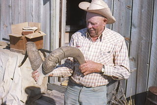
Reuben Aaron Long was an Eastern Oregon rancher, author, and story teller. He was known throughout Oregon as a witty and wise cowboy philosopher. In 1964, he joined E.R. Jackman to write The Oregon Desert, which is still a very popular book fifty years after its original publication.
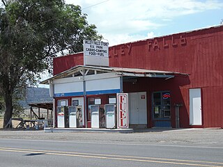
Valley Falls is a small unincorporated community in Lake County, Oregon, United States. The settled area is located at the junction of U.S. Route 395 and Oregon Route 31. The community is named for a small falls on the Chewaucan River just north of the occupied site. East of Valley Falls, the cliff face of Abert Rim overlooks the community.

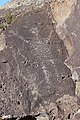
The Greaser Petroglyph Site is located on land managed by the Bureau of Land Management in eastern Lake County, Oregon. The designs were scraped into a basalt boulder by Native Americans perhaps 12,000 years ago. No one knows the meaning of the designs. Because of its unique archaeological and cultural significance, the Greaser Petroglyph Site was listed on the National Register of Historic Places in 1974.
The Warner Valley is a valley in south-central Oregon in the United States. It is a remote valley at the northwestern corner of North America's Basin and Range Province. The valley is home to a chain of lakes and wetlands known as the Warner Lakes. Native Americans were present in the Warner Valley for thousands of years before European explorers arrived in the 19th century. It is the site of Fort Warner, built by the United States Army in 1867. The fort was used as a supply depot and administrative headquarters during a protracted Army campaign against Northern Paiute bands in eastern Oregon and northern California. Today, livestock ranching is the main commercial activity in the valley. The Warner Valley offers a number of recreational opportunities including hunting, fishing, bird watching, and wildlife viewing.

The Warner Lakes are a chain of shallow lakes and marshes in the Warner Valley of eastern Lake County, Oregon, United States. The lakes extend the length of the valley, covering approximately 90,000 acres (360 km2).
Hart Lake is a shallow lake in the Warner Valley of eastern Lake County, Oregon, United States. The lake covers 7,324 acres (29.64 km2) and has the most stable water level within the valley's Warner Lakes chain. The lake is named for the heart-shaped brand used by the pioneer Wilson and Alexander cattle ranch established near the lake. Much of the land around Hart Lake is administered by the Bureau of Land Management (BLM) and the United States Fish and Wildlife Service (FWS). The lake and the surrounding wetlands support a wide variety of birds and other wildlife. Recreational opportunities on and near Hart Lake include hunting, fishing, bird watching, and boating.

Derrick Cave is a lava tube located in the remote northwest corner of Lake County, Oregon. The cave is approximately 1,200 feet (370 m) long. It is up to 80 feet (24 m) wide and 46 feet (14 m) high in places. It was named in honor of H.E. Derrick, a pioneer rancher with a homestead 3 miles (4.8 km) southeast of the cave. The land around the cave is managed by the United States Department of Interior, Bureau of Land Management. Derrick Cave is open to the public year-round; however, camping is no longer permitted in the cave.

The Catlow Valley is a basin in Harney County, Oregon, United States. It is a remote valley at the northwestern corner of North America's Basin and Range Province. The valley is named after a pioneer rancher, John Catlow. The area was used by Native Americans for thousands of years before European explorers arrived in the 19th century. Today, cattle ranching is the main commercial activity in the valley. The public land in the Catlow Valley is administered by the Bureau of Land Management. This public land offers a number of recreational opportunities including hiking, hunting, fishing, bird watching, and wildlife viewing.

Fossil Lake is a dry lakebed in the remote high desert country of northern Lake County in the U.S. state of Oregon. During the Pleistocene epoch, Fossil Lake and the surrounding basin were covered by an ancient lake. Numerous animals used the lake's resources. Over time, the remains of many of these animals became fossilized in the lake sediments. As a result, Fossil Lake has been an important site for fossil collection and scientific study for well over a century. Over the years, paleontologists have found the fossil remains of numerous mammals as well as bird and fish species there. Some of these fossils are 2 million years old.

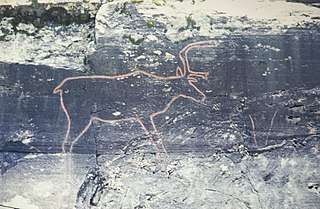
The East Lake Abert Archeological District is an area in Lake County, Oregon, United States, that features numerous prehistoric camp sites and petroglyphs. It is located along the eastern shore of Lake Abert on land administered by the Bureau of Land Management and the Oregon Department of Transportation. The site includes stone-walled house pits and prehistoric rock art made by ancient Native Americans who occupied the site for approximately 11,000 years. Because of its unique archaeological and cultural significance, the East Lake Abert Archaeological District was listed on the National Register of Historic Places in 1978.

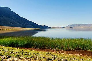
Crump Lake is a shallow lake in the Warner Valley of eastern Lake County, Oregon, United States. The lake covers 7,680 acres (31.1 km2). It is the largest of the Warner Lakes system. The lake is named for pioneer rancher Thomas Crump. Crump Lake is owned by the Oregon Department of State Lands. Much of the land around the lake is administered by the Bureau of Land Management and the United States Fish and Wildlife Service. The lake and the surrounding wetlands support a wide variety of birds and other wildlife. Recreational opportunities on or near Crump Lake include fishing, bird watching, and camping.

The Ambadevi rock shelters are part of an extensive cave site, where the oldest yet known traces of human life in the central province of the Indian subcontinent were discovered. The site is located in the Satpura Range of the Gawilgarh Hills in Betul District of the Indian state of Madhya Pradesh, north of Dharul village in Amravati district of Maharashtra. Studies of various rock paintings and petroglyphs present in the caves suggest, that the Ambadevi rock shelters were inhabited by prehistoric human settlers since around 25,000 years ago. First discoveries of clusters of numerous rock shelters and caves were made by Vijay Ingole and his team beginning on 27 January 2007. Named after the nearby ancient Ambadevi Cave Temple, the site has also been referred to as the Satpura-Tapti valley caves and the Gavilgarh-Betul rock shelters. The Ambadevi rock shelters rank among the most important archaeological discoveries of the early 21st Century in India, on par with the 20th Century discovery of the Bhimbetka rock shelters.
Petroglyphs of Lake Onega and the White Sea is a UNESCO World Heritage Site in Russia, Republic of Karelia, listed on 28 July 2021. The World Heritage Site comprises 33 petroglyph sites in two clusters. The rock carvings were created from 7 to 4 millennia ago and represent a glimpse into the lives of Neolithic cultures of Fennoscandia.