David L. Shirk Ranch

Last updated

David L. Shirk Ranch
Shirk Ranch, Lake County, Oregon (Main House).jpg
Abandoned house at the Shirk Ranch
USA Oregon location map.svg
Red pog.svg
Usa edcp location map.svg
Red pog.svg
Location Lake County, Oregon, USA
Nearest city Lakeview, Oregon, USA
Coordinates 42°14′19″N119°31′12″W / 42.23850°N 119.51994°W / 42.23850; -119.51994
Built1881 to 1910
Architectural styleSimple vernacular
NRHP reference No. 09000891
Added to NRHP2009

The David L. Shirk Ranch is a historic ranch located in the Guano Valley of eastern Lake County, Oregon, United States. The ranch was originally homesteaded in 1881. It was purchased by David L. Shirk in 1883. He operated the ranch until 1914. The property was acquired by the United States Government in 1942. The ranch is now administered by the Bureau of Land Management. The remaining historic ranch buildings are listed on the National Register of Historic Places.

Contents

Early history

The Shirk Ranch is located on Bureau of Land Management property in the remote Guano Valley of southeastern Oregon. The ranch complex is in the Oregon high desert, just south of the Hart Mountain National Antelope Refuge in the northwest corner of the Great Basin region of North America. Native peoples inhabited the area for at least 10,000 years prior to the arrival of European explorers. The Northern Paiutes occupied the area prior to the arrival of European settlers. They had adapted to the high desert environment by living in scattered groups and moving frequently to take advantage of season lakes and migrating game animals. [1] [2]

In the first half of the 19th century, the area around the Shirk Ranch was explored by trappers and several military expeditions. [1] In 1865, the United States Army built Old Camp Warner on the southeastern slope of Hart Mountain along upper Guano Creek. However, the post was abandoned within a year. [3] A few years later, the Oregon Central Military Wagon Road was built through the Guano Valley on its way from Eugene, Oregon to Silver City, Idaho. However, that venture was really a scam intended to acquire government land rather than create a viable road. As a result, the "road" was never more than a desert track. [4] There was no permanent settlement in the area until a decade later when cattlemen began to take advantage of the open range in southeastern Oregon for grazing. [1]

The Shirk Ranch property was originally homesteaded by R.A. Turner around 1881 and then sold to William Herron. Shirk bought the ranch from Herron in 1883. When Shirk purchased the land, there were three building on the property, a house and two sheds. There is no record of the size of the property when Shirk bought it, but county tax records show the ranch was 480 acres in 1887. [5]

David Shirk

David L. Shirk was born in Parke County, Indiana in 1844. He was the oldest of nine children. He left home at the age of 22 to travel west. He spent several years working as a cowboy on cattle drives from Texas to southern Idaho. His younger brother William joined him in 1874, and together they moved to Oregon. They both made land claims in the Catlow Valley in what is now Harney County, Oregon. [1] [5]

David Shirk at age 28 David Lawson Shirk, 1872.jpg
David Shirk at age 28

Later, the brothers acquired land in neighboring Guano Valley, approximately 50 miles west of their Catlow Valley ranch. They used the Guano Valley ranch to raise horses, while their main Catlow Valley ranch was a cattle operation. [1] [5] They were successful enough at their cattle business that their ranch became the social center for the local ranching community. [6] Eventually, a post office was opened at their Catlow Valley ranch. The Shirk post office was moved to their Guano Lake ranch in 1903, where it continued through 1905. [7]

The Catlow Valley was the scene of a number of Indian attacks during the Bannock War of 1878. Both Shirk brothers were engaged in defending their ranch. In one incident, William Shirk and two teamsters were ambushed. His two companions were killed outright and the Indians pursued Shirk for several miles before giving up the chase. [8]

The Shirk brothers eventually acquired about 50,000 acres (200 km2), controlling much of the water in the Catlow Valley. This was quite contentious since the vast P Ranch owned by cattle baron Peter French extended south into the Catlow Valley as well. As result, the Shirks had to compete with French for Catlow Valley grazing land and water. During one skirmish over a land claim in 1889, David Shirk shot and killed one of French's employees. Shirk was tried for murder and acquitted. [5]

After the trial, Shirk moved his home ranch west from the Catlow Valley to his Guano Valley property, probably to help avoid conflict with French and his employees. By 1899, Shirk had increased his Guano Valley parcel to 1,080 acres (4.4 km2). In 1914, Shirk sold his ranch holdings to pursue other business opportunities. Eventually, he moved to Berkeley, California, where he died in 1928. [5] [7]

Bureau of Land Management

Shirk sold his ranch to the Lake County Land and Livestock Company which owned the neighboring 7T Ranch. This allowed the 7T Ranch to extend its grazing eastward from its home range in the Warner Valley. In 1928, the ranch was bought by a Cedarville, California partnership, Mitchell and McDaniel. However, the property was taken by the Bank of Willows (California) in a foreclosure action that same year. For a number of years, the bank leased the property to Zetus Spaulding, who was married to David Shirk's daughter, Olive. The United States Government acquired the property in 1942, but Spaulding continued to live at the ranch until his death in 1945. Today, the property is administered by the Bureau of Land Management. [5]

The Shirk Ranch site in the Guano Valley borders an emergent marsh and meadow lands watered by Guano Creek, which drains the southeastern slope of Hart Mountain. The area provides habitat for migrating waterfowl as well as local birds and wildlife. Bureau of Land Management actively manages the cattle grazing leases in the area to preserve the wetland habitat and ensure wildlife diversity around the historic ranch complex. [9]

Because it is an excellent example of a pioneer cattle ranch in southeastern Oregon, the Shirk Ranch was listed on the National Register of Historic Places on November 4, 2009. The historic district covers 14.5 acres (0.059 km2). There are nineteen structures in the historic district. Fourteen are contributing elements and five are non-contributing. Today, the historic Shirk Ranch suffers from benign neglect. The ranch has never been fully inventoried to determine the significance of its assets and none of the buildings have been stabilized or restored. As a result, several of the historic buildings are in poor condition. [1] [10]

Structures

The Shirk Ranch complex included seven historic buildings and five other contributing structures plus two separate contributing sites, the ranch dump area and a grave. Most of the ranch buildings were constructed during two periods. The first phase was in the early 1880s and then a second surge of building around 1910. The ranch building constructed in the 1880s included the original ranch house (today, only a stone fireplace is left standing), the oldest part of the blacksmith shop, and a small stone-clad shed which has collapsed. Around 1910, Shirk added a number of other buildings. These include the existing main house, two bunkhouses, a barn, a wood shed, a root cellar, an outhouse, a chicken coop/animal shed, a water tower, two wells, original fences, and the hand-dug irrigation system. All of these buildings are wood-frame structures covered either in horizontal weatherboard or vertical wood planking with wood-shingle roofing. All of the buildings were painted at one time. The main house was painted white. All the other buildings were painted red. [1] [5]

David L. Shirk Ranch Historic District Shirk Ranch Historic District, Lake County, Oregon.png
David L. Shirk Ranch Historic District

The historic district has fourteen contributing elements. They include the main house, two bunkhouses, a blacksmith shop, a wood shed, an outhouse, a chicken coop/animal shed, a water tower, two wells, original fences, and the hand-dug irrigation system. All of these historic elements are part of the main ranch complex which covers 13.1 acres (0.053 km2). There are two additional contributing elements, a dump area and a grave site, located on two small non-contiguous parcels of land west of the main ranch complex. Together the three sites comprise a 14.5 acres (0.059 km2) historic district. [1]

The remaining historic structures are in such poor condition the Bureau of Land Management listed them as non-contributing elements when the Shirk Ranch site was nominated for the National Register of Historic Places. They include a caved-in root cellar, a collapsed barn, the remains of a rock-clad shed, and an old ranch house ruin. [1]

There is only one non-historic structure on the site, an animal feed lot located at the southern end of the ranch complex. It was built in 1980 for modern ranch operations at the site. While it does not have any historic significance, the Bureau of Land Management has decided not to remove the structure since it is isolated from all of the contributing historic structures. [1]

Location

The Shirk Ranch Historic District is located on Bureau of Land management property in southeastern Oregon. The historic district covers 14.5 acres (0.059 km2). The ranch is in Oregon's high desert county at an elevation of approximately 5,200 feet (1,600 m) above sea level. [1] [2] [11]

The Shirk Ranch is approximately 68 miles (109 km) east of Lakeview, Oregon. It is reached by traveling east from Lakeview on Oregon Route 140 for 52 miles (84 km), then turning north on Bureau of Land Management Road 6106 and following it for 12 miles (19 km). The historic Shirk Ranch is on the right side of the road. [1] [2] [11]

Related Research Articles

The Rio Grande Ranch Headquarters Historic District is a historic one-story residence located 3 miles (4.8 km) east of Okay in Wagoner County, Oklahoma. The site was listed on the National Register of Historic Places September 9, 1992. The site's Period of Significance is 1910 to 1935, and it qualified for listing under NRHP criteria A and C.

<span class="mw-page-title-main">Buckner Homestead Historic District</span> Historic district in Washington, United States

The Buckner Homestead Historic District, near Stehekin, Washington in Lake Chelan National Recreation Area incorporates a group of structures relating to the theme of early settlement in the Lake Chelan area. Representing a time period of over six decades, from 1889 to the 1950s, the district comprises 15 buildings, landscape structures and ruins, and over 50 acres (200,000 m2) of land planted in orchard and criss-crossed by hand-dug irrigation ditches. The oldest building on the farm is a cabin built in 1889. The Buckner family bought the farm in 1910 and remained there until 1970, when the property was sold to the National Park Service. The Buckner Cabin was listed on the National Register of Historic Places in 1974. The rest of the Buckner farm became a historic district in 1989. Today, the National Park Service maintains the Buckner homestead and farm as an interpretive center to give visitors a glimpse at pioneer farm life in the Stehekin Valley.

<span class="mw-page-title-main">Faraway Ranch Historic District</span> Historic district in Arizona, United States

The Faraway Ranch Historic District is part of the Chiricahua National Monument in southeastern Arizona, and preserves an area associated with the final conflicts with the local Apache, one of the last frontier settlements, and in particular, its association with the people who promoted the establishment of the Chiricahua National Monument. Faraway Ranch is located in Bonita Canyon, which lies at an approximate altitude of 5160 feet and opens in a southwesterly direction into the Sulphur Springs Valley.

<span class="mw-page-title-main">Rogue River Ranch</span> United States historic place

The Rogue River Ranch is a pioneer farm complex in Curry County in southwest Oregon, United States. The ranch is located on the north shore of the Rogue River just outside the Rogue River-Siskiyou National Forest. The original ranch buildings were constructed by George Billings. Later, the ranch was sold to Stanley Anderson, who increased the size of the property and built additional farm buildings. The Bureau of Land Management bought the ranch in 1970. Today, the main ranch house is a museum. The Bureau of Land Management also maintains a campground on the property. The Rogue River Ranch is listed on the National Register of Historic Places.

<span class="mw-page-title-main">Manning–Kamna Farm</span> Historic house in Oregon, United States

The Manning–Kamna Farm is a private farm adjacent to Hillsboro in Washington County, Oregon, United States. Settled in the 1850s, ten buildings built between 1883 and 1930 still stand, including the cross-wing western farmhouse. These ten structures comprise the buildings added to the National Register of Historic Places in 2007 as an example of a farm in the region from the turn of the 20th century. Until the 1950s the farm was used to grow seeds, including rye grass and vetch. Listed buildings on the property include a barn, smokehouse, pumphouse, woodshed, and privy.

<span class="mw-page-title-main">Zigzag Ranger Station</span> United States historic place

The Zigzag Ranger Station is a Forest Service compound consisting of twenty rustic buildings located in Oregon's Mount Hood National Forest. It was built as the administrative headquarters for the Zigzag Ranger District. It is located in the small unincorporated community of Zigzag, Oregon. Many of the historic buildings were constructed by the Civilian Conservation Corps between 1933 and 1942. Today, the Forest Service still uses the ranger station as the Zigzag Ranger District headquarters. The ranger station is listed on the National Register of Historic Places.

<span class="mw-page-title-main">Charles Boyd Homestead Group</span> United States historic place

The Charles Boyd Homestead is a group of three buildings that make up a pioneer ranch complex. It is located in Deschutes County north of Bend, Oregon, United States. The ranch buildings were constructed by Charles Boyd between 1905 and 1909. Today, the three surviving structures are the only ranch buildings that date back to the earliest period of settlement in the Bend area. The Boyd Homestead is listed as a historic district on the National Register of Historic Places.

<span class="mw-page-title-main">Tiller Ranger Station</span> United States historic place

The Tiller Ranger Station is a United States Forest Service compound consisting of twenty-seven buildings in Oregon’s Umpqua National Forest. Over the years, it has been the administrative headquarters for five ranger districts. It is located in the small unincorporated community of Tiller, Oregon, United States. The historic structures were built in the rustic style by the Civilian Conservation Corps between 1935 and 1942. Today, the ranger station is the headquarters for the Tiller Ranger District, and is listed on the National Register of Historic Places.

<span class="mw-page-title-main">Terwilliger–Smith Farm</span> United States historic place

The Terwilliger–Smith Farm is located on Cherrytown Road near the hamlet of Kerhonkson in the Town of Rochester in Ulster County, New York, United States. It was established in the mid-19th century.

<span class="mw-page-title-main">Unity Ranger Station</span> United States historic place

The Unity Ranger Station is a United States Forest Service compound consisting of five buildings and a lookout tower in the Wallowa-Whitman National Forest of northeastern Oregon. It was previously the administrative headquarters for the Unity Ranger District. It is located in the small unincorporated community of Unity, Oregon. The historic structures were built in the rustic style by the Civilian Conservation Corps between 1936 and 1938. Today, the ranger station is only used during the summer months to house Forest Service fire crews. The ranger station is listed on the National Register of Historic Places.

<span class="mw-page-title-main">James Cant Ranch Historic District</span> Historic district in Oregon, United States

The James Cant Ranch is a pioneer ranch complex in Grant County in eastern Oregon, United States. The ranch is located on both sides of the John Day River in the John Day Fossil Beds National Monument. The ranch was originally homesteaded by Floyd Officer in 1890. Officer sold the property to James Cant in 1910. Cant increased the size of the property and built a modern ranch complex on the west bank of the river. The National Park Service bought the ranch from the Cant family in 1975, and incorporated the property into the John Day Fossil Beds National Monument. The National Park Service used the main house as a visitor center until 2003. Today, the Cant Ranch complex is preserved as an interpretive site showing visitors an early 20th-century livestock ranch. The James Cant Ranch is listed on the National Register of Historic Places.

<span class="mw-page-title-main">P Ranch</span> United States historic place

The P Ranch is a historic ranch in Harney County in southeastern Oregon, United States. The remaining ranch structures are located on the west bank of the Donner und Blitzen River in the Malheur National Wildlife Refuge. The ranch was built by Peter French, a well known 19th-century cattle baron. The P Ranch became headquarters for the French-Glenn Livestock Company, which eventually covered over 140,000 acres (570 km2). After French was murdered in 1897, the French-Glenn Livestock Company slowly sold off the P Ranch property. In 1935, the United States Government purchased the remaining P Ranch property to add to an adjacent wildlife refuge. The Civilian Conservation Corps demolished most of the original ranch buildings in the 1930s, and a fire destroyed the main ranch house in 1947. The few remaining P Ranch structures are now listed on the National Register of Historic Places.

<span class="mw-page-title-main">Sod House Ranch</span> United States historic place

The Sod House Ranch is a historic ranch in Harney County in southeastern Oregon, United States. The remaining ranch structures are located south of Malheur Lake in the Malheur National Wildlife Refuge. The ranch was built by Peter French, a well known 19th-century cattle baron. The Sod House Ranch became the headquarters for the northern operating division of the French-Glenn Livestock Company, which eventually covered over 140,000 acres (570 km2). After French was murdered in 1897, the French-Glenn Livestock Company slowly sold off its ranch property. In 1935, the United States Government purchased the Sod House Ranch property to add to an adjacent wildlife refuge. The eight remaining Sod House Ranch buildings are now listed on the National Register of Historic Places.

<span class="mw-page-title-main">Lake of the Woods Ranger Station</span> United States historic place

The Lake of the Woods Ranger Station is a United States Forest Service compound consisting of eight buildings overlooking Lake of the Woods in the Fremont-Winema National Forests of southern Oregon. All of the ranger station structures were built by the Civilian Conservation Corps between 1937 and 1939. Today, the compound serves as a Forest Service work center, and the old ranger station office is a visitor center. The ranger station is listed on the National Register of Historic Places.

<span class="mw-page-title-main">Roba Ranch</span> United States historic place

The Roba Ranch is a pioneer ranch located near the small unincorporated community of Paulina in Crook County, Oregon. The ranch is named for George and Mary Roba, sheep ranchers who acquired the property in 1892. Most of the important ranch buildings were constructed by the Roba family between about 1892 and 1910. Today, the ranch covers 1,480 acres (6.0 km2) and is privately owned. The ranch was listed on the National Register of Historic Places in 2007.

<span class="mw-page-title-main">Catlow Valley</span>

The Catlow Valley is a basin in Harney County, Oregon, United States. It is a remote valley at the northwestern corner of North America's Basin and Range Province. The valley is named after a pioneer rancher, John Catlow. The area was used by Native Americans for thousands of years before European explorers arrived in the 19th century. Today, cattle ranching is the main commercial activity in the valley. The public land in the Catlow Valley is administered by the Bureau of Land Management. This public land offers a number of recreational opportunities including hiking, hunting, fishing, bird watching, and wildlife viewing.

<span class="mw-page-title-main">Elk Lake Guard Station</span> United States historic place

The Elk Lake Guard Station is a United States Forest Service cabin located in the Deschutes National Forest southwest of Bend, Oregon. The guard station was built in 1929 on the north shore of Elk Lake. It was used as a home base for Forest Service personnel who protected forest resources, maintained facilities, and aided summer visitors in the Cascade Lakes area of Central Oregon. After decades of use, the cabin was renovated in the late 1990s. Today, the historic guard station serves as a Forest Service visitor information center along the Cascade Lakes Scenic Byway. The Elk Lake Guard Station is listed on the National Register of Historic Places.

<span class="mw-page-title-main">Stahly–Nissley–Kuhns Farm</span> United States historic place

The Stahly–Nissley–Kuhns Farm is a historic farm located at Nappanee, Elkhart County, Indiana. Nappanee was established in 1874. The Farm is part of Amish Acres, which includes the old farmstead and additional structures brought in to show Amish life.

<span class="mw-page-title-main">Colter Ranch Historic District</span> Historic district in Arizona, United States

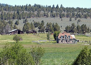
The Colter Ranch Historic District consists of twelve buildings in a rural setting near Eagar, Arizona. The site is located in the Amity Valley, which itself is part of Round Valley ; the Little Colorado River runs along the one side of the district. Most of the buildings date from between 1904 and 1930, the period during which Fred Colter resided on the residence.

<span class="mw-page-title-main">Booth-Dunham Estate</span> United States historic place

The Booth-Dunham Estate is a single-family home located at 6059 South Ninth Street Texas Charter Township near Kalamazoo, Michigan. It was listed on the National Register of Historic Places in 1998.

References

  1. 1 2 3 4 5 6 7 8 9 10 11 12 13 14 15 16 17 18 19 20 21 22 23 24 25 26 "David L. Shirk Ranch", National Register of Historic Places Registration Form, National Park Service, United States Department of Interior, Washington, D.C., 24 September 2009.
  2. 1 2 3 Housley, Lucile A., "Guano Creek/Sink Lakes", Kalmiopsis (Vol. 11), Native Plant Society of Oregon, Eugene, Oregon, p. 10.
  3. McArthur, Lewis A. and Lewis L. McArthur, "Camp Warner", Oregon Geographic Names (Seventh Edition), Oregon Historical Society Press, Portland, Oregon, 2003, pp. 152-153.
  4. "Oregon History: Uncle Sam’s Handiwork", Oregon Blue Book , Oregon State Archives, Office of the Secretary of State, State of Oregon, Salem, Oregon, 17 September 2009.
  5. 1 2 3 4 5 6 7 8 9 10 11 12 13 14 15 16 17 18 19 20 "Shirk Ranch" Archived October 9, 2012, at the Wayback Machine , Cultural Resource Inventory: Sheldon National Wildlife Refuge and Hart Mountain National Wildlife Refuge, United States Fish and Wildlife Service, United States Department of Interior, Portland, Oregon, February 1985, pp 57-70.
  6. Jackman, E. R. and John Scharff, Steens Mountain in Oregon’s High Desert Country, Caxton Printers, Caldwell, Idaho, 1967, p. 176.
  7. 1 2 McArthur, Lewis A. and Lewis L. McArthur, "Shirk", Oregon Geographic Names (Seventh Edition), Oregon Historical Society Press, Portland, Oregon, 2003, p. 871.
  8. Thompson, William, "The Great Bannock War", Reminiscences of a Pioneer - William Thompson , San Francisco, 1912, p. 136.
  9. Ivey, Gary L., "Guano Creek" Archived 2011-10-03 at the Wayback Machine , Oregon Closed Basin, Oregon Wetland Joint Venture Joint, Venture Implementation Plans for Eastern Oregon, Oregon Department of Fish and Wildlife and Ducks Unlimited, Lake Oswego, Oregon, 28 September 2000, pp.14-15.
  10. "Cultural resources at Risk" Archived 2011-06-15 at the Wayback Machine , America’s Priceless Heritage: Cultural and Fossil Resources on Public Land—Oregon/Washington, Bureau of Land Management, United States Department of Interior, November 2003, p. 5.
  11. 1 2 Oregon topographic map, United States Geological Survey, United States Department of Interior, Reston, Virginia; displayed via ACME mapper, www.acme.com, 29 August 2010.