Cove is a city in Union County, Oregon, United States. The population was 552 at the 2010 census.

Summerville is a city in Union County, Oregon, United States. The population was 135 at the 2010 census.

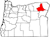
Wallowa is a city in Wallowa County, Oregon, United States. The population was 808 at the 2010 census.

Minam is an unincorporated community in northwestern Wallowa County, Oregon, United States. It is located at the confluence of the Minam and Wallowa rivers, north of the Wallowa Mountains on Oregon Route 82. Minam is approximately 20 miles (32 km) Northeast of La Grande.

Flora is an unincorporated community in Wallowa County, Oregon, United States. It is located about 35 miles north of Enterprise, just off Oregon Route 3, and is considered a ghost town. Its elevation is 4350 ft. The community includes 6 mines.
Alicel is an unincorporated community in the Sand Ridge area of the Grande Ronde Valley in Union County, Oregon, United States. It is northeast of La Grande on Oregon Route 82. It was a station on Union Pacific Railroad's Joseph branch, and in 1890 was named for Alice Ladd, wife of local resident Charles Ladd. Alicel was platted in 1890, and had a post office from 1890 until 1972.
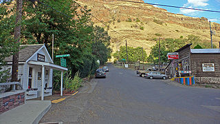
Imnaha is an unincorporated community at the confluence of Big Sheep Creek and the Imnaha River in Wallowa County, Oregon, United States. Its elevation is 1,978 feet (603 m). Oregon Route 350 connects Imnaha to the nearest incorporated city, Joseph, 30 miles (48 km) to the west. Imnaha is best known as the gateway to the Hat Point scenic lookout on Hells Canyon at the Snake River.

Whitney is an unincorporated community, also considered a ghost town, in Baker County, Oregon, United States, on Oregon Route 7 southwest of Sumpter. It is on the North Fork Burnt River, near the Blue Mountains and Wallowa-Whitman National Forest.
Auburn was an unincorporated community in rural Baker County, Oregon, United States, now considered a ghost town. Auburn lies off Oregon Route 7 southwest of Baker City and east of McEwen on the edge of the Blue Mountains.

McEwen is an unincorporated community in Baker County, Oregon, United States. McEwen lies on Oregon Route 7 east of its interchange with Oregon Route 410. McEwen is about 6 miles (10 km) southeast of Sumpter along the Powder River.

Homestead is an unincorporated community in Baker County, in the U.S. state of Oregon. Homestead lies on the Snake River south of Hells Canyon National Recreation Area and about 4 miles (6 km) north of Copperfield and Oxbow.
Alder is an unincorporated community in Benton County, Oregon, United States. Alder lies near U.S. Route 20 southeast of Blodgett on the Marys River in the Central Oregon Coast Range. The post office serving Alder was named Hipp.
Lime is an unincorporated community and ghost town in Baker County, Oregon, United States, 5 miles (8 km) north of Huntington on U.S. Route 30/Interstate 84. It is near the confluence of Marble Creek and the Burnt River on the Union Pacific Railroad. The Oregon Trail passes through Lime.
Orodell, also known as Oro Dell, is an unincorporated historic community in Union County, Oregon, United States, on the Grande Ronde River at the northwest edge of La Grande. It is considered a ghost town. Either Charles Fox or Stephen Coffin started the first sawmill in the Grande Ronde Valley there in the summer of 1862, after a joint-stock company between Coffin and other local settlers failed to materialize in 1861.
Sparta is an unincorporated community in Baker County, Oregon, United States. It was named for Sparta, Illinois, by William H. Packwood, a prominent Oregon pioneer who visited the gold diggings at the Powder River there in 1871.
New Bridge is an unincorporated community in Baker County, Oregon, about three miles north of Richland and Oregon Route 86. Its elevation is 2,369 feet (722 m).
Starkey is an unincorporated community in Union County, Oregon, United States, about 26 miles southwest of La Grande. It is about two miles south of Oregon Route 244 in the Blue Mountains.
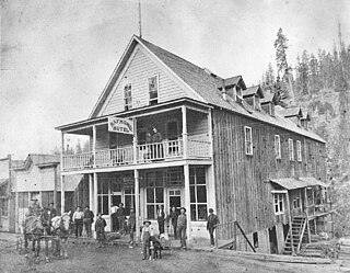
Bourne is a ghost town in Baker County, Oregon, United States about 7 miles (11 km) north of Sumpter in the Blue Mountains. It lies on Cracker Creek and is within the Wallowa–Whitman National Forest. Platted in 1902, the former gold mining boomtown is considered a ghost town today.
Nibley is an unincorporated historic community in Union County, Oregon, United States, about 11 miles east of La Grande on Oregon Route 237 in the Grande Ronde Valley.
Carson is an unincorporated community in Baker County, in the U.S. state of Oregon, along Oregon Route 413 about 5 miles (8 km) northwest of Halfway. In 1870 Tom Corson settled in the area on a tributary of Pine Creek. His neighbors pronounced his name "Carson" and named the tributary and a sawmill on the creek after him. When the post office was established in 1893, it was named "Carson" as well. The town was platted in 1900, the first in Pine Valley. The platted area was small even by northeastern standards: 12 blocks. Carson lost out as a rural service center to the nearby Langrell.