Crane Mountain

Last updated
Crane Mountain
Crane Mountain, Lake County, Oregon.jpg
West face of Crane Mountain
Highest point
Elevation 8,451 ft (2,576 m)  NAVD 88 [1]
Prominence 2,336 ft (712 m) [2]
Listing Oregon county high points
Coordinates 42°03′46″N120°14′27″W / 42.062818347°N 120.240832017°W / 42.062818347; -120.240832017 [1]
Geography
USA Oregon relief location map.svg
Red triangle with thick white border.svg
Crane Mountain
Location in Oregon
Location Lake County, Oregon, U.S.
Parent range Warner Mountains
Topo map USGS Crane Mountain
Geology
Mountain type Fault block
Climbing
Easiest route Steep rough road
Normal route Hiking trail

Crane Mountain is in the Warner Mountain range and is the tallest peak in Lake County, Oregon, U.S. It is located southeast of Lakeview in south-central Oregon, near the northwest corner of the Basin and Range Province of the western United States. The mountain is in the Fremont section of the Fremont–Winema National Forest. There was a United States Forest Service fire lookout located near the summit which was removed in 1972. [3] The Crane Mountain National Recreation Trail runs north and south along the crest of the mountain. [4]

Contents

Geography and geology

Crane Mountain is a peak near the northern end of the Warner Mountains in south-central Oregon. It is in the northwest corner of the basin and range country of the western United States. The mountain is located in the Fremont–Winema National Forest, approximately 5 miles (8.0 km) southeast of Lakeview. The summit of Crane Mountain is at 8,451 feet (2,576 m). The summit, which has a topographic prominence of 2,336 feet (712 m), is the highest point in Lake County, Oregon. [5] [6] [7] [8]

Crane Mountain is a fault-block geologic structure typical of southeast Oregon's basin and range country. The primary rock that makes up the mountain is basalt. The mountain has a west-facing fault scarp with a steep cliff face overlooking the Goose Lake Valley. The mountain's fault-block displacement tilts layers of basalt upward to expose the underlying John Day rhyolite tuff formation on the western flank of the mountain. Agates and thunder eggs are found in the rhyolite layers. Small amounts of gold bearing quartz are also found on the southern slope of the mountain. This is very unusual for an area dominated by basalt. [5] The soils around the mountain are typical of the area. They are derived primarily from broken-down basalt and tuffaceous materials. [9]

Crane Mountain is near the northern end of the Warner Mountains. The pine and fir forests of the Warner range extend north and south from Crane Mountain. [10] To the west of the mountain is the Goose Lake Valley and to the east is the Warner Valley; both are developed agricultural areas. [8] [11] [12]

The mountain is drained by five permanent creeks. Crane Creek drains the northern slopes of the mountain. The western flank of the mountain is drained by Cogswell Creek and the southwest slope by Kelley Creek. All three of these creeks flow into Goose Lake. The northeast slope is drained by Willow Creek while the east and southeast slopes are drained by Deep Creek. Both of these creeks flow into the Warner Valley, supplying the Warner Lakes system with water. [8] [13] [14]

Climate

During the summer, most days are sunny in the high-desert country around Crane Mountain. Daytime temperatures on the mountain are generally mild, but nights can be quite cool. Crane Mountain is very cold in winter, with snows beginning in November. The mountain's snowpack usually lasts through May. Annual precipitation averages 40 to 65 inches (100 to 170 cm), mostly from snowfall. This is the highest average precipitation in the Klamath Ecological Province, which includes western Lake County and southern Klamath County in south-central Oregon extending south into Siskiyou and Modoc counties in California. [5] [9]

Environment and ecology

Crane Mountain's forested northern slope Crane Mountain, Oregon (North Slope).jpg
Crane Mountain's forested northern slope

The lower and middle slopes of Crane Mountain are covered by a mixed forest. The lower elevations are dominated with ponderosa pine and some western juniper. At middle elevations, the forest is primarily ponderosa pine and western white pine with Mountain mahogany on the drier slopes. whitebark pine and subalpine fir are dominant at the higher elevations. The understory in most areas is dominated by low sagebrush. The mountain meadows have quaking aspen with wild flowers in the late spring and early summer. Among the most common wild flowers are Indian paintbrush, yellow balsamroots, phacelia, Penstemon, Clarkia, common yarrow, and spreading phlox. [5] [6] [10]

Crane Mountain and the surrounding area host a wide variety of wildlife. Larger mammals found in the area include mule deer, Rocky Mountain elk, coyotes, bobcats, and cougars. Smaller mammals include American badgers, porcupines, striped skunks, black-tailed jackrabbits, white-tailed jackrabbits, pygmy rabbits, golden-mantled ground squirrels, and least chipmunks. [5] [6] [15]

Forest birds common to the Crane Mountain area include pygmy nuthatch, juniper titmouse, mountain chickadee, blue-gray gnatcatcher, Cassin's vireo, plumbeous vireo, American dusky flycatcher, Hammond's flycatcher, olive-sided flycatcher, Vaux's swift, hermit thrush, Bullock's oriole, Woodhouse's scrub jay, Steller's jay, Clark's nutcracker, and black-billed magpie. There are also at least five woodpecker species that live on or near Crane Mountain, including the red-breasted sapsuckers, Williamson's sapsucker, black-backed woodpecker, white-headed woodpecker, and Lewis's woodpecker. Birds of prey found in the area include northern pygmy-owl, northern saw-whet owl, long-eared owl, barn owls, great gray owls, great horned owls, prairie falcon, northern harrier, northern goshawk, red-tailed hawks, turkey vultures, golden eagles, and bald eagles. [5] [15] [16]

History

In the summer of 1867, Archie McIntosh, chief Army scout for Colonel George Crook, led a group 18 of Warm Springs or Shoshone scouts on a reconnaissance patrol from Old Camp Warner south toward the Surprise Valley looking for a Paiute raiding party led by Chief Ocheho. As the patrol moved south, they picked up a fresh trail heading west into the Warner Mountains. As the patrol followed the trail up the east slope of Crane Mountain, the Paiutes ambushed McIntosh and his scouts. One scout was killed early in the fight. After some skirmishing, the Paiutes charged the scouts' position, but were repelled with a loss of three dead and several more wounded. The Paiutes then began to circle around behind the scouts, trying to cut off their escape route. To avoid being trapped, McIntosh ordered the scouts to retreat. As the scouts withdrew, the Paiutes continued to pursue them. One more Paiute warrior was killed during the retreat; however, they continued to harass the scouts all afternoon and throughout the night until the scouts reached Honey Creek, near where New Camp Warner was being built. A few days later, Colonel Crook led 360 soldiers and scouts through the Goose Lake Valley looking for the Paiutes that McIntosh had encountered. Two scouting patrols were sent to reconnoiter Crane Mountain from the west. One of the patrols found a well-built Indian fortification, but it had been abandoned. [17]

After the army drove the native people out of the area, settlers began to populate the Goose Lake Valley west of Crane Mountain. The mountain was named for Samuel Crane, an early pioneer who settled near Goose Lake at the foot of the mountain in 1869. [13] [18] Cogswell Creek was also named for an early pioneer who settled near Goose Lake, just west Crane Mountain. [14] [18]

In 1952, the Forest Service built a fire lookout tower on Crane Mountain along with a small cabin to serve as the lookout's residence. This Crane Mountain lookout was sited a short distance north of the mountain's summit at an elevation of 8,347 feet (2,544 m). It replaced an older lookout located at Willow Point, approximately 1.3 miles (2.1 km) northeast of Crane Mountain summit. [8] [19] [20] The tower was a standard treated timber CT-6 lookout with a 10-foot (3.0 m) elevation. The cabin was a one-room L-4 hip-roof structure with a 14-by-14-foot (4.3 by 4.3 m) footprint. The Willow Point garage was moved to the Crane Mountain site for the lookout's use. The total cost of building the lookout was $2,828. The cabin was renovated in 1963. After two decades of use by the Forest Service, the tower and support structures were demolished in 1972. [19] [20]

Recreation

In the summer, recreation opportunities in the Crane Mountain area include hiking, horseback riding, mountain biking, bird watching, wildlife viewing, camping, and photography. Some trails on the south side of Crane Mountain are also open to off-road vehicles. [5] [21] [22] [23] In the fall, the area around Crane Mountain is known for its excellent deer and elk hunting. [6] [24] [25] In the winter, the western slope from Kelly Creek to Cogswell Creek is available for cross-country skiing and snowshoeing, but it is a very challenging route.[ clarification needed ] Also, weather conditions on the mountain can change rapidly, especially in the winter. As a result, visitors enjoying winter activities need to check weather forecasts before setting out on any of the Crane Mountain trails. [5]

There are three day-hike trails that lead to the summit of Crane Mountain. The Crane Mountain National Recreation Trail reaches the summit from the north and the south while the Crane Mountain Summit Trail comes up the east slope of the mountain. Crane Mountain National Recreation Trail is 31 miles (50 km) long, running from the California border in the south to the point where it links up with the Fremont National Recreation Trail northeast of Lakeview. The trail is rated moderate to difficult, covering terrain that is both steep and rugged. In addition, the higher elevations near the summit of Crane Mountain normally have snow until July. As a result, the trail is lightly used. The Summit Trail begins at a parking area near the junction of forest roads 4011 and 012, 2.2 miles (3.5 km) east of the summit. [5] [22] [23] [26]

From the old lookout site near the summit of Crane Mountain, visitors have an excellent view of the Goose Lake Valley to the west as well as a number of Warner range peaks to the north and south. From the lookout station view point, visitors can see as far south as Mount Shasta and as far west as Mount McLoughlin as well as Drake Peak and Hart Mountain to the north and northeast. [7] [26]

Access

While Crane Mountain is only 10 miles (16 km) southeast of Lakeview, access to the mountain's trail system requires a 37-mile (60 km) drive to reach the trailhead for the summit hike. Much of that trip is on gravel roads. From Lakeview, head north on U.S. Route 395 for 5 miles (8.0 km), then take the exit onto Oregon Route 140. Follow Route 140 for 8 miles (13 km), past Warner Canyon Ski Area. Turn right onto Forest Road 3615, heading south. After 12 mile (0.80 km), turn west on Old Highway 140. Continue along the old highway for 1.5 miles (2.4 km), then turn south on Forest Road 3915 when the old highway ends. Follow Road 3915 for approximately 9 miles (14 km) and then turn right on Forest Road 4011. After 2.5 miles (4.0 km) turn onto Forest Road 012, where there is a parking area 14 mile (0.40 km) from the turnoff. The Crane Mountain Summit Trail begins there. If one continues on Road 4011 past the Road 012 junction, the road leads to the top of Crane Mountain. However, the road is extremely steep and rough. [8] [21] [26]

See also

Related Research Articles

<span class="mw-page-title-main">Lake County, Oregon</span> County in Oregon, United States

Lake County is one of the 36 counties in the U.S. state of Oregon. As of the 2020 census, the population was 8,160. Its county seat is Lakeview. The county is named after the many lakes found within its boundaries, including Lake Abert, Summer Lake, Hart Lake, and Goose Lake.

<span class="mw-page-title-main">Lakeview, Oregon</span> Town in Oregon, United States

Lakeview is a town in Lake County, Oregon, United States. The population was 2,418 at the 2020 census. It is the county seat of Lake County. The city bills itself as the "Tallest Town in Oregon" because of its elevation, 4,757 feet (1,450 m) above sea level. Lakeview is situated in the Goose Lake Valley at the foot of the Warner Mountains and at the edge of Oregon's high desert country. Its economy is based on agriculture, lumber production, and government activities. In addition, tourism is an increasingly important part of the city's economy. Oregon's Outback Scenic Byway passes through Lakeview.

<span class="mw-page-title-main">Warner Mountains</span> Mountain range in California and Oregon, United States

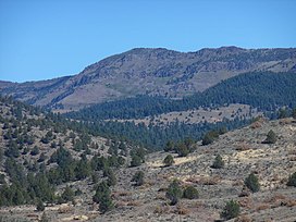
The Warner Mountains are an 85-mile (137 km)-long mountain range running north–south through northeastern California and extending into southern Oregon in the United States. The range lies within the northwestern corner of the Basin and Range Province, extending from the northeastern corner of Lassen County, California, through eastern Modoc County, California, and northward into Lake County, Oregon.

<span class="mw-page-title-main">Fremont–Winema National Forest</span> Protected area in the U.S. state of Oregon

The Fremont–Winema National Forest is a United States National Forest formed from the 2002 merger of the Fremont and Winema National Forests. They cover territory in southern Oregon from the crest of the Cascade Range on the west past the city of Lakeview to the east. The northern end of the forests is bounded by U.S. Route 97 on the west and Oregon Route 31 on the east. To the south, the state border with California forms the boundary of the forests. Klamath Falls is the only city of significant size in the vicinity. The forests are managed by the United States Forest Service, and the national forest headquarters are located in Lakeview.

<span class="mw-page-title-main">Sky Lakes Wilderness</span>

The Sky Lakes Wilderness is a wilderness area located in the Rogue River–Siskiyou and Fremont–Winema national forests in the southern Cascade Range of Oregon in the United States. It comprises 116,300 acres (47,100 ha), of which 75,695 acres (30,633 ha) are in the Rogue River–Siskiyou National Forest and 40,605 acres (16,432 ha) are in the Fremont–Winema National Forest. It was established in 1984 under the Wilderness Act of 1964.

<span class="mw-page-title-main">Yamsay Mountain</span> Shield volcano mountain in Oregon, U.S.

Yamsay Mountain is a large shield volcano in the Cascade Range of south-central Oregon, located about 35 miles (56 km) east of Crater Lake on the border between Klamath County and Lake County. It is part of the Cascade Volcanic Arc but is located in a mountain range 30 to 50 miles behind the main Cascade volcanic front. The best known members of this enigmatic arc are the massive shields of Newberry Volcano, about 55 miles (89 km) farther north in Oregon, and Medicine Lake Volcano, about 80 miles (130 km) south in Northern California. Yamsay is the highest volcano in the eastern arc, almost 300 feet (90 m) higher than Newberry and Medicine Lake.

<span class="mw-page-title-main">Mountain Lakes Wilderness</span> Protected wilderness area in Oregon, United States

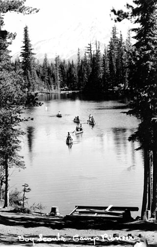
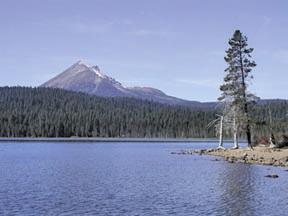
The Mountain Lakes Wilderness is a wilderness area located in the Fremont–Winema National Forest in the southern Cascade Range of Oregon in the United States. It surrounds a cluster of four overlapping shield volcanoes, the highest of which is 8,208-foot (2,502 m) Aspen Butte. Over 20 small lakes lie along the bottoms of several large cirques carved by Ice Age glaciers near the summits of the volcanoes.

<span class="mw-page-title-main">Chandler State Wayside</span> State Park in lake County, Oregon

Chandler State Wayside is a state park in south-central Oregon in the United States. It is named in honor of Solomon and Hattie Chandler, who donated the land for the park. The park covers 85 acres (34 ha) of pine forest along a creek. The park provides restrooms and other basic facilities to accommodate the traveling public. Chandler State Wayside is administered by the Oregon Parks and Recreation Department.

<span class="mw-page-title-main">Gearhart Mountain Wilderness</span> Protected natural area in the U.S. state of Oregon

Gearhart Mountain Wilderness is a wilderness area located within the Fremont–Winema National Forest in Lake County and Klamath County in south-central Oregon. This area was established in 1943 as a Wild Area and designated as wilderness with the Wilderness Act of 1964. In 1984, an additional 4,144 acres (1,677 ha) were added for a total of 22,823 acres (9,236 ha). The wilderness is entirely within the Bly Ranger District.

<span class="mw-page-title-main">Wood River (Oregon)</span> River in Oregon, United States

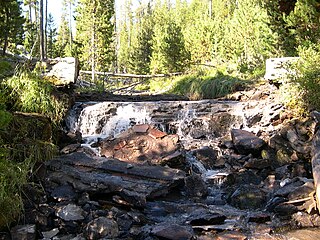
The Wood River is a short river in the southern region of the U.S. state of Oregon, and part of the Klamath Basin drainage. It flows 18 miles (29 km) through the Fremont-Winema National Forests, Bureau of Land Management land, and private property in southern Oregon. Its watershed consists of 220 square miles (570 km2) of conifer forest, rural pasture land, and marsh. The river provides habitat for many species of wildlife including an adfluvial (migratory) and resident populations of native Great Basin redband trout.

<span class="mw-page-title-main">Camp Warner</span> Former military outpost in Oregon, USA

Camp Warner was a United States Army outpost in south-central Oregon, United States. Camp Warner was located at two different sites approximately 35 miles (56 km) apart. The Army called both sites Camp Warner. However, the first site became known as Old Camp Warner. It was used as winter quarters in 1866–1867 and then abandoned. The second, more developed site is generally known as Fort Warner, although the Army never officially designated it as a fort. Fort Warner was used as a supply depot and administrative headquarters from 1867 to 1874 during a protracted Army campaign against Northern Paiute bands in Eastern Oregon and Northern California. Today, nothing remains of either Old Camp Warner or Fort Warner.

<span class="mw-page-title-main">Warner Valley</span> Valley in south-central Oregon

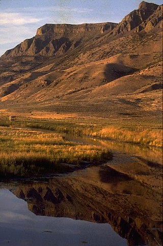
The Warner Valley is a valley in south-central Oregon in the United States. It is a remote valley at the northwestern corner of North America's Basin and Range Province. The valley is home to a chain of lakes and wetlands known as the Warner Lakes. Native Americans were present in the Warner Valley for thousands of years before European explorers arrived in the 19th century. It is the site of Fort Warner, built by the United States Army in 1867. The fort was used as a supply depot and administrative headquarters during a protracted Army campaign against Northern Paiute bands in eastern Oregon and northern California. Today, livestock ranching is the main commercial activity in the valley. The Warner Valley offers a number of recreational opportunities including hunting, fishing, bird watching, and wildlife viewing.

<span class="mw-page-title-main">Warner Lakes</span> Endorheic lake in Oregon, United States

The Warner Lakes are a chain of shallow lakes and marshes in the Warner Valley of eastern Lake County, Oregon, United States. The lakes extend the length of the valley, covering approximately 90,000 acres (360 km2).

<span class="mw-page-title-main">Goose Lake Valley</span> Valley in south-central Oregon and northeastern California

The Goose Lake Valley is located in south-central Oregon and northeastern California in the United States. It is a high valley at the northwestern corner of North America's Great Basin. Much of the valley floor is covered by Goose Lake, a large endorheic lake that straddles the Oregon–California border. Native Americans inhabited the Goose Lake Valley for thousands of years before explorers arrived in the 19th century. The pioneer wagon route known as the Applegate Trail crossed the Goose Lake Valley on its way to southern Oregon. At the south end of Goose Lake, the Lassen Cutoff separated from the Applegate Trail and headed south toward the Sacramento Valley. Today, Lakeview, Oregon, is the largest settlement in the valley. Livestock ranching and lumber mills are the valley's main commercial activity. The Goose Lake Valley offers a number of recreational opportunities including hang-gliding, hunting, fishing, and birdwatching.

<span class="mw-page-title-main">Lake of the Woods (Oregon)</span> Lake in Oregon, United States

Lake of the Woods is a natural lake near the crest of the Cascade Range in the Fremont–Winema National Forest in southern Oregon in the United States. The lake covers 1,146 acres (4.64 km2). It was named by Oliver C. Applegate in 1870. Today, the Oregon Department of Fish and Wildlife manages the lake's fishery. The small unincorporated community of Lake of the Woods is located on the east shore of the lake. Lake of the Woods is one of southern Oregon's most popular outdoor recreation sites.

<span class="mw-page-title-main">Hager Mountain</span>

Hager Mountain is a volcanic peak in Oregon in the northwest corner of the Basin and Range Province in the United States. The mountain is located south of the small unincorporated community of Silver Lake in south-central Oregon, and it is in the Fremont–Winema National Forest. On the summit, there is a fire lookout operated during the summer and fall by the United States Forest Service. There are several hiking trails that lead to the lookout station.

<span class="mw-page-title-main">Barry Point Fire</span> 2012 wildfire in Oregon and California

The Barry Point Fire was a wildfire that burned over 92,977 acres (376.26 km2) of Oregon and California forest land during the summer of 2012. The fire began on 5 August 2012, the result of a lightning strike. The fire consumed public forest and rangeland as well as private forest and grazing land located in Lake County, Oregon and Modoc County, California. The public lands affected by the fire are administered by the United States Forest Service and the Oregon Department of Forestry. The largest part of the private land was owned by the Collins Timber Company. At the peak of the firefighting effort, there were 1,423 personnel working on the fire. It took 22 days to fully contain the fire and then an additional three weeks to mop it up.

<span class="mw-page-title-main">Crump Lake (Oregon)</span> Natural lake in Oregon, US

Crump Lake is a shallow lake in the Warner Valley of eastern Lake County, Oregon, United States. The lake covers 7,680 acres (31.1 km2). It is the largest of the Warner Lakes system. The lake is named for pioneer rancher Thomas Crump. Crump Lake is owned by the Oregon Department of State Lands. Much of the land around the lake is administered by the Bureau of Land Management and the United States Fish and Wildlife Service. The lake and the surrounding wetlands support a wide variety of birds and other wildlife. Recreational opportunities on or near Crump Lake include fishing, bird watching, and camping.

Quartz Mountain is an unincorporated community in Lake County in the U.S. state of Oregon. It lies in the Fremont–Winema National Forest along Oregon Route 140 between Bly and Lakeview. Quartz Creek, a tributary of Drews Creek, which feeds Goose Lake, flows through the community.

<span class="mw-page-title-main">High Cascades Complex fires</span> Series of forest fires in Oregon

The High Cascades Complex was a group of 20 fires burning in four protected areas in Oregon, in the United States, specifically: Crater Lake National Park, Rogue River – Siskiyou National Forest, Umpqua National Forest, and Fremont–Winema National Forest. The first fire in the complex, the Blanket Creek Fire, was started by a lightning strike on July 29, 2017. In total, the fires have burned 72,309 acres (293 km2) and are 28% contained. The fires are directly impacting the communities of Prospect, Union Creek and Diamond Lake, park headquarters, old growth forests that house endangered species like the spotted owl and volcanic features.

References

  1. 1 2 "Crane". NGS Data Sheet. National Geodetic Survey, National Oceanic and Atmospheric Administration, United States Department of Commerce . Retrieved 2016-04-12.
  2. "Crane Mountain, Oregon". Peakbagger.com. Retrieved 2016-04-12.
  3. "Crane Mountain Lookout Site". Forest Fire Lookout Association. Archived from the original on 2016-03-04.
  4. "Crane Mountain National Recreation Trail #161". Fremont-Winema National Forest . Retrieved 2016-05-01.
  5. 1 2 3 4 5 6 7 8 9 Sullivan, William L. (1994). Exploring Oregon's Wild Areas (2 ed.). Seattle, Washington: The Mountaineers. pp. 256–257. ISBN   978-0898863864.
  6. 1 2 3 4 "California-Oregon border backcountry mule deer of the Warner Mountains" (pdf), "Backcountry Borderlands Safeguarding Sportsmen's Interests Across State Lines", Theodore Roosevelt Conservation Partnership, Washington, District of Columbia, accessed June 6, 2015.
  7. 1 2 "Crane Mountain", SummitPost, www.summitpost.org, accessed June 5, 2015.
  8. 1 2 3 4 5 Oregon topographic map, United States Geological Survey, United States Department of Interior, Reston, Virginia; displayed via ACME mapper, www.acme.com, June 4, 2015.
  9. 1 2 Anderson, E. William, Michael M. Borman, and William C. Krueger, "Klamath Ecological Province" Archived 2016-03-04 at the Wayback Machine , The Ecological Provinces of Oregon, Department of Rangeland Resources and Management, Oregon State University, 1997.
  10. 1 2 "Table Two – Bird Habitat Conservation Areas by Ecoregion" (pdf), "Coordinated Implementation Plan for Bird Conservation in Eastern Oregon", Oregon Working Group, Eastern Oregon Habitat Joint Venture, West Linn, Oregon, 2005, p. 24.
  11. Johnson, Daniel M., "Goose Lake" (pdf), Atlas of Oregon Lakes, Oregon State University Press, Corvallis, Oregon, June 1, 1985, p. 86.
  12. Whistler, John T. and John H. Lewis, "Transportation and Markets", Warner Valley and White River Projects, United States Reclamation Service, United States Department of Interior in cooperation with the State of Oregon, Washington D.C., February 1916, p. 19.
  13. 1 2 McArthur, Lewis A. and Lewis L. McArthur, "Crane Creek", Oregon Geographic Names (Seventh Edition), Oregon Historical Society Press: Portland, Oregon, 2003, p. 245.
  14. 1 2 McArthur, Lewis A. and Lewis L. McArthur, "Cogswell Creek", Oregon Geographic Names (Seventh Edition), Oregon Historical Society Press: Portland, Oregon, 2003, p. 216.
  15. 1 2 "Wildlife list for Crane Creek" Archived 2014-10-26 at the Wayback Machine , Oregon Wildlife Explorer, National Resources Digital Library, Oregon State University Libraries, Oregon State University, Corvallis, Oregon, accessed December 10, 2014.
  16. Miller, Craig, Scott Carpenter, et al, "Lake County Birding Locations" [ permanent dead link ], Birding Sites in Oregon, East Cascades Audubon Society, Bend, Oregon, accessed May 15, 2015.
  17. Michno Gregory, "Crane Mountain, August 25, 1867", "The Deadliest Indian War in the West: The Snake Conflict, 1864–1868", Caxton Press, Caldwell, Idaho, 2007, pp. 243–244.
  18. 1 2 Shaver, F. A., et al, An Illustrated History of Central Oregon Embracing Wasco, Sherman, Gilliam Wheeler, Crook, Lake, and Klamath Counties State Of Oregon, Western Historical Publishing Company, Spokane, Washington, 1905, p. 816.
  19. 1 2 "Crane Mountain Lookout Site" Archived 2016-03-04 at the Wayback Machine , Former Fire Lookout Site Register, Forest Fire Lookout Association, Vienna, Virginia, accessed April 28, 2015.
  20. 1 2 Kresek, Ray E., Fire Lookouts of the Northwest (Third Edition), Historic Lookout Project, Spokane, Washington, Ye Galleon Press, 1998.
  21. 1 2 "Crane Mountain Trailhead", United States Forest Service, United States Department of Agriculture, Fremont-Winema National Forest, Lakeview, Oregon, accessed April 28, 2015.
  22. 1 2 "Crane Mountain National Recreation Trail #161", United States Forest Service, United States Department of Agriculture, Fremont-Winema National Forest, Lakeview, Oregon, accessed April 28, 2015.
  23. 1 2 "Crane Mountain National Recreation Trail", Travel Oregon, Oregon Tourism Commission, Salem, Oregon, accessed May 8, 2015.
  24. "Bag Big Buck", The News-Review, Roseburg, Oregon, September 23, 1933, p. 3.
  25. Faris, Irwin, "New Pine Creek", Herald and News, Klamasth Falls, Oregon, October 10, 1950, p. 14.
  26. 1 2 3 Lorain, Douglas, "Crane Mountain", 100 Classic Hikes in Oregon: Oregon Coast, Columbia Gorge, Cascades, Eastern Oregon, Wallowas, The Mountaineers Books, Seattle, Washington, 2011, pp. 231–232.