
John Charles Frémont was an American explorer, military officer, and politician. He was a United States senator from California and was the first Republican nominee for president of the U.S. in 1856 and founder of the California Republican Party when he was nominated. He lost the election to Democrat James Buchanan when the vote was split by Know Nothings.

Lakeview is a town in Lake County, Oregon, United States. The population was 2,418 at the 2020 census. It is the county seat of Lake County. The city bills itself as the "Tallest Town in Oregon" because of its elevation, 4,757 feet (1,450 m) above sea level. Lakeview is situated in the Goose Lake Valley at the foot of the Warner Mountains and at the edge of Oregon's high desert country. Its economy is based on agriculture, lumber production, and government activities. In addition, tourism is an increasingly important part of the city's economy. Oregon's Outback Scenic Byway passes through Lakeview.
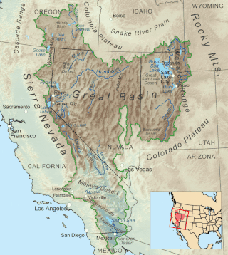
The Great Basin is the largest area of contiguous endorheic watersheds, those with no outlets to the ocean, in North America. It spans nearly all of Nevada, much of Utah, and portions of California, Idaho, Oregon, Wyoming, and Baja California. It is noted for both its arid climate and the basin and range topography that varies from the North American low point at Badwater Basin in Death Valley to the highest point of the contiguous United States, less than 100 miles (160 km) away at the summit of Mount Whitney. The region spans several physiographic divisions, biomes, ecoregions, and deserts.

The Mojave River is an intermittent river in the eastern San Bernardino Mountains and the Mojave Desert in San Bernardino County, California, United States. Most of its flow is underground, while its surface channels remain dry most of the time, except for the headwaters and several bedrock gorges in the lower reaches.

South Pass is a route across the Continental Divide, in the Rocky Mountains in southwestern Wyoming. It lies in a broad high region, 35 miles (56 km) wide, between the nearly 14,000 ft (4,300 m) Wind River Range to the north and the over 8,500 ft (2,600 m) Oregon Buttes and arid, saline near-impassable Great Divide Basin to the south. The Pass lies in southwestern Fremont County, approximately 35 miles (56 km) SSW of Lander.

The Sweetwater River is a 238-mile (383 km) long tributary of the North Platte River, in the U.S. state of Wyoming. As a part of the Mississippi River system, its waters eventually reach the Gulf of Mexico.

Independence Rock is a large granite rock, approximately 130 feet (40 m) high, 1,900 feet (580 m) long, and 850 feet (260 m) wide, which is in southwestern Natrona County, Wyoming along Wyoming Highway 220. During the middle of the 19th century, it formed a prominent and well-known landmark on the Oregon, Mormon, and California emigrant trails. Many of these emigrants carved their names on it, and it was described by early missionary and explorer Father Pierre-Jean De Smet in 1840 as the Register of the Desert. The site was designated a National Historic Landmark on January 20, 1961 and is now part of Independence Rock State Historic Site, owned and operated by the state of Wyoming.

Mountain Springs is an unincorporated community in Clark County in southern Nevada. It is located in Mountain Springs Summit, the pass over the Spring Mountains through which Highway 160 connects Las Vegas and Pahrump. Public buildings include a fire house and a saloon.
The Fremont–Winema National Forest is a United States National Forest formed from the 2002 merger of the Fremont and Winema National Forests. They cover territory in southern Oregon from the crest of the Cascade Range on the west past the city of Lakeview to the east. The northern end of the forests is bounded by U.S. Route 97 on the west and Oregon Route 31 on the east. To the south, the state border with California forms the boundary of the forests. Klamath Falls is the only city of significant size in the vicinity. The forests are managed by the United States Forest Service, and the national forest headquarters are located in Lakeview.

The Sky Lakes Wilderness is a wilderness area located in the Rogue River–Siskiyou and Fremont–Winema national forests in the southern Cascade Range of Oregon in the United States. It comprises 116,300 acres (47,100 ha), of which 75,695 acres (30,633 ha) are in the Rogue River–Siskiyou National Forest and 40,605 acres (16,432 ha) are in the Fremont–Winema National Forest. It was established in 1984 under the Wilderness Act of 1964.

The Mount Thielsen Wilderness is a wilderness area located on and around Mount Thielsen in the southern Cascade Range of Oregon in the United States. It is located within the Deschutes, Umpqua, and Fremont–Winema national forests. It was established by the United States Congress in 1984 and comprises 55,100 acres (22,300 ha).

Yamsay Mountain is a large shield volcano in the Cascade Range of south-central Oregon, located about 35 miles (56 km) east of Crater Lake on the border between Klamath County and Lake County. It is part of the Cascade Volcanic Arc but is located in a mountain range 30 to 50 miles behind the main Cascade volcanic front. The best known members of this enigmatic arc are the massive shields of Newberry Volcano, about 55 miles (89 km) farther north in Oregon, and Medicine Lake Volcano, about 80 miles (130 km) south in Northern California. Yamsay is the second highest volcano in the eastern arc, almost 300 feet (90 m) higher than Newberry and Medicine Lake.

The Mountain Lakes Wilderness is a wilderness area located in the Fremont–Winema National Forest in the southern Cascade Range of Oregon in the United States. It surrounds a cluster of four overlapping shield volcanoes, the highest of which is 8,208-foot (2,502 m) Aspen Butte. Over 20 small lakes lie along the bottoms of several large cirques carved by Ice Age glaciers near the summits of the volcanoes.

Gearhart Mountain Wilderness is a wilderness area located within the Fremont–Winema National Forest in Lake County and Klamath County in south-central Oregon. This area was established in 1943 as a Wild Area and designated as wilderness with the Wilderness Act of 1964. In 1984, an additional 4,144 acres (1,677 ha) were added for a total of 22,823 acres (9,236 ha). The wilderness is entirely within the Bly Ranger District.

The Wood River is a short river in the southern region of the U.S. state of Oregon, and part of the Klamath Basin drainage. It flows 18 miles (29 km) through the Fremont-Winema National Forests, Bureau of Land Management land, and private property in southern Oregon. Its watershed consists of 220 square miles (570 km2) of conifer forest, rural pasture land, and marsh. The river provides habitat for many species of wildlife including an adfluvial (migratory) and resident populations of native Great Basin redband trout.

The Goose Lake Valley is located in south-central Oregon and northeastern California in the United States. It is a high valley at the northwestern corner of North America's Great Basin. Much of the valley floor is covered by Goose Lake, a large endorheic lake that straddles the Oregon–California border. Native Americans inhabited the Goose Lake Valley for thousands of years before explorers arrived in the 19th century. The pioneer wagon route known as the Applegate Trail crossed the Goose Lake Valley on its way to southern Oregon. At the south end of Goose Lake, the Lassen Cutoff separated from the Applegate Trail and headed south toward the Sacramento Valley. Today, Lakeview, Oregon, is the largest settlement in the valley. Livestock ranching and lumber mills are the valley's main commercial activity. The Goose Lake Valley offers a number of recreational opportunities including hang-gliding, hunting, fishing, and birdwatching.

Hager Mountain is a volcanic peak in Oregon in the northwest corner of the Basin and Range Province in the United States. The mountain is located south of the small unincorporated community of Silver Lake in south-central Oregon, and it is in the Fremont–Winema National Forest. On the summit, there is a fire lookout operated during the summer and fall by the United States Forest Service. There are several hiking trails that lead to the lookout station.

The Barry Point Fire was a wildfire that burned over 92,977 acres (376.26 km2) of Oregon and California forest land during the summer of 2012. The fire began on 5 August 2012, the result of a lightning strike. The fire consumed public forest and rangeland as well as private forest and grazing land located in Lake County, Oregon and Modoc County, California. The public lands affected by the fire are administered by the United States Forest Service and the Oregon Department of Forestry. The largest part of the private land was owned by the Collins Timber Company. At the peak of the firefighting effort, there were 1,423 personnel working on the fire. It took 22 days to fully contain the fire and then an additional three weeks to mop it up.

Crane Mountain is in the Warner Mountain range and is the tallest peak in Lake County, Oregon, U.S. It is located southeast of Lakeview in south-central Oregon, near the northwest corner of the Basin and Range Province of the western United States. The mountain is in the Fremont section of the Fremont–Winema National Forest. There was a United States Forest Service fire lookout located near the summit which was removed in 1972. The Crane Mountain National Recreation Trail runs north and south along the crest of the mountain.

The High Cascades Complex was a group of 20 fires burning in four protected areas in Oregon, in the United States, specifically: Crater Lake National Park, Rogue River – Siskiyou National Forest, Umpqua National Forest, and Fremont–Winema National Forest. The first fire in the complex, the Blanket Creek Fire, was started by a lightning strike on July 29, 2017. In total, the fires have burned 72,309 acres (293 km2) and are 28% contained. The fires are directly impacting the communities of Prospect, Union Creek and Diamond Lake, park headquarters, old growth forests that house endangered species like the spotted owl and volcanic features.