| Round Butte Dam | |
|---|---|
| Location | Jefferson County, Oregon, U.S. |
| Coordinates | 44°36′11″N121°16′40″W / 44.60306°N 121.27778°W |
| Opening date | 1964 [1] |
| Construction cost | $62 million |
| Operator(s) | Portland General Electric Co [1] |
| Dam and spillways | |
| Impounds | Deschutes River |
| Height | 440 feet (130 m) [1] |
| Length | 1,450 feet (442 m) [1] |
| Width (base) | 1,570 feet (480 m) |
| Reservoir | |
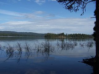
| Creates | Lake Billy Chinook |
| Total capacity | 535,000 acre-feet (0.660 km3) [1] |
| Catchment area | 7,514 square miles (19,500 km2) [1] |
| Surface area | 4,000 acres (16.2 km2) [1] |
| Power Station | |
| Installed capacity | 367 MW |
Round Butte Dam is a rockfill-type hydroelectric dam on the Deschutes River, in the U.S. state of Oregon.
Located in Jefferson County and owned by the power company Portland General Electric, its reservoir is called Lake Billy Chinook.
The dam was completed in 1965 after three years of construction. More than 10 million tons of earth-fill were used to create this 440-foot tall, 1,320-foot wide, and 1,570-foot thick at the base storage dam. [2]

The Deschutes River in central Oregon is a major tributary of the Columbia River. The river provides much of the drainage on the eastern side of the Cascade Range in Oregon, gathering many of the tributaries that descend from the drier, eastern flank of the mountains. The Deschutes provided an important route to and from the Columbia for Native Americans for thousands of years, and then in the 19th century for pioneers on the Oregon Trail. The river flows mostly through rugged and arid country, and its valley provides a cultural heart for central Oregon. Today the river supplies water for irrigation and is popular in the summer for whitewater rafting and fishing.

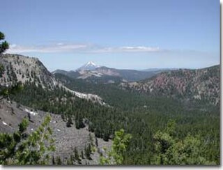
Mount Jefferson is a stratovolcano in the Cascade Volcanic Arc, part of the Cascade Range in the U.S. state of Oregon. The second highest mountain in Oregon, it is situated within Linn County, Jefferson County, and Marion County and forms part of the Mount Jefferson Wilderness. Due to the ruggedness of its surroundings, the mountain is one of the hardest volcanoes to reach in the Cascades. It is also a popular tourist destination despite its remoteness, with recreational activities including hiking, backpacking, mountaineering, and photography. Vegetation at Mount Jefferson is dominated by Douglas fir, silver fir, mountain hemlock, ponderosa pine, lodgepole pine, and several cedar species. Carnivores, insectivores, bats, rodents, deer, birds, and various other species inhabit the area.

Three Fingered Jack is a summit of a shield volcano of the Cascade Range in the U.S. state of Oregon. Formed during the Pleistocene epoch, the mountain consists mainly of basaltic andesite lava and was heavily glaciated in the past. While other Oregon volcanoes that were heavily glaciated—such as Mount Washington and Mount Thielsen—display eroded volcanic necks, Three Fingered Jack's present summit is a comparatively narrow ridge of loose tephra supported by a dike only 10 feet (3.0 m) thick on a generally north–south axis. Glaciation exposed radiating dikes and plugs that support this summit. The volcano has long been inactive and is highly eroded.

Central Oregon is a geographic region in the U.S. state of Oregon and is traditionally considered to be made up of Deschutes, Jefferson, and Crook counties. Other definitions include larger areas, often encompassing areas to the north towards the Columbia River, eastward towards Burns, or south towards Klamath Falls. These three counties have a combined population of 200,431 as of the 2010 census, with Deschutes the largest of the three counties, having approximately four times the population of the other two counties combined. As of 2015, the most populous city in the region is Bend, with an estimated 87,014 residents. As defined by the three county definition, Central Oregon covers 7,833 square miles (20,290 km2) of land. Central Oregon has had 3 record tourism years beginning in 2012. Over 2.2 million people visited Central Oregon in 2012 and again in 2013.

Lava Butte is a cinder cone in central Oregon, United States, just west of U.S. Route 97 between the towns of Bend, and Sunriver in Deschutes County. It is part of a system of small cinder cones on the northwest flank of Newberry Volcano, a massive shield volcano which rises to the southeast. The cinder cone is capped by a crater which extends about 60 feet (20 m) deep beneath its south rim, and 160 feet (50 m) deep from the 5,020-foot (1,530 m) summit on its north side. Lava Butte is part of the Newberry National Volcanic Monument.

Olallie Scenic Area is a United States Forest Service designated scenic area located in Oregon's Cascade Range. It is between Mount Hood on the north and Mount Jefferson to the south and contains Olallie Lake along with several smaller lakes. The name Olallie is Chinook Jargon for berry. Olallie Lake is open to vehicle traffic June to September. There is no cellphone service.
Aspen Butte is a steep-sided shield volcano in the Cascade Range of southern Oregon. It is located 15 miles (24 km) south of Pelican Butte and 15 miles (24 km) southeast of Mount McLoughlin. It rises over 4,000 feet (1,200 m) above the nearby shore of Upper Klamath Lake. Ice Age glaciers carved three large cirques into the north and northeast flanks of the mountain removing most of the original summit area including any evidence of a crater. The summit is now the high point along the curving ridge which bounds the southern edge of the cirques above steep cliffs.
The Mountain Lakes Wilderness is a wilderness area located in the Fremont–Winema National Forest in the southern Cascade Range of Oregon in the United States. It surrounds a cluster of four overlapping shield volcanoes, the highest of which is 8,208-foot (2,502 m) Aspen Butte. Over 20 small lakes lie along the bottoms of several large cirques carved by Ice Age glaciers near the summits of the volcanoes.
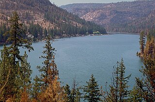
The Cove Palisades State Park is a state park in eastern Jefferson County, Oregon, near Culver and Madras in the central part of the state, and is administered by the Oregon Parks and Recreation Department. It is located on the waters and surrounding lands of Lake Billy Chinook, an impoundment of the Crooked, Deschutes, and Metolius rivers.

The Crooked River is a tributary, 125 miles (201 km) long, of the Deschutes River in the U.S. state of Oregon. The river begins at the confluence of the South Fork Crooked River and Beaver Creek. Of the two tributaries, the South Fork Crooked River is the larger and is sometimes considered part of the Crooked River proper. A variant name of the South Fork Crooked River is simply "Crooked River". The Deschutes River flows north into the Columbia River.

Clear Lake is a mountain lake 53 miles (85 km) southeast of Portland, Oregon, United States in Mount Hood National Forest. It can be seen from flights in the region as a bird-shaped body of water.

Crested Butte is a prominent mountain summit in the Elk Mountains range of the Rocky Mountains of North America. The 12,168-foot (3,709 m) peak is in Gunnison National Forest, 2.1 miles (3.4 km) northeast by east of the Town of Crested Butte in Gunnison County, Colorado, United States. Ski lifts and runs of the Crested Butte Mountain Resort occupy the north side of the mountain.
Howard Prairie Lake is a reservoir located 4,526 feet (1,380 m) above sea level in Jackson County, Oregon, United States. It is 18 miles (29 km) east of Ashland. The lake is formed by the 100-foot (30 m) tall Howard Prairie Dam, which impounds Beaver Creek, in the Klamath River watershed.

Hat Rock State Park is a state park in the U.S. state of Oregon, administered by the Oregon Parks and Recreation Department. The park is located off the east side of U.S. Highway 730 in Hermiston, on the south shore of Lake Wallula behind McNary Dam on the Columbia River.

Agate Lake is a reservoir located 1,510 feet (460 m) above sea level in Jackson County, Oregon, United States. It is 13 miles (21 km) northeast of Medford, just north of Roxy Ann Peak. The lake is formed by the 86-foot (26 m) tall Agate Dam, which impounds Dry Creek, in the Rogue River watershed.

Little Butte Creek is a 17-mile-long (27 km) tributary of the Rogue River in the U.S. state of Oregon. Its drainage basin consists of approximately 354 square miles (917 km2) of Jackson County and another 19 square miles (49 km2) of Klamath County. Its two forks, the North Fork and the South Fork, both begin high in the Cascade Range near Mount McLoughlin and Brown Mountain. They both flow generally west until they meet near Lake Creek. The main stem continues west, flowing through the communities of Brownsboro, Eagle Point, and White City, before finally emptying into the Rogue River about 3 miles (5 km) southwest of Eagle Point.

Fish Lake is a reservoir located 4,639 feet (1,414 m) above sea level in Jackson County, Oregon, United States. It is 35 miles (56 km) northeast of Medford. Originally a natural lake, it was enlarged by the 50-foot (15 m) tall Fish Lake Dam, which impounds the north fork of Little Butte Creek, in the Rogue River watershed.

Big Butte Creek is a 12-mile-long (19 km) tributary of the Rogue River in the U.S. state of Oregon. It drains approximately 245 square miles (635 km2) of Jackson County. Its two forks, the North Fork and the South Fork, both begin high in the Cascade Range near Mount McLoughlin. Flowing predominantly west, they meet near the city of Butte Falls. The main stem flows generally northwest until it empties into the Rogue Falls was incorporated in 1911, and remains the only incorporated town within the watershed's boundaries.

Pelton Dam is a major dam on the Deschutes River in Jefferson County, Oregon, owned and operated as a hydroelectric facility by Portland General Electric, one element of its Pelton Round Butte Project on the Deschutes.
| Authority control databases: Geographic |
|---|
| | This article about a building or structure in Oregon is a stub. You can help Wikipedia by expanding it. |
| | This article about a hydroelectric power plant is a stub. You can help Wikipedia by expanding it. |