Wallowa Lake, Oregon

Last updated

Wallowa Lake, Oregon
Wallowa Lake Lodge (23981010948).jpg
Wallowa Lake Lodge
USA Oregon location map.svg
Red pog.svg
Wallowa Lake, Oregon
Location within Oregon
Coordinates: 45°18′15″N117°12′42″W / 45.30417°N 117.21167°W / 45.30417; -117.21167
Country United States
State Oregon
County Wallowa
Area
[1]
  Total4.00 sq mi (10.36 km2)
  Land1.83 sq mi (4.75 km2)
  Water2.17 sq mi (5.61 km2)
Elevation
[2]
4,380 ft (1,340 m)
Population
 (2020) [3]
  Total72
  Density39.26/sq mi (15.16/km2)
Time zone UTC-8 (Pacific (PST))
  Summer (DST) UTC-7 (PDT)
FIPS code 41-78160
GNIS feature ID2584429 [2]

Wallowa Lake is a census-designated place (CDP) and unincorporated community in Wallowa County, Oregon, United States. It is located on the south end of Wallowa Lake, and is a small community made up of vacation homes, lodging, restaurants, as well as other small businesses.

Contents

History

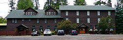
Wallowa Lake gained popularity among gold miners and soon began attracting guests from other areas. Seeing an emerging tourism market, entrepreneurs began building businesses at the lake. Among those built was the Wonderland Inn, now known as the Wallowa Lake Lodge. The Wonderland Inn was developed in 1923 as an amusement park at the south end of the lake. The park contained a restaurant, store, bowling alley, dance hall, outdoor movie theater, horse drawn carousel and cabins for those wishing to stay overnight. An 18-passenger boat carried the guests who arrived in Joseph (which lies at the north end of the lake) down the entire four mile stretch of Wallowa Lake, finally arriving at the inn and amusement park.

The amusement park operated until 1940, when snowfall from an unusually harsh winter crushed most of the buildings and rendered the park inoperable. However, the inn survived the winter and still remains in operation, though renamed the Wallowa Lake Lodge. [4] The area at the south end of the lake continued to be developed commercially. Several more stores, lodges, restaurants, and rental cabins were built in the following years, turning the south end of the lake into a tourist community.

The businesses at the south end of Wallowa Lake are members of a non-profit tourism association. This association maintains a website, supports tourism in the area and works to solve issues across the lake community.

There are 2,000 to 3,000 people residing at the south end of Wallowa Lake in summer with all businesses open. However, from October through March there are less than 40 year-round residences at the south end of the lake, and only a few lodging businesses remain open.

Demographics

Historical population
CensusPop.Note
2020 72
U.S. Decennial Census [5] [3]

As of the census of 2010, there were 62 people, 37 households, and 19 families residing in the CDP. The racial makeup of the CDP was 96.8% White (95.2% non-Hispanic White) 1.6% Native American, and 1.6% from two or more races (White and Asian). Hispanic or Latino of any race were 1.6% of the population. [6]

There were 37 households, of which 0.0% had children under the age of 18 living with them, 48.6% were married couples living together, 2.7% had a female householder with no husband present, 0.0% had a male householder with no wife present, and 48.6% were non-families. 43.2% of all households were made up of individuals, and 29.7% had someone living alone who was 65 years of age or older. The average household size was 1.68 and the average family size was 2.21. [6]

The median age in the city was 64.5 years. 0.0% of residents were under the age of 18; 0.0% were between the ages of 18 and 24; 4.8% were from 25 to 44; 45.2% were from 45 to 64; and 50.1% were 65 years of age or older. The gender makeup of the CDP was 46.8% male and 53.2% female. [6]

Related Research Articles

<span class="mw-page-title-main">Wallowa County, Oregon</span> County in Oregon, United States

Wallowa County is the northeastern most county in the U.S. state of Oregon. As of the 2020 census, the population was 7,391, making it Oregon's fifth-least populous county. Its county seat is Enterprise. According to Oregon Geographic Names, the origins of the county's name are uncertain, with the most likely explanation being it is derived from the Nez Perce term for a structure of stakes used in fishing. An alternative explanation is that Wallowa is derived from a Nez Perce word for "winding water". The journals of Lewis and Clark Expedition record the name of the Wallowa River as Wil-le-wah.

<span class="mw-page-title-main">Cooper Landing, Alaska</span> Census-designated place in Alaska, United States

Cooper Landing is a census-designated place (CDP) in Kenai Peninsula Borough, Alaska, United States, about 100 miles (160 km) south of Anchorage, at the outlet of Kenai Lake into the Kenai River. The town was first settled in the 19th century by gold and mineral prospectors, and has become a popular summer tourist destination thanks to its scenic location and proximity to the salmon fishery of the Kenai River and Russian River. As of the 2010 census, the population in Cooper Landing was 289, down from 369 in 2000.

<span class="mw-page-title-main">Glenwood, Arkansas</span> City in Arkansas, United States

Glenwood is a city in Pike and Montgomery counties in Arkansas, United States. As of the 2020 census, its population was 2,068. The community is located along the Caddo River in the Ouachita Mountains.

<span class="mw-page-title-main">Cameron Park, California</span> CDP in California, United States

Cameron Park is a census-designated place (CDP) in El Dorado County, California, United States and is part of the Greater Sacramento Area. The population was 19,171 in the 2020 census, up from 18,228 in 2010. Cameron Park is a community located in the Northern California Gold Country of the Sierra Nevada foothills, approximately 30 miles (50 km) east of Sacramento and 70 miles (110 km) west of South Lake Tahoe.

<span class="mw-page-title-main">Chester, California</span> Census-designated place in California, United States

Chester is a census-designated place (CDP) in Plumas County, California, United States. Chester is located on Lake Almanor, 30 miles (48.3 km) north-northwest of Quincy. The town is located along State Route 36. The US Postal Service ZIP code for the community is 96020. The population was 2,144 at the 2010 census, down from 2,316 at the 2000 census.

<span class="mw-page-title-main">Lake Arrowhead, California</span> Census-designated place in California, United States

Lake Arrowhead is an unincorporated community and a census-designated place (CDP) in the San Bernardino Mountains of San Bernardino County, California, surrounded by the San Bernardino National Forest, and surrounding the eponymous Lake Arrowhead Reservoir. Lake Arrowhead is located 13 miles north east of the San Bernardino city limits. The population of the CDP was estimated at 12,424 in the 2010 census. It was formerly called "Little Bear Lake", until around 1920, when a group from Los Angeles, the Arrowhead Lake Company, bought the lake and the land surrounding it, and changed its name to Arrowhead Lake.

<span class="mw-page-title-main">Boyes Hot Springs, California</span> Census designated place in California, United States

Boyes Hot Springs is a census-designated place (CDP) in Sonoma Valley, Sonoma County, California, United States. The population was 6,656 people at the 2010 census. Resorts in Boyes Hot Springs, El Verano, Fetters Hot Springs, and Agua Caliente were popular health retreats for tourists from San Francisco and points beyond until the middle of the 20th century because of the geothermic hot springs that still well up from deep within the Earth.

Pleasure Ridge Park is a former census-designated place (CDP) in southwest Jefferson County, Kentucky, United States. The population was 26,212 at the 2010 census. In 2003, the area was annexed to the city of Louisville due to a merger between the city and Jefferson County's unincorporated communities. Pleasure Ridge Park is now said to be a neighborhood within the city limits of Louisville by local media.

<span class="mw-page-title-main">Paw Paw Lake, Michigan</span> Census-designated place & unincorporated community in Michigan, United States

Paw Paw Lake is an unincorporated community in Berrien County in the U.S. state of Michigan. It is a census-designated place (CDP) for statistical purposes, without legal status as a municipality. The community is located within areas of both Coloma Charter Township and Watervliet Township in the area surrounding Paw Paw Lake and Little Paw Paw Lake, excluding the cities of Watervliet and Coloma. The population of the CDP was 3,511 at the 2010 census.

<span class="mw-page-title-main">Haslett, Michigan</span> Census-designated place in Michigan, United States

Haslett is a census-designated place (CDP) in Ingham County in the U.S. state of Michigan. It is located mostly within Meridian Charter Township with a small portion extending east into Williamstown Township. The population was 19,220 at the 2010 census. Haslett contains its own school district, as well as its own post office with the 48840 ZIP Code.

Niverville is a semi-rural hamlet and census-designated place (CDP) in northern Columbia County, New York, United States. The hamlet of Niverville is located in the town of Kinderhook, south of Kinderhook Lake. The Niverville CDP includes the hamlet as well as all of the land surrounding Kinderhook Lake, extending east into the town of Chatham. The population of the CDP was 1,662 at the 2010 census.

<span class="mw-page-title-main">Orange Lake, New York</span> CDP in New York, United States

Orange Lake is a hamlet in Orange County, New York, United States. The population was 9,770 at the 2020 census. It is part of the Newburgh–Middletown, NY Metropolitan Statistical Area as well as the larger New York–Newark–Bridgeport, NY-NJ-CT-PA Combined Statistical Area.

<span class="mw-page-title-main">Smallwood, New York</span> CDP & hamlet in New York, United States

Smallwood is a hamlet in Sullivan County, New York, United States. The population was 839 at the 2020 census.

<span class="mw-page-title-main">Geneva-on-the-Lake, Ohio</span> Village in Ohio, United States

Geneva-on-the-Lake is a village in northwestern Ashtabula County, Ohio, United States, along the southern shore of Lake Erie. A small resort town, the population was 916 at the 2020 census. It is part of the Ashtabula micropolitan area, 46 miles (74 km) northeast of Cleveland.

<span class="mw-page-title-main">Callicoon (CDP), New York</span> CDP in New York, United States

Callicoon is a hamlet and census-designated place in the Town of Delaware, Sullivan County, New York, United States. The population was 206 at the 2020 census.

<span class="mw-page-title-main">Brookdale, California</span> Census-designated place in California, United States

Brookdale is a census-designated place (CDP) in Santa Cruz County, California. Brookdale sits at an elevation of 405 feet (123 m). It is located in the San Lorenzo Valley between Boulder Creek and Ben Lomond on Highway 9. The 2010 United States census reported Brookdale's population was 1,991.

<span class="mw-page-title-main">Groveland, California</span> Census-designated place in California, United States

Groveland is a census-designated place (CDP) in Tuolumne County, California. Groveland sits at an elevation of 3,136 feet (956 m). The 2020 United States census reported Groveland's population was 540.

<span class="mw-page-title-main">Wallowa Lake</span>

Wallowa Lake is a ribbon lake 1 mile (1.6 km) south of Joseph, Oregon, United States, at an elevation of 4,372 ft (1,333 m). Impounded by high moraines, it was formed by a series of Pleistocene glaciers. On the south end of the lake is a small community made up of vacation homes, lodging, restaurants, as well as other small businesses. Wallowa Lake has been used for recreation since at least 1880. The Wallowa Lake State Park is at the southern tip of the lake.

<span class="mw-page-title-main">June Lake, California</span> Census-designated place in California, United States

June Lake is an unincorporated community and census-designated place (CDP) in Mono County, California, United States. It is located against the southern rim of the Mono Basin, 12.5 miles (20 km) south of Lee Vining, at an elevation of 7,654 feet (2,333 m).

Paradise is an unincorporated community and census-designated place (CDP) that is the southernmost community in Mono County, California, United States. The population was 174 at the 2020 census.

References

  1. "ArcGIS REST Services Directory". United States Census Bureau. Retrieved October 12, 2022.
  2. 1 2 U.S. Geological Survey Geographic Names Information System: Wallowa Lake, Oregon
  3. 1 2 "Census Population API". United States Census Bureau. Retrieved October 12, 2022.
  4. "History of the Wallowa Lake Lodge". Archived from the original on December 1, 1998. Retrieved March 8, 2023.
  5. "Census of Population and Housing". Census.gov. Retrieved June 4, 2016.
  6. 1 2 3 "U.S. Census website". United States Census Bureau . Retrieved June 26, 2017.