
Lostine is a city in Wallowa County, Oregon, United States. The population was 213 at the 2010 census.

Wallowa is a city in Wallowa County, Oregon, United States. The population was 808 at the 2010 census.

The Wallowa River is a tributary of the Grande Ronde River, approximately 55 miles (89 km) long, in northeastern Oregon in the United States. It drains a valley on the Columbia Plateau in the northeast corner of the state north of Wallowa Mountains.

Minam is an unincorporated community in northwestern Wallowa County, Oregon, United States. It is located at the confluence of the Minam and Wallowa rivers, north of the Wallowa Mountains on Oregon Route 82. Minam is approximately 20 miles (32 km) Northeast of La Grande.

Goshen is an unincorporated community in Lane County, Oregon, United States. It is located at the junction of Oregon Route 58, Oregon Route 99, and Interstate 5.
Alicel is an unincorporated community in the Sand Ridge area of the Grande Ronde Valley in Union County, Oregon, United States. It is northeast of La Grande on Oregon Route 82. It was a station on Union Pacific Railroad's Joseph branch, and in 1890 was named for Alice Ladd, wife of local resident Charles Ladd. Alicel was platted in 1890, and had a post office from 1890 until 1972.
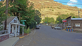
Imnaha is an unincorporated community at the confluence of Big Sheep Creek and the Imnaha River in Wallowa County, Oregon, United States. Its elevation is 1,978 feet (603 m). Oregon Route 350 connects Imnaha to the nearest incorporated city, Joseph, 30 miles (48 km) to the west. Imnaha is best known as the gateway to the Hat Point scenic lookout on Hells Canyon at the Snake River.

McEwen is an unincorporated community in Baker County, Oregon, United States. McEwen lies on Oregon Route 7 east of its interchange with Oregon Route 410. McEwen is about 6 miles (10 km) southeast of Sumpter along the Powder River.

Homestead is an unincorporated community in Baker County, in the U.S. state of Oregon. Homestead lies on the Snake River south of Hells Canyon National Recreation Area and about 4 miles (6 km) north of Copperfield and Oxbow.

Catherine Creek is a 32.4-mile-long (52.1 km) creek in northeastern Oregon, United States. A tributary of the Grande Ronde River, it is the second-longest stream in the Grande Ronde Valley. Originating in the foothills of the Wallowa Mountains, it flows generally northwest through Catherine Creek State Park and the city of Union before joining the river.
Paradise is an unincorporated community in Wallowa County, Oregon, United States, about three miles east of Oregon Route 3 and about six miles south of the Oregon-Washington border. It is located on a plateau that overlooks Joseph Canyon. The closest incorporated cities are Enterprise, Oregon and Asotin, Washington at 40 and 45 miles away, respectively. Its elevation is 4114 feet.
Orodell, also known as Oro Dell, is an unincorporated historic community in Union County, Oregon, United States, on the Grande Ronde River at the northwest edge of La Grande. It is considered a ghost town. Either Charles Fox or Stephen Coffin started the first sawmill in the Grande Ronde Valley there in the summer of 1862, after a joint-stock company between Coffin and other local settlers failed to materialize in 1861.
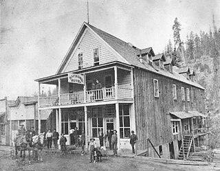
Bourne is a ghost town in Baker County, Oregon, United States about 7 miles (11 km) north of Sumpter in the Blue Mountains. It lies on Cracker Creek and is within the Wallowa–Whitman National Forest. Platted in 1902, the former gold mining boomtown is considered a ghost town today.

Lancaster is an unincorporated community in Lane County, Oregon, United States. It is located about two miles south of Harrisburg and two miles north of Junction City, on Oregon Route 99E near the Willamette River.
Provolt is an unincorporated community in Jackson County, Oregon, United States. It is about 15 miles (24 km) southeast of Grants Pass on Oregon Route 238, near the Applegate River on the county line between Jackson and Josephine counties.
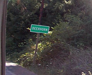
Deerhorn is an unincorporated community in Lane County, Oregon, United States. It is about 4 miles (6 km) west of Leaburg on Oregon Route 126 in the McKenzie River valley.
Cecil is an unincorporated community in Morrow County, Oregon, United States. It is about 14 miles (23 km) northwest of Ione, on Oregon Route 74. The Oregon Trail crossed Willow Creek here, and it was once an important stagecoach stop.

Thatcher is an unincorporated historic community in Washington County, Oregon, United States. It was located approximately three miles north of Forest Grove at the intersection of Hillside and Thatcher roads. The area is part of the Forest Grove Rural Fire Protection District.
Kamela is an unincorporated community in Union County, Oregon, United States. It is located west of Interstate 84 about 20 miles northwest of La Grande.
Brownsboro is an unincorporated community in Jackson County, Oregon, United States, on Oregon Route 140 about 4 miles (6 km) east of Eagle Point.


