Related Research Articles

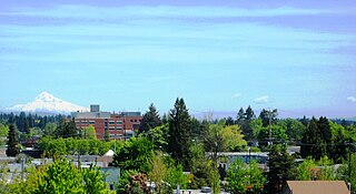
Portland is a city of regional importance to the Pacific Northwest and the largest city in the U.S. state of Oregon. Within Oregon it is the county seat of Multnomah County, the largest county in Oregon by population. It is also an inland port city in the Willamette Valley region of the Pacific Northwest, at the confluence of the Willamette and Columbia rivers in Northwestern Oregon. As of 2020, Portland had a population of 652,503, making it the 25th-most populated city in the United States, the sixth-most populous on the West Coast, and the second-most populous in the Pacific Northwest, after Seattle. Approximately 2.5 million people live in the Portland metropolitan statistical area (MSA), making it the 25th most populous in the United States. Its combined statistical area (CSA) ranks 19th-largest with a population of around 3.2 million. Approximately 47% of Oregon's population resides within the Portland metropolitan area.

Beaverton is a city in Washington County, in the U.S. state of Oregon that is located 7 miles (11 km) west of Portland in the Tualatin Valley. The city is among the main cities that make up the Portland metropolitan area. Its population was 97,494 at the 2020 census, making it the second-largest city in the county and the seventh-largest city in Oregon. Beaverton is an economic center for Washington County along with neighboring Hillsboro. It is home to the world headquarters of Nike, Inc., although it sits outside of city limits on unincorporated county land.

Oregon City is the county seat of Clackamas County, Oregon, United States, located on the Willamette River near the southern limits of the Portland metropolitan area. As of the 2020 census, the city population was 37,572. Established in 1829 by the Hudson's Bay Company, in 1844 it became the first U.S. city west of the Rocky Mountains to be incorporated.
Hillsboro is the fifth-largest city in the U.S. state of Oregon and is the county seat of Washington County. Situated in the Tualatin Valley on the west side of the Portland metropolitan area, the city hosts many high-technology companies, such as Intel, locally known as the Silicon Forest. At the 2020 Census, the city's population was 106,447.

Wilsonville is a city primarily in Clackamas County, Oregon, United States. A portion of the northern section of the city is in Washington County. It was founded as Boones Landing because of the Boones Ferry which crossed the Willamette River at the location; the community became Wilsonville in 1880. The city was incorporated in 1969 with a population of approximately 1,000. The population was 13,991 at the 2000 census, and grew to 19,509 as of 2010. Slightly more than 90% of residents at the 2000 census were white, with Hispanics comprising the largest minority group.

Portland International Airport is a joint civil–military airport and the largest airport in the U.S. state of Oregon, accounting for 90% of the state's passenger air travel and more than 95% of its air cargo. It is within Portland's city limits just south of the Columbia River in Multnomah County, 6 miles by air and 12 mi (19 km) by highway northeast of downtown Portland. Portland International Airport is often referred to by its IATA airport code, PDX. The airport covers 3,000 acres of land.
Oregon Health & Science University (OHSU) is a public research university focusing primarily on health sciences with a main campus, including two hospitals, in Portland, Oregon. The institution was founded in 1887 as the University of Oregon Medical Department and later became the University of Oregon Medical School. In 1974, the campus became an independent, self-governed institution called the University of Oregon Health Sciences Center, combining state dentistry, medicine, nursing, and public health programs into a single center. It was renamed Oregon Health Sciences University in 1981 and took its current name in 2001, as part of a merger with the Oregon Graduate Institute (OGI), in Hillsboro. The university has several partnership programs including a joint PharmD Pharmacy program with Oregon State University in Corvallis.

John Elwood "Bud" Clark Jr. was an American politician and businessman who served as the 48th mayor of Portland, Oregon from 1985 to 1992. A left-leaning populist with little political experience before his mayoral bid, he was one of Portland's most colorful political figures.

The MAX Yellow Line is a light rail service in Portland, Oregon, United States, operated by TriMet as part of the MAX Light Rail system. It connects North Portland to Portland City Center and Portland State University (PSU) with 17 stops from Expo Center station to PSU South/Southwest 6th and College station. The line travels from Portland Expo Center in the north, south to the Rose Quarter through a 5.8-mile (9.3 km) light rail segment along the median of Interstate Avenue. From the Rose Quarter, it crosses the Willamette River via the Steel Bridge and enters downtown Portland, where it operates as a northbound-only service of the Portland Transit Mall on 6th Avenue. Service runs for approximately 21 hours daily with a headway of 15 minutes during most of the day.

Downtown Portland is the city center of Portland, Oregon, United States. It is on the west bank of the Willamette River in the northeastern corner of the southwest section of the city and where most of the city's high-rise buildings are found.

Old Town Chinatown is the official Chinatown of the Northwest section of Portland, Oregon. The Willamette River forms its eastern boundary, separating it from the Lloyd District and the Kerns and Buckman neighborhoods. It includes the Portland Skidmore/Old Town Historic District and the Portland New Chinatown/Japantown Historic District, which are listed on the National Register of Historic Places. It has been referred to as the "skid row" of Portland.
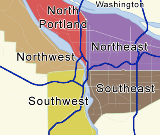
Portland, Oregon is divided into six sections: North Portland, Northeast Portland, Northwest Portland, South Portland, Southeast Portland, and Southwest Portland. There are 95 officially recognized neighborhoods, each of which is represented by a volunteer-based neighborhood association. No neighborhood associations overlap the Willamette River, but a few overlap the addressing sextants. For example, most addresses in the South Portland Neighborhood Association are South, but a portion of the neighborhood is west of SW View Point Terrace where addresses have a SW prefix. Similarly the Buckman Neighborhood Association spans both NE and SE Portland.
The following list presents the full set of National Register of Historic Places listings in Multnomah County, Oregon. However, please see separate articles for listings in each of Portland's six quadrants.

Vancouver is a city on the north bank of the Columbia River in the U.S. state of Washington, located in Clark County. Incorporated in 1857, Vancouver has a population of 190,915 as of the 2020 census, making it the fourth-largest city in Washington state. Vancouver is the county seat of Clark County and forms part of the Portland-Vancouver metropolitan area, the 25th-largest metropolitan area in the United States. Originally established in 1825 around Fort Vancouver, a fur-trading outpost, the city is located on the Washington–Oregon border along the Columbia River, directly north of Portland, and is considered a suburb of the city along with its surrounding areas.
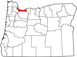
Northwest Portland is one of the sextants of Portland, Oregon.

The Alder Street food cart pod was a pod of food carts at the intersection of Southwest 10th Avenue and Alder Street in Portland, Oregon.
References
- ↑ Templeton, Amelia (June 6, 2018). "South Portland Becomes City's Newest Address Area". OPB. Archived from the original on June 12, 2018. Retrieved June 6, 2018.
- ↑ Aebi, Andrew; Russ, Don. "South Portland Addressing Project: Wayfinding, 9-1-1 Dispatching & Emergency Response Improvements". www.portlandoregon.gov. Archived from the original on 28 June 2021. Retrieved 28 June 2021.
 | ||
| | This Oregon-related article is a stub. You can help Wikipedia by expanding it. |