
Portland is a port city in the Pacific Northwest and the most populous city in the U.S. state of Oregon. Situated in the northwestern area of the state at the confluence of the Willamette and Columbia rivers, Portland is the county seat of Multnomah County, the most populous county in Oregon. As of 2020, Portland had a population of 652,503, making it the 26th-most populated city in the United States, the sixth-most populous on the West Coast, and the second-most populous in the Pacific Northwest, after Seattle. Approximately 2.5 million people live in the Portland–Vancouver–Hillsboro, OR–WA metropolitan statistical area, making it the 25th most populous in the United States. About half of Oregon's population resides within the Portland metropolitan area.

Klickitat Street is a city street located in northeast Portland, Oregon, United States. The main stem of the street is 3.75-mile (6.04 km) long, and runs east-west parallel to—and one block south of—northeast Fremont Street, from the eastern edge of Irving Park to Northeast 67th Avenue. Additional disconnected segments are east of Rocky Butte from 105th to 117th, 148th to 154th, and 163rd to 165th. A segment named Klickitat Court is between 135th and 140th.
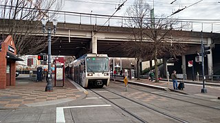
Rose Quarter Transit Center is a light rail station in the MAX system and a TriMet bus transit center, and is located in the Rose Quarter area of Portland, Oregon, a part of the Lloyd District. It is served by the Blue, Green and Red Lines. It is currently the 7th stop eastbound on the Eastside MAX as well as the first stop after crossing the Willamette River on the Steel Bridge. Two hundred yards west of the station is the Interstate/Rose Quarter station on the MAX Yellow Line.

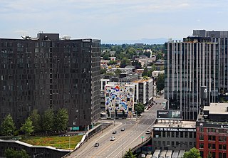
Downtown Portland is the central business district of Portland, Oregon, United States. It is on the west bank of the Willamette River in the northeastern corner of the southwest section of the city and where most of the city's high-rise buildings are found.

Old Town Chinatown is the official Chinatown of the northwest section of Portland, Oregon. The Willamette River forms its eastern boundary, separating it from the Lloyd District and the Kerns and Buckman neighborhoods. It includes the Portland Skidmore/Old Town Historic District and the Portland New Chinatown/Japantown Historic District, which are listed on the National Register of Historic Places. It has been referred to as the "skid row" of Portland.

The Burnside Triangle, also known as Pink Triangle or Vaseline Alley, was a triangular district in Portland, Oregon, United States, known for its relatively higher density of LGBT and gay-friendly businesses.
Alameda is a neighborhood in Portland, Oregon, United States that is located on the Alameda Ridge with views of Downtown, the Willamette River, and the Cascades. Northeast Fremont Street is the neighborhood's main east-west thoroughfare and NE 33rd, its main north-south thoroughfare, makes up its eastern boundary.

Irvington is a neighborhood in the Northeast section of Portland, Oregon. According to the city's Office of Community and Civic Life, it consists of a rectangular area extending east to west from NE 7th Ave. to NE 26th Ave., and north to south from NE Fremont St. to NE Broadway. It borders the King, Sabin, and Alameda neighborhoods to the north; Alameda and Grant Park to the east; Sullivan's Gulch and the Lloyd District to the south; and Eliot to the west.

Grant Park refers to both a neighborhood and public park in the Northeast section of Portland, Oregon. The neighborhood is bordered by Alameda and Beaumont-Wilshire to the north; Rose City Park to the east; Hollywood District, Laurelhurst, and Sullivan's Gulch to the south; and Irvington to the west.

The Lloyd District is a primarily commercial neighborhood in the North and Northeast sections of Portland, Oregon. It is named after Ralph Lloyd (1875–1953), a California rancher, oilman, and real estate developer who moved to and started the development of the area.
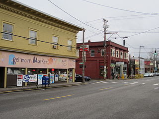
The Belmont Area is a retail and residential district running along SE Belmont St. in the inner Southeast section of Portland, Oregon in a parallel fashion to the Hawthorne District, 6 blocks to the south. From west to east the area extends 48 blocks, from SE 12th Ave. to SE 60th Ave., passing through the Buckman, Sunnyside, and Mount Tabor neighborhoods. The area is seven blocks wide, running from SE Belmont St. 4 blocks north to SE Stark St. and 3 blocks south to SE Salmon St. SE Belmont St. between SE 33rd Ave. and SE 35th Ave., in Sunnyside, is the heart of the district.

Sullivan's Gulch is a neighborhood in the Northeast section of Portland, Oregon. The name commemorates Timothy Sullivan, an early farmer in the area. Sullivan settled his donation land claim on January 27, 1851. He was born in Ireland in 1805, received citizenship in the United States in 1855, and most likely received title to the claim around 1863.
Sabin is a neighborhood in the Northeast section of Portland, Oregon, United States. It is bordered by Vernon on the north, King on the west, Irvington on the south, Alameda on the east, and Concordia on the northeast.
Kerns is a neighborhood in the inner Northeast and Southeast sections of Portland, Oregon. It borders the Lloyd District and Sullivan's Gulch on the north, Laurelhurst on the east, Buckman and Sunnyside on the south, and Old Town Chinatown on the west.
Blossoming Lotus is a counter-service vegan restaurant in Portland, Oregon, U.S. It was founded in Kapa'a, Hawaii, in 2002. At its peak the company had three restaurants, but now only operates in Portland at 2 locations, a Northeast Restaurant, and a Northwest Cafe and Juice Bar.

The Alameda Ridge is a large gravel bar located in Portland, Oregon, United States. It forms a ridgeline above much of north and southeast Portland, with views of downtown and west side neighborhoods. Alameda Ridge runs through the Madison South, Roseway, Rose City Park, Beaumont-Wilshire, Alameda, and Sabin neighborhoods.
The Burnside Bridgehead is a development project at the northeast end of the Burnside Bridge in Portland, Oregon's Kerns neighborhood, in the United States.
Northwest Portland is one of the sextants of Portland, Oregon, United States.

Cadillac Cafe is a restaurant in Portland, Oregon's Irvington neighborhood, in the United States.

