Punch Bowl Falls

Last updated
Punch Bowl Falls
Punch Bowl Falls.jpg
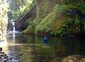
Punch Bowl Falls on May 11, 2005.
USA Oregon relief location map.svg
Red pog.svg
Usa edcp relief location map.png
Red pog.svg
Punch Bowl Falls
Coordinates 45°37′19″N121°53′36″W / 45.62183°N 121.89325°W / 45.62183; -121.89325
Type Punchbowl
Total height35 feet (11 m)
Total width10 feet (3.0 m)
Watercourse Eagle Creek

Punch Bowl Falls is a waterfall on Eagle Creek in the Columbia River Gorge National Scenic Area, Oregon, United States. Eagle Creek drains into the Columbia River, with its outlet on the Columbia River Gorge in Multnomah County.

Contents

The falls is 35 feet (11 m) tall and 10 feet (3.0 m) wide. Eagle Creek cuts through a narrow channel and shoots powerfully into a large bowl that resembles a punchbowl. This waterfall was responsible for the waterfall classification type of punchbowl.

These falls are not to be confused with another set of falls with the same name, found in Jasper National Park, Alberta, Canada near Miette Hot Springs.

In 2017, the cliff on the left side of the creek collapsed between Punch Bowl and Lower Punch Bowl Falls. Debris from the landslide changed the stream's flow between waterfalls.

A little up the river, there is a dilapidated wooden staircase leading to a concrete fish ladder.

Nearby waterfalls

See also


Related Research Articles

<span class="mw-page-title-main">Yosemite Falls</span> Waterfall in California, United States

Yosemite Falls is the highest waterfall in Yosemite National Park, dropping a total of 2,425 feet (739 m) from the top of the upper fall to the base of the lower fall. Located in the Sierra Nevada of California, it is a major attraction in the park, especially in late spring when the water flow is at its peak.

<span class="mw-page-title-main">Columbia River Gorge</span> Canyon along the border of Oregon and Washington in the United States

The Columbia River Gorge is a canyon of the Columbia River in the Pacific Northwest of the United States. Up to 4,000 feet (1,200 m) deep, the canyon stretches for over eighty miles (130 km) as the river winds westward through the Cascade Range, forming the boundary between the state of Washington to the north and Oregon to the south. Extending roughly from the confluence of the Columbia with the Deschutes River in the east down to the eastern reaches of the Portland metropolitan area, the water gap furnishes the only navigable route through the Cascades and the only water connection between the Columbia Plateau and the Pacific Ocean. It is thus that the routes of Interstate 84, U.S. Route 30, Washington State Route 14, and railroad tracks on both sides run through the gorge.

<span class="mw-page-title-main">Multnomah Falls</span> Waterfall in Oregon, U.S.

Multnomah Falls is a waterfall located on Multnomah Creek in the Columbia River Gorge, east of Troutdale, between Corbett and Dodson, Oregon, United States. The waterfall is accessible from the Historic Columbia River Highway and Interstate 84. Spanning two tiers on basalt cliffs, it is the tallest waterfall in the state of Oregon at 620 ft (189 m) in height. The Multnomah Creek Bridge, built in 1914, crosses below the falls, and is listed on the National Register of Historic Places.

<span class="mw-page-title-main">Fall Creek Falls State Park</span> State park in Tennessee, United States

Fall Creek Falls State Resort Park is a state park in Van Buren and Bledsoe counties, in the U.S. state of Tennessee. The over 30,638-acre (123.99 km2) park is centered on the upper Cane Creek Gorge, an area known for its unique geological formations and scenic waterfalls. The park's namesake is the 256-foot (78 m) Fall Creek Falls, the highest free-fall waterfall east of the Mississippi River.

<span class="mw-page-title-main">Oneonta Gorge</span> Waterfall in Oregon, United States

Oneonta Gorge is a scenic gorge located in the Columbia River Gorge area of the American state of Oregon. The U.S. Forest Service has designated it as a botanical area because of the unique aquatic and woodland plants that grow there. Exposed walls of 25-million-year-old basalt are home to a wide variety of ferns, mosses, hepatics, and lichens, many of which grow only in the Columbia River Gorge. Oneonta Gorge with its 50 species of wildflowers, flowering shrubs and trees has been described as "one of the true dramatic chasms in the state." The Oneonta Gorge Creek Bridge is listed on the National Register of Historic Places.

<span class="mw-page-title-main">Bridal Veil Falls (Oregon)</span> Waterfall located in Oregon, United States

The Bridal Veil Falls is a waterfall located on Bridal Veil Creek along the Columbia River Gorge in Multnomah County, Oregon, United States. The waterfall is accessible from the historic Columbia River Highway and Interstate 84. Spanning two tiers on basalt cliffs, it is the only waterfall which occurs below the historic Columbia Gorge Scenic Highway. The Bridal Veil Falls Bridge, built in 1914, crosses over the falls, and is listed on the National Register of Historic Places.

<span class="mw-page-title-main">Latourell Falls</span> Waterfall in Oregon, United States

Latourell Falls is a waterfall along the Columbia River Gorge in the U.S. state of Oregon, within Guy W. Talbot State Park.

<span class="mw-page-title-main">Eagle Creek (Columbia River tributary)</span> River in Oregon, United States

Eagle Creek is a creek located mainly in Hood River County, Oregon, in the Columbia River Gorge, with its last roughly 0.5 miles (0.80 km) and mouth in Multnomah County. A tributary of the Columbia River, the creek flows for approximately 15 miles (24 km) from the Thrush Pond between Eagle Butte and Tanner Butte to its mouth near Bonneville Dam. The East Fork Eagle Creek is a major tributary that begins at Wahtum Lake and joins the main stem approximately 2/3 the way between the Thrush Pond and the Columbia River, separated by Indian Mountain.

<span class="mw-page-title-main">Mark O. Hatfield Wilderness</span>

The Mark O. Hatfield Wilderness is a wilderness area located on the northern side of Mount Hood in the northwestern Cascades of the U.S. state of Oregon, near the Columbia River Gorge and within Mount Hood National Forest. Prior to Wilderness designation it was known as the Columbia Gorge Recreation Area.

<span class="mw-page-title-main">Linville Falls</span> Waterfall in Burke County, North Carolina

Linville Falls is a waterfall located in the Blue Ridge Mountains of North Carolina in the United States. The falls move in several distinct steps, beginning in a twin set of upper falls, moving down a small gorge, and culminating in a high-volume 45-foot (14 m) drop.

<span class="mw-page-title-main">Wahclella Falls</span> Waterfall in Oregon, United States

Wahclella Falls is a waterfall along Tanner Creek, a tributary of the Columbia River, Multnomah County, Oregon, United States. It enters the river within the Columbia River Gorge.

<span class="mw-page-title-main">Metlako Falls</span> Waterfall in Oregon, United States

Metlako Falls is a waterfall on Eagle Creek in the Columbia River Gorge National Scenic Area in Hood River County, Oregon, United States. It is the furthest downstream of the major waterfalls on Eagle Creek. Like upstream Punch Bowl Falls, Metlako is also in the form of a punchbowl. The falls is 31 meters (101 ft) tall, though people have measured it anywhere from 30 to 46 m tall. It is the upstream limit for salmon spawning in Eagle Creek.

Multnomah Creek is a 5-mile-long (8.0 km) stream in northern Oregon. Multnomah Creek's source is on Larch Mountain in the Mount Hood National Forest and its waters flow north to the Columbia River Gorge, over Multnomah Falls into Benson Lake and then the Columbia River. The waterfall is accessible from the Historic Columbia River Highway and Interstate 84. The two drop waterfall is the tallest in the state of Oregon at 620 ft (189 m) in height.

<span class="mw-page-title-main">Devil's Punch Bowl (Hamilton, Ontario)</span> Waterfall in Hamilton, Ontario

Devil's Punch Bowl is a 37-metre ribbon waterfall on the Niagara Escarpment, in the Stoney Creek community of Hamilton, Ontario, Canada. It is found in the Devil's Punchbowl Conservation Area, maintained by the Hamilton Conservation Authority, and features an escarpment access trail with connections to a recently improved section of the Bruce Trail. Stoney Creek's Dofasco 2000 Trail is nearby. The Punch Bowl is also known as Horseshoe Falls for the distinctive shape of the cliff-face, which somewhat resembles its much larger cousin in Niagara Falls.

A punch bowl is a vessel in which punch is served.

Wy'east Falls is a waterfall on a small tributary of Eagle Creek in Hood River County, Oregon, U.S.

<span class="mw-page-title-main">Van Trump Creek</span> River in Washington, United States

Van Trump Creek, also called Van Trump Falls Creek or the Van Trump Fork of the Nisqually River, is a creek in Pierce County, Washington. It is a tributary of the Nisqually River, joining the river just above the mouth of the Paradise River. The creek is known for having several well known waterfalls along its course.

<span class="mw-page-title-main">Eagle Creek waterfalls</span>

Eagle Creek is a tributary of the Columbia River in Multnomah and Hood River counties in the U.S. state of Oregon. It cuts through a narrow canyon in its 3,200 feet (980 m) descent to the Columbia River Gorge and is known for its concentration of 13 waterfalls in about 5 miles (8.0 km) distance. Eight major falls are on Eagle Creek and the East Fork Eagle Creek itself, while five are on its tributaries.

The Paradise River in Washington state, United States, is known for having a total of eight major waterfalls.

Tanner Creek is a creek located in the Columbia River Gorge in Multnomah County, Oregon, United States, that is a tributary of the Columbia River.