The Nestucca River flows for about 57 miles (92 km) through forests near the Pacific coast of northwest Oregon in the United States. It drains a timber-producing area of the Northern Oregon Coast Range west of Portland.

The Delta River is an 80-mile (130 km) tributary of the Tanana River in the U.S. state of Alaska. Its name in the Ahtna language is Saas Na’ . Fed by the Tangle Lakes of the Alaska Range, the river flows north to meet the larger river near Big Delta.

The Niobrara National Scenic River is in north-central Nebraska, United States, approximately 300 miles (480 km) northwest of Omaha. In 1991, Congress set aside 76 miles (120 km) for preservation under the management of the National Park Service with assistance from the local Niobrara Council. Several "outstandingly remarkable values" have been designated to be protected along the Niobrara National Scenic River, including: Fish and Wildlife, Scenery, Fossil Resources, Geology, and Recreation. The river was designated by Backpacker magazine as one of the 10 best rivers for canoeing in the United States.

The Kettle is an 83.6-mile-long (134.5 km) tributary of the St. Croix River in eastern Minnesota in the United States. Via the St. Croix River, it is part of the watershed of the Mississippi River. The river's English name is due to the large number of large rounded holes (kettles) in the sandstone in and around the river, carved out by the swirling waters of the river. The river's Dakota name Céġa watpa entered into English via the Anishinaabe people's Akiko-ziibi, both meaning "Kettle River".
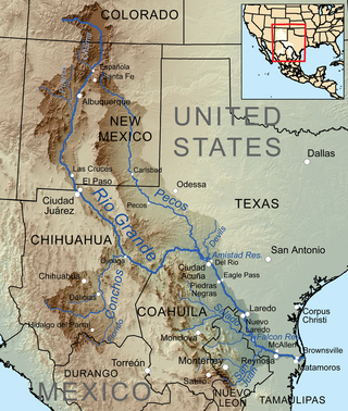
The Devils River in southwestern Texas, part of the Rio Grande drainage basin, has limited areas of whitewater along its length. It begins in northwest Sutton County, at 30°19′40″N100°56′31″W, where six watercourses come together, Dry Devils River, Granger Draw, House Draw, Jackson, Flat Rock Draw, and Rough Canyon. It flows southwest for 94 miles (151 km) through Val Verde County and empties into the northeastern shore of the Amistad Reservoir, an impoundment of the Rio Grande near Del Rio, Texas on the Texas/Mexico border, 29°27′33″N101°3′34″W. The discharge of the Devils River, as measured at IBWC gaging station 08-4494.00 near the river's mouth, averages 362 cubic feet per second (10.3 m3/s), with a maximum of 122,895 cubic feet per second (3,480 m3/s) and a minimum of 54 cubic feet per second (1.53 m3/s). Its drainage basin above that point is 10,259 square kilometres (3,961 sq mi).

The Salmon River is a 33.5-mile (53.9 km) river in the Cascade Range in the U.S. state of Oregon that drains part of southwestern Mount Hood. The entire length of the river is a protected National Wild and Scenic River. Several portions are in protected wilderness. It is affluent to the Sandy River, a tributary of the Columbia River.

Creeking is a branch of canoeing and kayaking that involves descending very steep low-volume whitewater. It is usually performed in specialized canoes and kayaks specifically designed to withstand the extreme whitewater environment in which the activity occurs. In addition, the canoes and kayaks give the paddler improved performance and maneuverability needed to avoid river obstacles.

The Crooked River is a tributary, 125 miles (201 km) long, of the Deschutes River in the U.S. state of Oregon. The river begins at the confluence of the South Fork Crooked River and Beaver Creek. Of the two tributaries, the South Fork Crooked River is the larger and is sometimes considered part of the Crooked River proper. A variant name of the South Fork Crooked River is simply "Crooked River". The Deschutes River flows north into the Columbia River.
The Bee Cliff is a prominent northeast Tennessee geological limestone feature with high caves that overlooks the Watauga River and the Siam community of Carter County, Tennessee.

Whitewater canoeing is the sport of paddling a canoe on a moving body of water, typically a whitewater river. Whitewater canoeing can range from simple, carefree gently moving water, to demanding, dangerous whitewater. River rapids are graded like ski runs according to the difficulty, danger or severity of the rapid. Whitewater grades range from I or 1 to VI or 6. Grade/Class I can be described as slightly moving water with ripples. Grade/Class VI can be described as severe or almost unrunnable whitewater, such as Niagara Falls.

Cline Falls State Scenic Viewpoint is a state park near Redmond, Oregon, United States. It is located on the Deschutes River. The park covers 9 acres (36,000 m2). It is administered by the Oregon Parks and Recreation Department.

The Little White Salmon River is a tributary, about 19 miles (31 km) long, of the Columbia River in the U.S. state of Washington. Its headwaters are in the Monte Cristo Range in Gifford Pinchot National Forest. The river flows from this part of the Cascade Range into Drano Lake, an arm of the Bonneville Pool of the Columbia. The river drains a basin of 136 square miles (350 km2) The basin's population was an estimated 513 in 2000.

Dillon Falls are rapids on the Deschutes River in the U.S. state of Oregon near Bend in the Deschutes National Forest. With a pitch of 76.5°, the falls are a significant obstacle to whitewater running and are rated Class 5.

The South Fork McKenzie River is a tributary, about 31 miles (50 km) long, of the McKenzie River in the U.S. state of Oregon. It begins at about 4,500 feet (1,400 m) above sea level near Mink Lake in the Three Sisters Wilderness of the Cascade Range. Flowing northwest within Lane County, it meets the McKenzie River about 60 miles (97 km) from the larger river's confluence with the Willamette River.

The Fall River is a tributary of the Deschutes River in the Deschutes National Forest in Deschutes County, Oregon, United States. The source is a spring approximately 2 miles (3 km) northwest of Pringle Falls. The river flows to the northeast and is about 12 miles (19 km) long. Fly fishing is permitted.
Roaring River is a 13.7-mile (22.0 km) tributary of the Clackamas River in Clackamas County, Oregon. Beginning near Signal Buttes on the western flank of the Cascade Range, the river flows generally west through parts of Mount Hood National Forest to meet the larger river 44 miles (71 km) from its mouth on the Willamette River.
The Middle Fork Rogue River is a tributary of the South Fork Rogue River in the U.S. state of Oregon. It begins in Klamath County in the Sky Lakes Wilderness of the Cascade Range and flows generally northwest through the Rogue River – Siskiyou National Forest to meet the South Fork south of Prospect. The Middle Fork enters the South Fork about 4 miles (6 km) from the South Fork's confluence with the Rogue River.

Lake Creek is a major tributary of the Siuslaw River in Lane County in the U.S. state of Oregon. On average, the 40-mile (64 km) long creek contributes about a third of the lower Siuslaw's water volume.
Awbrey Falls, is a waterfall located along Deschutes River in Deschutes County, in the U.S. state of Oregon. The waterfall is known for a long lava tube beneath the cascade.

Cline Falls is a 20 ft-high (6.1 m) segmented steep cascade waterfall on the Deschutes River. It is approximately 4 miles (6.4 km) west of Redmond, Oregon, United States. The waterfall is named for Cass A. Cline, who owned the land adjacent to the falls in the early 20th century. The falls occur just north of the point where Oregon Route 126 crosses the Deschutes River. The riparian area around Cline Falls provides habitat for a variety of fish and wildlife species.
