
Goðafoss is a waterfall in northern Iceland. It is located along the country's main ring road at the junction with the Sprengisandur highland road, about 45 minutes from Akureyri. The water of the river Skjálfandafljót falls from a height of 12 metres over a width of 30 metres. A 1.8-mile hiking trail loops around the waterfall area.

Yellowstone Falls consist of two major waterfalls on the Yellowstone River, within Yellowstone National Park, Wyoming, United States. As the Yellowstone river flows north from Yellowstone Lake, it leaves the Hayden Valley and plunges first over Upper Falls of the Yellowstone River and then a quarter mile downstream over Lower Falls of the Yellowstone River, at which point it then enters the Grand Canyon of the Yellowstone, which is up to 1,000 feet deep.
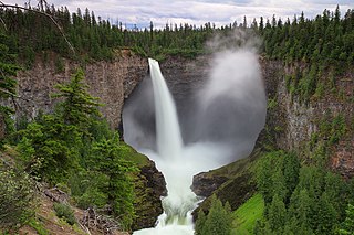
Helmcken Falls is a 141 m (463 ft) waterfall on the Murtle River within Wells Gray Provincial Park in British Columbia, Canada. The protection of Helmcken Falls was one of the reasons for the creation of Wells Gray Provincial Park in 1939.

Ebor Falls is a tiered waterfall on the Guy Fawkes River, located near Ebor and about 37 kilometres (23 mi) north-east of Wollomombi on Waterfall Way in the New England region of New South Wales, Australia.

Magod Falls is a group of waterfalls in Karnataka, India, where the river Bedti falls from a height of nearly 200 metres (660 ft) in two steps.

ʻŌpaekaʻa Falls is a waterfall located on the ʻŌpaekaʻa Stream in Wailua River State Park on the eastern side of the Hawaiian island of Kauai. It is a 151-foot (46 m) waterfall that flows over basalt from volcanic eruptions millions of years ago. Below the ridge down into the ravine through which the water falls can be seen the vertical dikes of basalt that cut through the horizontal Koloa lava flows. The name "ʻŌpaekaʻa" means rolling shrimp, "ʻopae" being Hawaiian for "shrimp," and "kaʻa" for "rolling". The name dates back to days when the native freshwater shrimp Atyoida bisulcata were plentiful in the stream and were seen rolling and tumbling down the falls and into the churning waters at the fall's base.

Mount Toby, 1,269 feet (387 m), is the highest summit of a sprawling collection of mostly wooded hills and knolls that rise from a distinct plateau-like upland in the towns of Sunderland and Leverett, Massachusetts, just east of the Connecticut River. This mountain mass, part of the Metacomet Ridge geology, is oval shaped and roughly three miles by two miles wide. Although three of the subordinate peaks have names of their own, none of them are noteworthy on their own, and the designation “Mount Toby” is most often used to describe the entire geologic mass. This article, therefore, describes the entire Mount Toby upland.
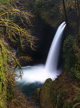
Metlako Falls is a waterfall on Eagle Creek in the Columbia River Gorge National Scenic Area in Hood River County, Oregon, United States. It is the furthest downstream of the major waterfalls on Eagle Creek. Like upstream Punch Bowl Falls, Metlako is also in the form of a punchbowl. The falls is 31 meters (101 ft) tall, though people have measured it anywhere from 30 to 46 m tall. It is the upstream limit for salmon spawning in Eagle Creek.

Canim Falls is a 25 metre high waterfall on the Canim River between Canim Lake and Mahood Lake in Wells Gray Provincial Park in the Cariboo region of the Central Interior of British Columbia, Canada. The waterfall has eroded steadily upstream and created a 4 km (2.5 mi) long canyon cut into a lava plateau associated with the Wells Gray-Clearwater volcanic field.
Mahood Falls is a waterfall in Wells Gray Provincial Park located on the Canim River between Canim Lake and Mahood Lake and northeast of 100 Mile House, British Columbia, Canada. The waterfall is 30 m (98 ft) high.

Dawson Falls is one of seven waterfalls on the Murtle River in Wells Gray Provincial Park, British Columbia, Canada.
Wy'east Falls is a waterfall on a small tributary of Eagle Creek in Hood River County, Oregon, U.S.

Phantom Falls or Coal Canyon Falls is a waterfall at Coal Canyon near Oroville, California, within the North Table Mountain Ecological Reserve. The waterfall is 166 feet (51 m) high and runs off the edge of Coal Canyon, in front of a grotto. A small pool at the bottom is home to a California newt subspecies, the Coastal Range newt. As a seasonal waterfall, Phantom Falls runs only during the rainy months, late autumn to early spring. It is named Phantom Falls because it disappears during the dry season.

Benham Falls are rapids of the Deschutes River located between the resort community of Sunriver and the town of Bend, Oregon, United States. With a pitch of 22.5°, they are rated Class 5 for watercraft, and are the largest falls on the upper Deschutes.

Dillon Falls are rapids on the Deschutes River in the U.S. state of Oregon near Bend in the Deschutes National Forest.

The Tamolitch Falls, now a seasonal waterfall, once had a constant flow on the McKenzie River in Lane County, Oregon. The site is located in the Willamette National Forest. In the 1960s, water was diverted for hydroelectric use from the stream above the falls; that section of the stream, as well as the falls, ceased to flow except during periods of heavy runoff or when water was diverted from the dams upstream. When this is not the case, the stream goes underground and now emerges below the falls. At the base of the former falls is the Tamolitch Blue Pool, a small body of water known for its blue color. Elevation: 2,487 feet

Hedge Creek Falls is a waterfall on Hedge Creek, in the Shasta Cascade area in Dunsmuir, California. There is a small cave located behind the waterfall, allowing visitors to walk behind the cascading water. Shortly after the waterfall, hedge creek flows into the Sacramento River south of Mossbrae Falls. There is a viewing platform over the river, with a view of Mount Shasta. Access to the waterfall and viewing platform is via a short hiking trail. The trail starts at a small park off the Dunsmuir Ave/Siskiyou Ave exit on Interstate 5. The waterfall is 0.2 miles (0.32 km) down Hedge Creek Falls Trail. The close proximity to Interstate 5, makes the waterfall a very popular stopping point for passing motorists.

Proxy Falls, also known as Lower Proxy Falls, is a cascade and plunge waterfall from a collection of springs on the shoulder of North Sister, that plunges into a gaping canyon near McKenzie Pass in the Willamette National Forest, near Belknap Springs, Oregon. The waterfall is notable for its main drop of 226 feet (69 m) which makes it one of the highest plunge waterfalls in Oregon.
Thunderbird falls is a waterfall located in Eklutna, Alaska. It has an elevation of about 100 feet and flows into the Eklutna River. Due to its proximity to Anchorage, about a thirty-minute drive, it is a popular place for tourists and those living nearby. The waterfall is comingled with a 1.6-mile round trip hike to attract people, especially those with young children and tourists, to the falls and the Chugach State Park, where it resides. The path has two main routes with the final destination being the only difference. The easier first route ends at a viewing deck near the top of the falls, whereas the second one is harder to traverse, but will end closer to the bottom of the falls.
