Yosemite Falls is the highest waterfall in Yosemite National Park, dropping a total of 2,425 feet (739 m) from the top of the upper fall to the base of the lower fall. Located in the Sierra Nevada of California, it is a major attraction in the park, especially in late spring when the water flow is at its peak.

Kings Canyon National Park is a national park of the United States in the southern Sierra Nevada, in Fresno and Tulare Counties, California. Originally established in 1890 as General Grant National Park, the park was greatly expanded and renamed on March 4, 1940. The park's namesake, Kings Canyon, is a rugged glacier-carved valley more than a mile (1,600 m) deep. Other natural features include multiple 14,000-foot (4,300 m) peaks, high mountain meadows, swift-flowing rivers, and some of the world's largest stands of giant sequoia trees. Kings Canyon is north of and contiguous with Sequoia National Park, and both parks are jointly administered by the National Park Service as the Sequoia and Kings Canyon National Parks.

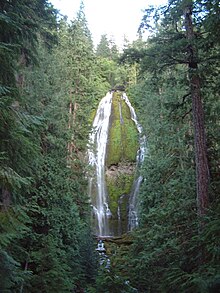
Multnomah Falls is a waterfall located on Multnomah Creek in the Columbia River Gorge, east of Troutdale, between Corbett and Dodson, Oregon, United States. The waterfall is accessible from the Historic Columbia River Highway and Interstate 84. Spanning two tiers on basalt cliffs, it is the tallest waterfall in the state of Oregon at 620 ft (189 m) in height. The Multnomah Creek Bridge, built in 1914, crosses below the falls, and is listed on the National Register of Historic Places.

The Mist Trail is one of the most popular short hikes in Yosemite National Park, California, USA. The steep hike follows the Merced River, starting at Happy Isles in Yosemite Valley, past Vernal Fall and Emerald Pool, to Nevada Fall.

Mount Adams, known by some Native American tribes as Pahto or Klickitat, is an active stratovolcano in the Cascade Range. Although Adams has not erupted in more than 1,000 years, it is not considered extinct. It is the second-highest mountain in Washington, after Mount Rainier.

Yellowstone Falls consist of two major waterfalls on the Yellowstone River, within Yellowstone National Park, Wyoming, United States. As the Yellowstone river flows north from Yellowstone Lake, it leaves the Hayden Valley and plunges first over Upper Falls of the Yellowstone River and then a quarter mile downstream over Lower Falls of the Yellowstone River, at which point it then enters the Grand Canyon of the Yellowstone, which is up to 1,000 feet deep.

Uvas Canyon County Park is a 1,147-acre (464 ha) natural park located in upper Uvas Canyon on the eastern side of the Santa Cruz Mountains, west of Morgan Hill, California. The park has several small waterfalls, some of which flow perennially, that feed into tributaries confluent with Uvas Creek. The park is part of the Santa Clara County Parks System, and facilitates picnics, hiking and overnight camping. It is one of the few parks in the area that allows dogs in the campgrounds.

Larch Mountain is an extinct volcano near Portland, Oregon. The name is misleading, as no western larch can be found there. It received that name when early lumbermen sold the noble fir wood as larch. The peak can be reached between May and November on paved Larch Mountain Road, 16 mi (26 km) east of Corbett, Oregon, although the road is closed during the winter and spring months. The road leading to Larch Mountain from the Historic Columbia River Highway is 14 miles long, which closed at milepost 10 from Nov. through late May or early June due to snow.

The Clearwater River is the largest tributary of the North Thompson River, joining it at the community of Clearwater, British Columbia. The Clearwater rises from glaciers in the Cariboo Mountains and flows in a mostly southerly direction for 201 km (125 mi) to the North Thompson. Its entire course, except the last 5 km (3 mi), is within Wells Gray Provincial Park. Its confluence with the North Thompson is protected by North Thompson River Provincial Park.

The Salmon River is a 33.5-mile (53.9 km) river in the Cascade Range in the U.S. state of Oregon that drains part of southwestern Mount Hood. The entire length of the river is a protected National Wild and Scenic River. Several portions are in protected wilderness. It is affluent to the Sandy River, a tributary of the Columbia River.

Wahclella Falls is a waterfall along Tanner Creek, a tributary of the Columbia River, Multnomah County, Oregon, United States. It enters the river within the Columbia River Gorge.

Spahats Creek Falls, also called Spahats Falls, is a waterfall on Spahats Creek within Wells Gray Provincial Park of British Columbia, Canada. Common references place the falls at around 60 m (197 ft) tall, but taking into account the second tier, it is closer to 75–80 meters tall. It is a popular stop for tourists and especially motorcoach tours since it is only 10 km (6.2 mi) off the busy Yellowhead Highway.

Salt Creek Falls is a cascade and plunge waterfall on Salt Creek, a tributary of the Middle Fork Willamette River, that plunges into a gaping canyon in the Willamette National Forest near Willamette Pass in Lane County, Oregon. The waterfall is notable for its main drop of 286 feet (87 m), ranking third highest among plunge waterfalls in Oregon, after Multnomah Falls and Watson Falls.) The pool at the bottom of Salt Creek Falls waterfall is 66 feet (20 m) deep.

The Robson River is a short but swift, rapid and waterfall-infested river in Mount Robson Provincial Park of British Columbia. It is a tributary of the Upper Fraser River and it originates near Robson Pass, which divides the Robson River and the headwaters of the Smoky River drainage. There are three lakes along the river's course as well as four waterfalls.

Uisge Ban Falls is a waterfall near Baddeck, Nova Scotia, Canada. The falls is located in Uisge Ban Falls Provincial Park near New Glen, Victoria County, 14.5 kilometres north of Baddeck.
Uisge Ban Falls Provincial Park is a provincial park near New Glen, in the Canadian province of Nova Scotia on Cape Breton Island. Located on the North Branch Road 14.5 kilometres (9.0 mi) north of Baddeck, the civic address of the park entrance is 715 North Branch Road, Baddeck Forks, Nova Scotia, Canada B0E 1B0.

The Mount Adams Recreation Area is a 21,000-acre (8,500 ha) recreation area in the U.S. state of Washington managed by the Yakama Nation Tribal Forestry Program. The area encompasses an ecologically complex and geologically active landscape. The region features the most rugged side of Mount Adams, including canyons and the Great Gap section of the Mount Adams circumnavigation route, a three-mile trail-less section over two great canyons and many difficult glacial creeks. At 12,276 feet (3,742 m), Mount Adams is one of the major Cascade mountains. The recreation area is on the east side of the mountain and is part of the Yakama Indian Reservation and includes the popular Bird Creek Meadows area.

North Falls is a waterfall located in the Silver Falls State Park at the east end of the city of Salem, in Marion County, in the U.S. state of Oregon. It is located in a privileged area on the west foothills where Mount Hood National Forest meets with the Middle Santiam Wilderness. Several prominent waterfalls are located in the Park along Trail of Ten Falls: South Falls, Drake Falls, Lower South Falls, and Winter Falls—among others.
Yocum Falls, is a waterfall located in the heart of the Mount Hood National Forest, in Clackamas County, in the U.S. state of Oregon. It is located in a privileged area in Zigzag canyon with several waterfalls including Little Zigzag Falls and Ramona Falls. The name, as well as Yocum Ridge, the south ridge of the Sandy Glacier on the west slope of Mount Hood, comes from businessman Oliver C. Yocum.

Diamond Creek Falls is a waterfall formed along Gibson Canyon on the north end of Willamette National Forest, east side of the city of Oakridge in Lane County, Oregon. Access to Diamond Creek Falls is located along Oregon Route 58 through trail paths that lead down to the stream and the base of the waterfall.