Related Research Articles
The Nass River is a river in northern British Columbia, Canada. It flows 380 km (240 mi) from the Coast Mountains southwest to Nass Bay, a sidewater of Portland Inlet, which connects to the North Pacific Ocean via the Dixon Entrance. Nass Bay joins Portland Inlet just south of Observatory Inlet.

The Nisga’a (Niska), often formerly spelled Nishga or Niska and spelled in the Nisga'a language as Nisg̱a’a, are an Indigenous people in British Columbia, Canada. They reside in the Nass River valley of northwestern British Columbia. The origin of the term Niska is uncertain. The spelling Nishga is used by the Nishga Tribal Council, and some scholars claim that the term means 'people of the Nass River'. The name is a reduced form of, which is a loan word from Tongass Tlingit, where it means 'people of the Nass River'.
The Laxsgiik is the name for the Eagle "clan" (phratry) in the language of the Tsimshian nation of British Columbia, Canada, and southeast Alaska. It is considered analogous or identical to identically named groups among the neighboring Gitksan and Nisga'a nations and also to lineages in the Haida nation.
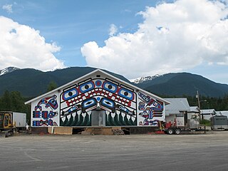
Gitlax̱t'aamiks, formerly New Aiyansh, is a Nisga'a village about 100 km (62 mi) north of Terrace, in the heart of the Nass River valley, Canada. It is one of four Nisga'a villages. Though it is located in British Columbia, it is also considered the "capital of the Nisga'a Nation". The Nisg̱a'a Lisims Government building, which opened in 2000, is located here. The area is home to 806 people and the Nisga'a Memorial Lava Bed Provincial Park. Gitlax̱t'aamiks is located overlooking a lava flow that erupted in the 18th century. The source for this lava flow was the Tseax Cone.
School District 92 Nisga'a is a school district in British Columbia, Canada. Situated in the Nass River valley it covers the First Nations area of the Nisga'a people north of Terrace. This includes the communities of Gitlaxt'aamiks, Gitwinksihlkw, Laxgalts'ap, Gingolx, and the surrounding settlements.

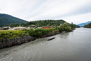
Lax̱g̱altsʼap is a Nisg̱a’a village of approximately 248, in the Nass River valley of British Columbia, Canada. It is one of the four main villages in the Nisg̱a’a Lisims, the formal name for their territory, and is situated on the north side of the Nass River between Gitwinksihlkw to the east and Ging̱olx to the west. It is approximately 24 km from where the Nass empties into the Pacific Ocean at Nass Bay. Road access is via the Nisga'a Highway.
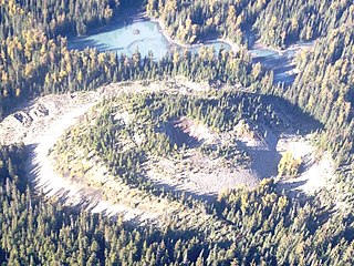
Tseax Cone is a small volcano in the Nass Ranges of the Hazelton Mountains in northwestern British Columbia, Canada. It has an elevation of 609 metres and lies within an east–west valley through which a tributary of the Tseax River flows. The volcano consists of two nested structures and was the source of four lava flows that descended into neighbouring valleys. A secondary eruptive centre lies just north of Tseax Cone on the opposite side of a lava-dammed lake. It probably formed simultaneously with Tseax Cone but the timing of volcanism at the two centres is not precisely known; they were both active sometime in the last 800 years. The area has been designated as a provincial park to protect these features.

Volcanic activity is a major part of the geology of Canada and is characterized by many types of volcanic landform, including lava flows, volcanic plateaus, lava domes, cinder cones, stratovolcanoes, shield volcanoes, submarine volcanoes, calderas, diatremes, and maars, along with less common volcanic forms such as tuyas and subglacial mounds.

Nisga'a Memorial Lava Bed Provincial Park is a provincial park in the Nass River valley in northwestern British Columbia, Canada, about 80 kilometres north of Terrace, and near the Nisga'a Villages of Gitlakdamix and Gitwinksihlkw.

The geology of the Pacific Northwest includes the composition, structure, physical properties and the processes that shape the Pacific Northwest region of North America. The region is part of the Ring of Fire: the subduction of the Pacific and Farallon Plates under the North American Plate is responsible for many of the area's scenic features as well as some of its hazards, such as volcanoes, earthquakes, and landslides.

Lava Lake is a lava dammed lake located in northwestern British Columbia, Canada. The lake lies within the Nisga'a Memorial Lava Beds Provincial Park, which includes fishing, hiking and other features.

The Silverthrone Caldera is a potentially active caldera complex in southwestern British Columbia, Canada, located over 350 kilometres (220 mi) northwest of the city of Vancouver and about 50 kilometres (31 mi) west of Mount Waddington in the Pacific Ranges of the Coast Mountains. The caldera is one of the largest of the few calderas in western Canada, measuring about 30 kilometres (19 mi) long (north-south) and 20 kilometres (12 mi) wide (east-west). Mount Silverthrone, an eroded lava dome on the caldera's northern flank that is 2,864 metres (9,396 ft) high, may be the highest volcano in Canada.
The Nass Ranges are a mountain range north of the Skeena River, west of Hazelton, and northeast of Terrace, British Columbia, Canada. It is a subrange of the Hazelton Mountains, which in turn form part of the Interior Mountains.

The Ksi Sii Aks is a tributary of the Nass River in northwestern British Columbia, Canada. It is most notable as the namesake of Tseax Cone, a volcano within its basin that was responsible for an eruption in the 17th century that killed 2,000 Nisgaʼa people. Prior to the eruption, the Nisgaʼa name for this river was Ksi Gimwitsʼax. Buried by the eruption, it eventually resurfaced. The Nisgaʼa recognized it as the same stream but renamed it Ksi Sii Aks: sii aks means "new body of water".

Gitwinksihlkw formerly Canyon City, is a Nisga'a Village in the Nass River valley of northwestern British Columbia, Canada, near that river's confluence with the Tseax River. An older spelling is Kitwilluchsilt. It is one of four Nisga'a villages. Road access is via the Nisga'a Highway.

The Volcano, also known as Lava Fork volcano, is a small cinder cone in the Boundary Ranges of the Coast Mountains in northwestern British Columbia, Canada. It is located approximately 60 km (40 mi) northwest of the small community of Stewart near the head of Lava Fork. With a summit elevation of 1,656 m (5,433 ft) and a topographic prominence of 311 m (1,020 ft), it rises above the surrounding rugged landscape on a remote mountain ridge that represents the northern flank of a glaciated U-shaped valley.

The volcanic history of the Northern Cordilleran Volcanic Province presents a record of volcanic activity in northwestern British Columbia, central Yukon and the U.S. state of easternmost Alaska. The volcanic activity lies in the northern part of the Western Cordillera of the Pacific Northwest region of North America. Extensional cracking of the North American Plate in this part of North America has existed for millions of years. Continuation of this continental rifting has fed scores of volcanoes throughout the Northern Cordilleran Volcanic Province over at least the past 20 million years and occasionally continued into geologically recent times.

The Nisga'a and Haida Crest Poles of the Royal Ontario Museum are a collection of four large totem poles, hand carved from western red cedar by the Nisga’a people and Haida people of British Columbia's coast. The poles are referred to as: Three Persons Along (Nisga'a); the Pole of Sag̱aw̓een (Nisga'a); the Shaking Pole of Kw’ax̱suu (Nisga'a); and House 16: Strong House Pole (Haida). Each of the crest poles tell a family story, as carved figures represent crests that commemorate family history by describing family origins, achievements and experiences. These memorial poles were typically placed in front of the owners' house along the beach.
Melita Lake, known to the Nisga'a as T’aam Baxhl Mihl, is a shallow lake in Nisga'a Memorial Lava Bed Provincial Park of northwestern British Columbia, Canada. Its primary inflow and outflow is Crater Creek, which flows west into the Tseax River. The elevation of Melita Lake varies from 550 to 551 m.
References
- 1 2 "Gitwinksihlkw". BC Geographical Names .
- 1 2 Williams-Jones, Glyn; Barendregt, René W.; Russell, James K; Le Moigne, Yannick; Enkin, Randolph J.; Gallo, Rose (2020). "The age of the Tseax volcanic eruption, British Columbia, Canada". Canadian Journal of Earth Sciences . 57 (10). NRC Research Press. Bibcode:2020CaJES..57.1238W. doi:10.1139/cjes-2019-0240. ISSN 1480-3313. S2CID 216209167.
| Archaeological sites | 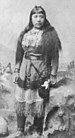 | |
|---|---|---|
| Ethnicities |
| |
| Languages | ||
| People |
| |
| Places | ||
| Towns and villages | ||
| Armed conflicts | ||
| Court cases and treaties | ||
| Modern issues | ||
| Miscellaneous | ||
| See also | ||
| | This article about a location on the Coast of British Columbia, Canada is a stub. You can help Wikipedia by expanding it. |
| | This First Nations in Canada-related article is a stub. You can help Wikipedia by expanding it. |
| | This article about disaster management or a disaster is a stub. You can help Wikipedia by expanding it. |