
The Nuu-chah-nulth, also formerly referred to as the Nootka, Nutka, Aht, Nuuchahnulth or Tahkaht, are one of the Indigenous peoples of the Pacific Northwest Coast in Canada. The term Nuu-chah-nulth is used to describe fifteen related tribes whose traditional home is on the west coast of Vancouver Island.

Bamfield is a community that is surrounded by Crown Land, First Nation Lands belonging to the Huu-ay-aht Nations, and portions of the Pacific Rim National Park, located on Barkley Sound, Vancouver Island in British Columbia. The community, with a population of 179 as of 2016, is divided by Bamfield Inlet.
Clayoquot is an anglicization of the Nuu-chah-nulth language name "Tla-o-qui-aht", one of the indigenous tribes of the region so named. It may refer to:

The Tla-o-qui-aht First Nations are a Nuu-chah-nulth First Nation in Canada. They live on ten reserves along the Pacific Rim National Park Reserve on Vancouver Island, British Columbia. The band is part of the Nuu-chah-nulth Tribal Council. There were 618 people living in the Tla-o-qui-aht reserves in 1995. Their primary economic activities are fishing and tourism.

Nootka Island is the largest island off the west coast of Vancouver Island in British Columbia, Canada. It is 510 square kilometres (200 sq mi) in area. It is separated from Vancouver Island by Nootka Sound and its side-inlets, and is located within Electoral Area A of the Strathcona Regional District.
Nuu-chah-nulth, a.k.a.Nootka, is a Wakashan language in the Pacific Northwest of North America on the west coast of Vancouver Island, from Barkley Sound to Quatsino Sound in British Columbia by the Nuu-chah-nulth peoples. Nuu-chah-nulth is a Southern Wakashan language related to Nitinaht and Makah.
The Mowachaht/Muchalaht First Nations are a First Nations government on the west coast of Vancouver Island in the Canadian province of British Columbia. The Mowachaht/Muchalaht First Nations are a member nation of the Nuu-chah-nulth Tribal Council, which spans all Nuu-chah-nulth-aht peoples except for the Pacheedaht First Nation.

Tseshaht First Nation is an amalgamation of many tribes up and down Alberni Inlet and in the Alberni Valley of central Vancouver Island in the Canadian province of British Columbia. They are a member of the Nuu-chah-nulth Tribal Council which includes all other Nuu-chah-nulth-aht peoples except the Pacheedaht First Nation.

The Yuułuʔiłʔatḥ Government or Ucluelet First Nation is the modern treaty government of the Yuułuʔiłʔatḥ in the Canadian province of British Columbia.
The Nuu-chah-nulth Tribal Council is a First Nations Tribal Council in the Canadian province of British Columbia, located on the west coast of Vancouver Island. The organization is based in Port Alberni, British Columbia.
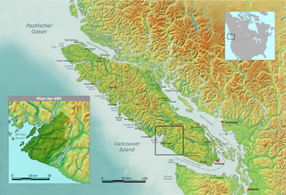
The Huu-ay-aht First Nations is a First Nations based on Pachena Bay about 300 km (190 mi) northwest of Victoria, British Columbia on the west coast of Vancouver Island, in Canada. The traditional territories of the Huu-ay-aht make up the watershed of the Sarita River. The Huu-ay-aht is a member of the Nuu-chah-nulth Tribal Council and is a member of the Maa-nulth Treaty Society. It completed and ratified its community constitution and ratified the Maa-nulth Treaty on 28 July 2007. The Legislative Assembly of British Columbia passed the Maa-nulth First Nations Final Agreement Act on Wednesday, 21 November 2007 and celebrated with the member-nations of the Maa-nulth Treaty Society that evening.

The Pacheedaht First Nation is a First Nations band government based on the west coast of Vancouver Island in British Columbia, Canada. Although the Pacheedaht people are Nuu-chah-nulth-aht by culture and language, they are not a member of the Nuu-chah-nulth Tribal Council and define themselves differently.
Meares Island is one of the many islands surrounding the Village of Tofino, British Columbia, Canada. Its name was given in 1862 by George Henry Richards, captain of HMS Hecate, in honor of John Meares. The island is located in the Clayoquot Sound region and is the location of Opitsat, the main village of the Tla-o-qui-aht First Nations, and was the location of Fort Defiance, a short-lived American fur-trading post founded by Captain Robert Gray.
Opitsaht, spelled also as Opitsat and Opitsitah, is a Tla-o-qui-aht settlement/community in the Southwest area of the Meares Islands, Clayoquot South, British Columbia. This peninsula-like region is the home to the Tla-o-qui-aht people from the Nuu-chah-nulth nation, a tribe from the Pacific Northwest region in the lower Vancouver area, known for their lifestyle revolving around the marine life trade and culture within the community.
Uu-a-thluk is the aquatic management organization of the Nuu-chah-nulth people on Vancouver Island, British Columbia.
The Maa-nulth First Nations, also known as First Nations of Maa-nulth Treaty Society, is a First Nations Treaty Society of Nuu-chah-nulth nations on the west coast of Vancouver Island.
Esowista Indian Reserve No. 3, also known as Esowista 3, is an Indian reserve located on the Esowista Peninsula in the Clayoquot Sound region of the west coast of Vancouver Island, British Columbia, Canada. Located at the head of Wickaninnish Bay, just east of Schooner Cove, it is part of the group of reserves under the governance of the Tla-o-qui-aht First Nations of the Nuu-chah-nulth peoples. Its population in 2006 was 160.
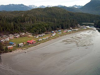
Pachena Bay is located 13 km (8.1 mi) south of Bamfield in Pacific Rim National Park at the southern end of Vancouver Island, British Columbia, Canada. It was the location of a First Nation's village that was destroyed by a tsunami in 1700.
The Sarita River is an approximately 25 km (16 mi)-long river on the west coast of Vancouver Island, British Columbia, Canada, just north of the hamlet of Bamfield.
