Clatsop County is one of the 36 counties in the U.S. state of Oregon. As of the 2020 census, the population was 41,072. The county seat is Astoria. The county is named for the Clatsop tribe of Native Americans, who lived along the coast of the Pacific Ocean prior to European settlement. Clatsop County comprises the Astoria, OR Micropolitan Statistical Area, or Sunset Empire, and is located in Northwest Oregon.
Scouting in the U.S. state of Oregon includes the Boy Scouts of America (BSA) and Girl Scouts (GSUSA) youth organizations, as well as newer organizations like the Baden-Powell Service Association and Vegan Scouts.

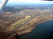
Warrenton is a small, coastal city in Clatsop County, Oregon, United States. Named for D.K. Warren, an early settler, the town is primarily a fishing and logging community. The population was 6,277 according to the 2020 US Census. Warrenton is a less urbanized area close to the Clatsop County seat, Astoria.

The Oregon Coast is a coastal region of the U.S. state of Oregon. It is bordered by the Pacific Ocean to its west and the Oregon Coast Range to the east, and stretches approximately 362 miles (583 km) from the California state border in the south to the Columbia River in the north. The region is not a specific geological, environmental, or political entity, and includes the Columbia River Estuary.
The Skipanon River is a tributary of the Columbia River, approximately 7 miles (11 km) long, on the Pacific coast of northwest Oregon in the United States. It is the last tributary of the Columbia on the Oregon side, draining an area of coastal bottom land bordered by sand dunes and entering the river from the south at its mouth west of Astoria.

The Lewis and Clark River is a tributary of Youngs River, approximately 20 miles (32 km) long, in northwest Oregon in the United States. It drains 62 square miles (160 km2) of the Northern Oregon Coast Range in the extreme northwest corner of the state, entering Youngs River just above its mouth on the Columbia River at Youngs Bay. Near the river's mouth is the site of former Fort Clatsop of the Lewis and Clark Expedition. The river is named for Meriwether Lewis and William Clark.

Fort Clatsop was the encampment of the Lewis and Clark Expedition in the Oregon Country near the mouth of the Columbia River during the winter of 1805–1806. Located along the Lewis and Clark River at the north end of the Clatsop Plains approximately 5 miles (8.0 km) southwest of Astoria, the fort was the last encampment of the Corps of Discovery, before embarking on their return trip east to St. Louis.

The Clatsop are a Chinookan-speaking Indigenous people of the Pacific Northwest of the United States. In the early 19th century they inhabited an area of the northwestern coast of present-day Oregon from the mouth of the Columbia River south to Tillamook Head, Oregon. Today, Clatsop descendants are members of the federally recognized Confederated Tribes of Siletz Indians, as well as the unrecognized Chinook Indian Nation and Clatsop-Nehalem Confederated Tribes.

The Necanicum River is a river on the Pacific coast of northwest Oregon in the United States, approximately 21 miles (34 km) long. It drains a timber-producing area of the Northern Oregon Coast Range northwest of Portland. It forms the first estuary south of the mouth of the Columbia River along the Oregon Coast, reaching the Pacific Ocean at Seaside in Clatsop County.

The John Day River is a tributary of the Columbia River, approximately 6 miles (10 km) long, in northwestern Oregon in the United States. The river rises in the Northern Oregon Coast Range in Clatsop County at 46.138889°N 123.704722°W.
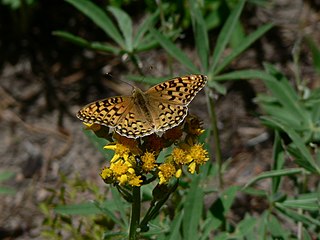
Speyeria zerene, the zerene fritillary, is a butterfly found in the western portions of the United States and Canada. The species was first described by William John Swainson in 1827.

Clatsop Spit is an unusually large sand spit on the Pacific coast along U.S. Route 101 between Astoria and the north end of Tillamook Head in Clatsop County, northwest Oregon, at the mouth of the Columbia River. The Clatsop Spit was formed by sediment brought to the coast by the Columbia River after the last ice age ended and the ocean level rose approximately 8,500 years ago. Here it was worked over and shaped by the wind and the waves until a vast and sandy plain was formed. In regular conversation, referring to Clatsop Spit usually refers to the northern end of the spit: the area that is bound by the Pacific to the west and the Columbia River to the northeast. In the past, the spit was known as Clatsop Sands.

The callippe silverspot butterfly is a federal endangered subspecies in the brush-footed butterfly family Nymphalidae. This is a subspecies. It is a member of the Heliconiinae, the subfamily known as longwings. The adult has a wingspan of just over two inches. The wings are eyecatching with a brown, tan, and black scalloped pattern on their surfaces and orange-brown with characteristic silver spots on the undersides. The wings and abdomen are hairy. The larvae are spiny, dark-colored caterpillars.

Myrtle's silverspot is a medium-sized butterfly in the brush foot family (Nymphalidae), an endangered subspecies of the zerene fritillary. It is endemic to California, where it is known from only about four locations just north of the San Francisco Bay Area, including two at Point Reyes National Seashore. Its wingspan is approximately 2.2 inches (56 mm). The upper surfaces of the wings are golden brown with numerous black spots and lines. The undersides are brown, orange and tan with black lines and silver and black spots. Larvae are dark colored with many sharp branching spines on their backs. Myrtle's silverspot is larger and paler than the closely related Behrens' silverspot, which is now limited to the vicinity of Point Arena in Mendocino County. Myrtle's silverspot is also closely related to the Oregon silverspot.
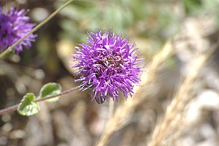
Monardella undulata is an uncommon species of flowering plant in the mint family known by the common name curlyleaf monardella. It is an annual herb and is endemic to the coast of California.
Clifton is an unincorporated community in Clatsop County, Oregon, United States. It is located north of U.S. Route 30, about nine miles northwest of Westport on the south bank of the Columbia River. It is on Clifton Channel across from Tenasillahe Island.
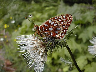
Speyeria zerene hippolyta, the Oregon silverspot, is a threatened butterfly that is found in the U.S. states of California and Oregon. It is a subspecies of Speyeria zerene.
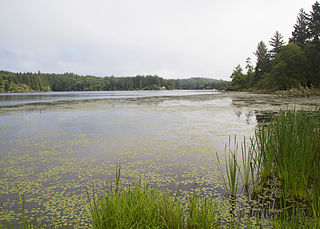
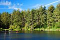
Cullaby Lake is a lake near Warrenton, Oregon, United States. It is the central feature of Cullaby Lake County Park, and one of the major lakes of Clatsop Plains.

Northwest Oregon is a geographic and cultural region of the U.S. state of Oregon, composed of Clatsop, Columbia, and Tillamook counties. The region encompasses the northernmost parts of the state along the lower Columbia River.