
A beach is a landform alongside a body of water which consists of loose particles. The particles composing a beach are typically made from rock, such as sand, gravel, shingle, pebbles, etc., or biological sources, such as mollusc shells or coralline algae. Sediments settle in different densities and structures, depending on the local wave action and weather, creating different textures, colors and gradients or layers of material.

Driftwood is wood that has been washed onto a shore or beach of a sea, lake, or river by the action of winds, tides or waves.
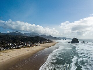
Cannon Beach is a city in Clatsop County, Oregon, United States. Its population was 1,690 at the 2010 census. It is a popular coastal Oregon tourist destination, famous for Haystack Rock, a 235 ft (72 m) sea stack that juts out along the coast. In 2013, National Geographic listed it as "one of the world's 100 most beautiful places."

Longshore drift from longshore current is a geological process that consists of the transportation of sediments along a coast parallel to the shoreline, which is dependent on the angle of incoming wave direction. Oblique incoming wind squeezes water along the coast, and so generates a water current which moves parallel to the coast. Longshore drift is simply the sediment moved by the longshore current. This current and sediment movement occur within the surf zone. The process is also known as littoral drift.

The Oregon Coast is a coastal region of the U.S. state of Oregon. It is bordered by the Pacific Ocean to its west and the Oregon Coast Range to the east, and stretches approximately 362 miles (583 km) from the California state border in the south to the Columbia River in the north. The region is not a specific geological, environmental, or political entity, and includes the Columbia River Estuary.

The Clatsop Plains are an area of wetlands and sand dunes between the Northern Oregon Coast Range and Pacific Ocean in northwestern Oregon in the United States. They stretch from near the mouth of the Columbia River south to the vicinity of Tillamook Head near Seaside. The plains are drained by several coastal rivers include the Skipanon River and the Necanicum River, which flow parallel to the coast and empty into the Columbia at Youngs Bay near Astoria and into the Pacific Ocean near Seaside respectively. At the time, the Lewis and Clark Expedition recorded a different river draining the plains which entered the Pacific near the current day Camp Rilea Armed Forces Training Center. Research, 200 years later in 2005, seems to have confirmed this by locating an old river channel.

The USS Shark was a schooner in the United States Navy from 1821 until it sank crossing the Columbia Bar in 1846.

Fort Stevens was an American military installation that guarded the mouth of the Columbia River in the state of Oregon. Built near the end of the American Civil War, it was named for Civil War general and former Washington Territory governor, Isaac I. Stevens. The fort was an active military reservation from 1863–1947. It is now listed on the National Register of Historic Places.

The Columbia Bar is a system of bars and shoals at the mouth of the Columbia River spanning the U.S. states of Oregon and Washington. It is one of the most dangerous bar crossings in the world, earning the nickname Graveyard of the Pacific. The bar is about 3 miles (5 km) wide and 6 miles (10 km) long.

Coastal geography is the study of the constantly changing region between the ocean and the land, incorporating both the physical geography and the human geography of the coast. It includes understanding coastal weathering processes, particularly wave action, sediment movement and weather, and the ways in which humans interact with the coast.

Peter Iredale was a four-masted steel barque that ran ashore October 25, 1906, on the Oregon coast en route to the Columbia River. She was abandoned on Clatsop Spit near Fort Stevens in Warrenton about four miles (6 km) south of the Columbia River channel. Wreckage is still visible, making it a popular tourist attraction as one of the most accessible shipwrecks of the Graveyard of the Pacific.

Ammophila breviligulata is a species of grass native to eastern North America, where it grows on sand dunes along the Atlantic Ocean and Great Lakes coasts. Beachgrass thrives under conditions of shifting sand, sand burial, and high winds; it is a dune-building grass that builds the first line of sand dunes along the coast. Beachgrass is less vigorous in stabilized sand, and is only infrequently found further inland than the coastal foredunes. On the Atlantic coastline of North America, Ammophila breviligulata has been observed as far south as North Carolina, and is often planted in dune restoration projects. Ammophila breviligulata was introduced to the Pacific coast of North America in the 1930s. It is proving to be invasive, and is increasingly important to coastal ecology and development in Oregon, Washington, and British Columbia.

Sand dune stabilization is a coastal management practice designed to prevent erosion of sand dunes. Sand dunes are common features of shoreline and desert environments. Dunes provide habitat for highly specialized plants and animals, including rare and endangered species. They can protect beaches from erosion and recruit sand to eroded beaches. Dunes are threatened by human activity, both intentional and unintentional. Countries such as the United States, Australia, Canada, New Zealand, the United Kingdom, and Netherlands, operate significant dune protection programs.
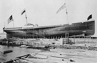
SS Great Republic was a sidewheel steamship and the largest passenger liner on the US west coast when it ran aground near the mouth of the Columbia River, on Sand Island, south of Ilwaco, Washington, in 1879, in a region of frequent wrecks known as the Graveyard of the Pacific.
The Clatsop are an ethnic group native to the US state of Oregon.

The SS Drexel Victory was a Victory-class cargo ship built during World War II. The SS Drexel Victory (MCV-712), was a type VC2-S-AP2 victory ship built by Permanente Metals Corporation, Yard 2, of Richmond, California under the Emergency Shipbuilding program. The Maritime Administration cargo ship was the 744th victory ship. Her keel was laid on February 25, 1945. The ship was christened on May 2, 1945. The ship was named in honor of Drexel University in Philadelphia, one of 150 educational institutions that had Victory ships named after them.
SS General Warren was an American steamship that operated on the Pacific Coast until she wrecked off the Oregon Coast in 1852.

Sand Island is an island in Baker Bay in the mouth of the Columbia River, located in Clatsop County, Oregon. It is situated north of Fort Stevens State Park and the Clatsop Spit, east of Cape Disappointment, and just south of Ilwaco, Washington. Sand Island is also the northernmost point in the state of Oregon.


