Cape Disappointment (Washington)

Last updated
Aerial view of Cape Disappointment, looking northeast USCG Cape Disappointment1.jpg
Aerial view of Cape Disappointment, looking northeast
South side of Cape Disappointment and the Cape Disappointment Lighthouse Cape Disappointment and Cape Disappointment Light.jpg
South side of Cape Disappointment and the Cape Disappointment Lighthouse

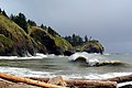
Cape Disappointment is a headland of the Pacific Northwest, located at the extreme southwestern corner of Washington, United States, on the north side of the Columbia River bar and just west of Baker Bay. The point of the cape is located on the Pacific Ocean in Washington's Pacific County, approximately two miles (3.2 km) southwest of the town of Ilwaco. [1] Cape Disappointment sees about 2,552 hours of fog a year—the equivalent of 106 days—making it one of the foggiest places in the U.S.[ citation needed ]

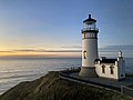
The cape was named on July 6, 1788, by British fur trader John Meares, who was sailing south from Nootka Island, Canada, in search of trade. He mistook the mouth of the Columbia River for a bay, which the ship could not enter due to a shallow shoal. Just missing the discovery of the river mentioned by Francisco Antonio Mourelle, he named them Cape Disappointment and Deception Bay. [2] George Vancouver credits John Meares in his account when he saw Cape Disappointment on April 27, 1792. [3]

Cape Disappointment State Park is located on the cape, as is the Cape Disappointment Lighthouse. United States Coast Guard Station Cape Disappointment is situated on the river near the state park. The station's crewmembers respond to 300–400 calls for assistance every year.

Related Research Articles

<span class="mw-page-title-main">George Vancouver</span> 18th-century English naval explorer

Captain George Vancouver was a British Royal Navy officer best known for his 1791–1795 expedition, which explored and charted North America's northwestern Pacific Coast regions, including the coasts of what are now the Canadian province of British Columbia as well as the US states of Alaska, Washington and Oregon. He also explored the Hawaiian Islands and the southwest coast of Australia.

<span class="mw-page-title-main">Strait of Juan de Fuca</span> Strait between Vancouver Island and the Olympic Peninsula

The Strait of Juan de Fuca is a body of water about 96 miles long that is the Salish Sea's main outlet to the Pacific Ocean. The international boundary between Canada and the United States runs down the centre of the Strait.

<span class="mw-page-title-main">Vancouver Island</span> Southwesternmost Island of Canada

Vancouver Island is an island in the northeastern Pacific Ocean and part of the Canadian province of British Columbia. The island is 456 km (283 mi) in length, 100 km (62 mi) in width at its widest point, and 32,100 km2 (12,400 sq mi) in total area, while 31,285 km2 (12,079 sq mi) are of land. The island is the largest by area and the most populous along the west coasts of the Americas.

<span class="mw-page-title-main">Oregon Coast</span> Coastal region of the U.S. state of Oregon

The Oregon Coast is a coastal region of the U.S. state of Oregon. It is bordered by the Pacific Ocean to its west and the Oregon Coast Range to the east, and stretches approximately 362 miles (583 km) from the California state border in the south to the Columbia River in the north. The region is not a specific geological, environmental, or political entity, and includes the Columbia River Estuary.

<span class="mw-page-title-main">Cape Lookout (Oregon)</span>

Cape Lookout is a sharp rocky promontory along the Pacific Ocean coast of northwestern Oregon in the United States. It is located in southwestern Tillamook County, approximately 10 miles (16 km) southwest of Tillamook, just south of Netarts Bay. The promontory extends 1.5 miles (2.4 km) perpendicular to the coast, and is approximately 0.5 miles (0.80 km) wide at its base, tapering as it extends outward from the coast. Cape Lookout State Park is located on the north side of the promontory, which is part of the Siuslaw National Forest. Cape Lookout Road travels past the base of the cape. Cape Lookout is a member of Tillamook's Three Capes Scenic Drive.

<span class="mw-page-title-main">John Meares</span> British navigator, explorer and fur trader (c. 1756 – 1809)

John Meares was an English navigator, explorer, and maritime fur trader, best known for his role in the Nootka Crisis, which brought Britain and Spain to the brink of war.

<span class="mw-page-title-main">Lewis and Clark National Historical Park</span> Historic site in Oregon and Washington, United States

The Lewis and Clark National Historical Park, located in the vicinity of the mouth of the Columbia River, commemorates the Lewis and Clark Expedition. Administration of the park, which includes both federal and state lands, is a cooperative effort of the National Park Service and the states of Oregon and Washington. The National Historical Park was dedicated on November 12, 2004.

<span class="mw-page-title-main">Robert Gray (sea captain)</span> American Merchant Sea Captain (1755–1806)

Robert Gray was an American Merchant Sea Captain who is known for his achievements in connection with two trading voyages to the northern Pacific coast of North America, between 1790 and 1793, which pioneered the American maritime fur trade in that region. In the course of those voyages, Gray explored portions of that coast and in the year 1790 he completed the first American circumnavigation of the world. He was also noted for coming upon and naming the Columbia River, in 1792, while on his second voyage.

<span class="mw-page-title-main">Columbia Bar</span>

The Columbia Bar, also frequently called the Graveyard of the Pacific, is a system of bars and shoals at the mouth of the Columbia River spanning the U.S. states of Oregon and Washington. It is known as one of the most dangerous bar crossings in the world. The bar is about 3 miles (5 km) wide and 6 miles (10 km) long.

<span class="mw-page-title-main">Cape Disappointment State Park</span> State park in Washington state, US

Cape Disappointment State Park is a public recreation area on Cape Disappointment, located southwest of Ilwaco, Washington, on the bottom end of Long Beach Peninsula, the northern headlands where the Columbia River meets the Pacific Ocean. The state park's 2,023 acres (819 ha) encompass a diverse landscape of old-growth forest, freshwater lakes, freshwater and saltwater marshes, and oceanside tidelands. Park sites include Fort Canby, the Lewis and Clark Interpretive Center, North Head Lighthouse, and Cape Disappointment Lighthouse. Cape Disappointment is one of several state parks and sites in Washington and Oregon that are included in Lewis and Clark National Historical Park.

<span class="mw-page-title-main">Long Beach Peninsula</span>

The Long Beach Peninsula is an arm of land on the southern coast of the state of Washington in the United States. Entirely within Pacific County, it is bounded on the west by the Pacific Ocean, the south by the Columbia River, and the east by Willapa Bay. Leadbetter Point State Park and Willapa National Wildlife Refuge are at the northern end of the peninsula and Cape Disappointment is at the southern end, with Pacific Pines State Park located in between.

<span class="mw-page-title-main">Cape Flattery</span> Headland in Washington state, United States

Cape Flattery is the northwesternmost point of the contiguous United States. It is in Clallam County, Washington on the Olympic Peninsula, where the Strait of Juan de Fuca joins the Pacific Ocean. It is also part of the Makah Reservation, and is the northern boundary of the Olympic Coast National Marine Sanctuary. Cape Flattery can be reached from a short hike, most of which is boardwalked. The westernmost point in the contiguous United States is at Cape Alava, south of Cape Flattery in Olympic National Park. However, the westernmost tip of Cape Flattery is almost exactly as far west as Cape Alava, the difference being approximately 5 seconds of longitude, about 360 feet (110 m), at high tide and somewhat more at low tide.

<span class="mw-page-title-main">Grays Harbor</span>

Grays Harbor is an estuarine bay located 45 miles (72 km) north of the mouth of the Columbia River, on the southwest Pacific coast of Washington state, in the United States of America. It is a ria, which formed at the end of the last ice age, when sea levels flooded the Chehalis River. The bay is 17 miles (27 km) long and 12 miles (19 km) wide. The Chehalis River flows into its eastern end, where the city of Aberdeen stands at that river's mouth, on its north bank, with the somewhat smaller city of Hoquiam immediately to its northwest, along the bayshore. Besides the Chehalis, many lesser rivers and streams flow into Grays Harbor, such as Hoquiam River and Humptulips River. A pair of low peninsulas separate it from the Pacific Ocean, except for an opening about two miles (3 km) in width. The northern peninsula, which is largely covered by the community of Ocean Shores, ends in Point Brown. Facing that across the bay-mouth is Point Chehalis, at the end of the southern peninsula upon which stands the town of Westport.

<span class="mw-page-title-main">North Head Light</span> Lighthouse

North Head Lighthouse is an active aid to navigation overlooking the Pacific Ocean from North Head, a rocky promontory located approximately two miles north of Cape Disappointment and the mouth of the Columbia River, near Ilwaco, Pacific County, in the U.S. state of Washington. It is part of Cape Disappointment State Park.

<span class="mw-page-title-main">Robert Gray's Columbia River expedition</span> Expedition conducted in 1792 in the Pacifif Northwest

In May 1792, American merchant sea captain Robert Gray sailed into the Columbia River, becoming the first recorded American to navigate into it. The voyage, conducted on the privately owned Columbia Rediviva, was eventually used as a basis for the United States' claim on the Pacific Northwest, although its relevance to the claim was disputed by the British. As a result of the outcome the river was afterwards named after the ship. Gray spent nine days on the river trading fur pelts before sailing out of the river.

<span class="mw-page-title-main">Charles William Barkley</span>

Charles William Barkley was a ship captain and maritime fur trader. He was born in Hertford, England, son of Charles Barkley.

<span class="mw-page-title-main">Nootka Crisis</span> Naval confrontation between the United States, Great Britain and Spain near Vancouver Island

The Nootka Crisis, also known as the Spanish Armament, was an international incident and political dispute between the Nuu-chah-nulth Nation, the Spanish Empire, the Kingdom of Great Britain, and the fledgling United States of America triggered by a series of events revolving around sovereignty claims and rights of navigation and trade. It took place during the summer of 1789 at the Spanish outpost Santa Cruz de Nuca, in Nootka Sound on Vancouver Island in present-day British Columbia, Canada. The commander of the outpost, Jose Esteban Martínez, seized some British commercial ships which had come for the maritime fur trade and to build a permanent post at Nootka Sound. Public outcry in Britain led to the mobilization of the Royal Navy, and the possibility of war. Both sides called upon allies, the Dutch joined the side of Britain; Spain mobilized their navy and her key ally France also mobilized theirs, but the latter soon announced they would not go to war. Without French help, Spain had little hope against the British and the Dutch, resulting in Spain seeking a diplomatic solution and making concessions.

<span class="mw-page-title-main">Columbia River Estuary</span> The estuary of the Columbia River

The Columbia River Estuary is situated on the Oregon–Washington border and the Pacific Coast of the United States. It was traditionally inhabited by the Chinook Native Americans and discovered by settlers in 1788. The Estuary plays host to a plethora of species of marine and terrestrial flora and fauna, and multiple conservation organisations exist that maintain the area. Geologically, it is situated on a continental margin of the North American Plate.

<span class="mw-page-title-main">Coast Guard Station Cape Disappointment</span> Coast Guard search and rescue station

United States Coast Guard Station Cape Disappointment, situated near Cape Disappointment, Washington, at the mouth of the Columbia River, is the largest United States Coast Guard search and rescue station on the Northwest Coast, with 50 crewmembers assigned. Cape Disappointment Station is also the site of the oldest search and rescue station within the Thirteenth Coast Guard District. The station's Area of Responsibility reaches from Ocean Park on the Washington Coast south to Tillamook Head on the Oregon Coast.

North West America was a British merchant ship that sailed on maritime fur trading ventures in the late 1780s. It was the first non-indigenous vessel built in the Pacific Northwest. In 1789 it was captured at Nootka Sound by Esteban José Martínez of Spain during the Nootka Crisis, after which it became part of the Spanish Navy and was renamed Santa Gertrudis la Magna and later Santa Saturnina.

References

  1. "Cape Disappointment". Geographic Names Information System . United States Geological Survey, United States Department of the Interior. September 10, 1979. Retrieved July 12, 2020.
  2. Meares, John (1790). Voyages made in the years 1788 and 1789 from China to the north west coast of America. London: Logographic Press. p.  167. OCLC   243542405 via the Internet Archive.
  3. Vancouver, George. Voyage of Discovery to the North Pacific Ocean, and Round the World in the Years 1791–95, volume 1, pp. 209–210. London, 1798.

Coordinates: 46°17′23″N124°03′38″W / 46.28972°N 124.06056°W / 46.28972; -124.06056