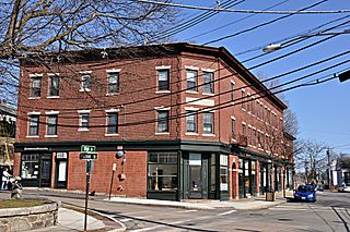
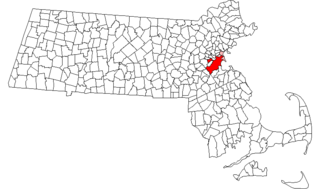
Newton Upper Falls is one of the thirteen villages within the city of Newton in Massachusetts, United States. The village is listed as the Newton Upper Falls Historic District on the National Register of Historic Places.

This is a list of the National Register of Historic Places listings in Suffolk County, Massachusetts.

Morton Street is a street in southern Boston, Massachusetts, United States. It extends from the southeastern end of the Arborway in Jamaica Plain to Washington Street in the Lower Mills Village of Dorchester. Most of the road is a connecting parkway, signed as part of Massachusetts Route 203, that provides access to Boston's Emerald Necklace of parks. That portion of the road was listed on the National Register of Historic Places in 2005.

The Stony Brook Reservation Parkways are a group of historic parkways in Boston and Dedham, Massachusetts. They provide access to and within the Stony Brook Reservation, a Massachusetts state park. The roadways and the park are administered by the Massachusetts Department of Conservation and Recreation, a successor to the Metropolitan District Commission, which oversaw their construction. The roads consist of the Dedham, Enneking, and Turtle Pond Parkways and West Boundary Road. Two roads within the park, Smithfield Road and Reservation Road, are listed as non-contributing properties. The park roads were built between 1894 and 1956, and were listed on the National Register of Historic Places in 2006.

The North Avenue Rural Historic District is a rural historic district in northern Mendon, Massachusetts. It covers 345 acres (140 ha), and extends predominantly along North Street, between Esty Road and Powers Road, and eastward along Hopedale Street and Trask Road. The area has been a rural agricultural area since the early days of Mendon's history in the 17th century. The present landscape retains boundaries and land-use patterns that were established in the 18th and 19th centuries, although some features have been lost or obscured to accommodate modern farming practices. The architecture of the area is predominantly 19th century; the oldest building in the district appears to be the Federal style house of the Seth Davenport Farm at 133 North Avenue, built c. 1780.
The Somersville Historic District encompasses the historic components of the mill village of Somersville in western Somers, Connecticut, United States. The district is centered on a mill complex on the Scantic River, which divides the district. The most significant years of development were between about 1835 and 1935, although the area has a history dating to the 1760s. The district was listed on the National Register of Historic Places in 1995. The Mill itself has since burned down and as of October 2018 is currently open field, although the canal structure remains in place.

Farnumsville Historic District is a historic district encompassing a historic mill village in Grafton, Massachusetts. It is located on the eastern bank of the Blackstone River, extending along Providence and Main Streets, roughly between Cross and Depot Streets, and radiating along those roads and adjacent streets. This area was one of Grafton's 19th century industrial mill villages, which was centered on the Farnum Mill, which first began operating in the second decade of the 19th century. The main mill building that survives dates to 1844, and the housing stock in the village is in a diversity of styles, built roughly between the 1820s and 1920s.
The Blackinton Historic District is a historic district in the western part of North Adams, Massachusetts, roughly along Massachusetts Avenue between Ashton and Doanes Avenues and Church Hill and the Boston & Maine Railroad. The district, which encompasses North Adams' best preserved mill village, was added to the National Register of Historic Places in 1985.

The South Lee Historic District encompasses the historic portion of the village of South Lee in Lee, Massachusetts. Extending mainly along Massachusetts Route 102 between Fairview Street and the Stockbridge town line, the village is a well-preserved 19th-century mill village, with fine Federal and Greek Revival buildings and a later 19th-century paper mill. It was listed on the National Register of Historic Places in 1999.

The Charlemont Village Historic District is a historic district on Massachusetts Route 2 between South Street and Harmony Lane, encompassing much of the village center of Charlemont, Massachusetts, United States. The district's properties represent the growth of the village center from its rural origin through a period of 19th century industrialization, including 18th and 19th century farmsteads, Greek Revival buildings of the mid 19th century, and later 19th century Victorian architectural styles. The district was added to the National Register of Historic Places in 1988.

The Machine Shop Village District is a historic district roughly bounded by Main, Pleasant, Clarendon, Water, 2nd Streets, and B&M Railroad in North Andover, Massachusetts. The district encompasses a well-preserved former textile mill village developed in the mid-19th century, with a variety of worker and upper-class housing, and two historic mill complexes. It was added to the National Register of Historic Places in 1982.

The Forge Village Historic District of Westford, Massachusetts, United States encompasses one of the town's historic 19th century mill villages. The focal point of the district is the mill complex of the Abbot Worsted Company, around which the village expanded after its founding in 1854. Prior to its founding the area was the site of a number of blacksmithies and iron forging operations, and was the site of a fulling mill in the 18th century. The center of the district is at the junction of East and West Prescott Streets with Pleasant Street, radiating away to ballfields on West Prescott, Abbot Street at Pleasant, and just beyond Orchard Street on East Prescott. Worker housing occupies a number of adjacent streets in the area.
Boston, Massachusetts is home to many listings on the National Register of Historic Places. This list encompasses those locations that are located south of the Massachusetts Turnpike. See National Register of Historic Places listings in northern Boston for listings north of the Turnpike. Properties and districts located elsewhere in Suffolk County's other three municipalities are also listed separately.

The Head of the River Historic District is a historic district encompassing a village area at the head of navigation of the Acushnet River, which separates Acushnet and New Bedford, Massachusetts. The village is centered at the junction of Tarkin Hill Road, River Road, and Mill Road in New Bedford, and Main Street in Acushnet. The area went through two significant periods of development: the first was in the late 18th and early 19th century, and the second was in the early 20th century. The district was listed on the National Register of Historic Places in 2009.
The Enfield Village Historic District encompasses the historic 19th century village center of Enfield, New Hampshire. The district was listed on the National Register of Historic Places in 2010. Multiple buildings of the district were added to the New Hampshire State Register of Historic Places in 2012.

The Exeter Waterfront Commercial Historic District encompasses the historic commercial and residential waterfront areas of Exeter, New Hampshire. The district extends along the north side of Water Street, roughly from Main Street to Front Street, and then along both sides of Water and High streets to the latter's junction with Portsmouth Street. It also includes properties on Chestnut Street on the north side of the Squamscott River. This area was where the early settlement of Exeter took place in 1638, and soon developed as a shipbuilding center. The district was listed on the National Register of Historic Places in 1980. It was enlarged in 1986 to include the mill complex of the Exeter Manufacturing Company on Chestnut Street.
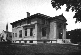
The Winchendon Village Historic District encompasses the 19th-century commercial center of Winchendon, Massachusetts. It extends along Front and School Streets from School Square to Spring Street, and continues north on Central Street as far as Summer Street. This area was developed primarily because of industrialization that took place along Miller's River beginning in the late 18th century and extending into the 1830s, and then expanded further with the arrival of the railroad in the area in the 1840s. This growth caused the area to eclipse the town's colonial town center. The area had risen to sufficient prominence by 1850 that the town hall was built there, which would be followed by other municipal buildings, including the 1913 Beals Memorial Library. The district was listed on the National Register of Historic Places in 1993.

Blackstone River Valley National Historical Park is a National Park Service unit in the states of Rhode Island and Massachusetts. The park was created for the purpose of preserving, protecting, and interpreting the industrial heritage of the Blackstone River Valley and the urban, rural, and agricultural landscape of that region. The Blackstone River Valley was the site of some of the earliest successful textile mills in the United States, and these mills contributed significantly to the earliest American Industrial Revolution. The subsequent construction of the Blackstone Canal, a few years after the successful completion of the Erie Canal, helped to sustain the region's industrial strength.

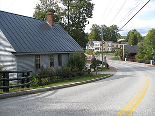
The Mill Village Historic District encompasses a small 19th-century industrial village on Stowe Street in Waterbury, Vermont. The area is a compact and somewhat isolated example of a mill village of the mid-19th century; it is roughly bounded by Stowe Street, Graves Brook, and the northbound offramp of Exit 10 from Interstate 89. It was listed on the National Register of Historic Places in 1979.

The Waitsfield Village Historic District encompasses much of the main village center of Waitsfield, Vermont. Extending along Vermont Route 100 on either side of Bridge Street, it is a well-preserved example of a 19th-century village, with only a few sympathetic 20th-century additions. It was listed on the National Register of Historic Places in 1983.


