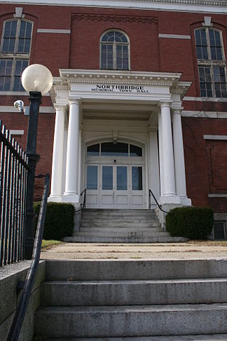
Northbridge is a town in Worcester County, Massachusetts, United States. The population was 16,335 at the 2020 census. The Northbridge Town Hall is located at 7 Main Street in Whitinsville. The town is now a part of the Blackstone River Valley National Heritage Corridor, of the National Park Service. Northbridge claims to history include: Native American Nipmuc lands, Colonel John Spring, who led the Uxbridge militia training company in the American Revolution, Samuel Spring, Revolutionary War Chaplain, the Residence of Ezra T. Benson 1830–1832, the birthplace of President Millard Fillmore's mother, Phoebe, and home to the Whitin Machine Works from 1831 to 1964.

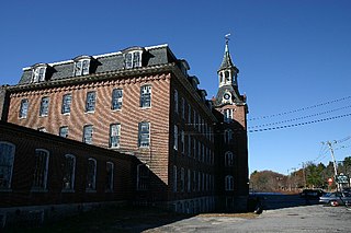
Whitinsville is an unincorporated village within the town of Northbridge in Worcester County, Massachusetts, United States. Whitinsville is a census-designated place (CDP) and its population was 6,750 at the 2020 census. Whitinsville is pronounced as if it were spelled "White-ins-ville". It was founded by the Whitin family, after whom it is also named. It is a post office jurisdiction, with a ZIP Code of 01588. It is located on the Mumford River, a tributary of the Blackstone River.
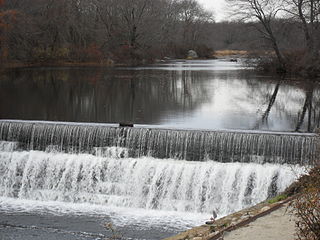
The Mumford River is an 18.3-mile-long (29.5 km) river in south-central Massachusetts. It is a tributary of the Blackstone River.
Robert Rogerson was an early American industrialist. He was born in Taunton, Massachusetts, and died in the United States.
Linwood is a village with its own post office in the towns of Northbridge and Uxbridge, Massachusetts, United States.
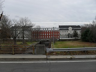
Paul Whitin was an American blacksmith and pioneering industrialist who in 1826 in Northbridge, Massachusetts established P Whitin and Sons, a new cotton mill with his sons. This company would grow and acquire other mills in the area. In 1831 his son John C Whitin obtained a patent for a mechanized Cotton Picker. Textile machinery would become a larger percentage of their business over time. would later become the largest maker of specialty textile machinery in the world.

North Uxbridge is a village and a post office in the town (township) of Uxbridge in Worcester County, Massachusetts, United States. The postal zip code is 01538. It is classified as a community or populated place located at latitude 42.088 and longitude -71.641 and the elevation is 266 feet (81 m). North Uxbridge appears on the Uxbridge U.S. Geological Survey Map. Worcester County is in the Eastern time zone and observes DST. North Uxbridge is located approximately 36 miles west-southwest of Boston, and 15 miles southeast of Worcester. The town meeting in 1885 set aside North Uxbridge as a "special district", since its population had exceeded 1000 people. North Uxbridge appeared as a separate Census tract in the 1960 census, with a population of 1882. In 2013, an Uxbridge DIY show, The Garage, with Steve Butler, went worldwide from Steve's garage in North Uxbridge.
Rogersons Village Historic District is a historic mill village in Uxbridge, Massachusetts, United States.
The Linwood Historic District is an industrial historic district in the Linwood village of Northbridge, Massachusetts. It is the site of the Linwood Cotton Mill and is roughly bounded by Linwood Avenue, Maple Court, and Pine Court. On June 16, 1989, it was added to the National Register of Historic Places.

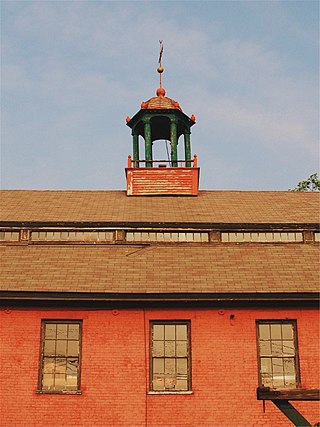
The Whitin Machine Works (WMW) was founded by Paul Whitin and his sons in 1831 on the banks of the Mumford River in Northbridge, Massachusetts. The village in this section of Northbridge became known as Whitinsville in 1835, in honor of its founder.

The Rockdale Common Housing District is a historic district at 4–20 McBride, 46–58 Plantation, and 37–42 Taft Sts. in Northbridge, Massachusetts, United States. The district is composed of a collection of tenement houses built from c. 1880 to 1920. They were built by members of the Whitin family, who owned most of the textile production capacity in Northbridge. The district was added to the National Register of Historic Places in 1983.

The US Post Office—Whitinsville Main is an historic post office building located at 58 Church Street in the village of Whitinsville in the town of Northbridge, Massachusetts. It is a single-story Colonial Revival masonry building, built of brick and cast stone and capped by a hip roof. It was built in 1938, and is distinguished for the massive pilasters that flank the central entrance, and for its cupola.
The Blackinton Historic District is a historic district in the western part of North Adams, Massachusetts, roughly along Massachusetts Avenue between Ashton and Doanes Avenues and Church Hill and the Boston & Maine Railroad. The district, which encompasses North Adams' best preserved mill village, was added to the National Register of Historic Places in 1985.

The Common District encompasses the main civic center of Wakefield, Massachusetts. It is centered on the historic town common, just south of Lake Quannapowitt, which was laid in 1644, when it became the heart of Old Reading. The area was separated from Reading as South Reading in 1818, and renamed Wakefield in 1868. The 25 acre district includes the buildings that line the common on Common Street and Main Street, which include the town hall, public library, YMCA, post office, and several churches. It was listed on the National Register of Historic Places in 1990.

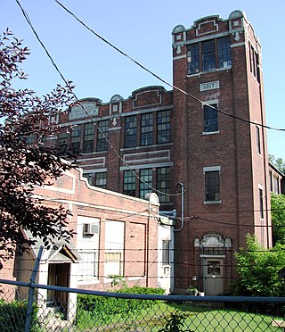
Northbridge High School is a public high school in Northbridge, Massachusetts. The school is operated by the Northbridge Public Schools.

Blackstone River Valley National Historical Park is a National Park Service unit in the states of Rhode Island and Massachusetts. The park was created for the purpose of preserving, protecting, and interpreting the industrial heritage of the Blackstone River Valley and the urban, rural, and agricultural landscape of that region. The Blackstone River Valley was the site of some of the earliest successful textile mills in the United States, and these mills contributed significantly to the earliest American Industrial Revolution. The subsequent construction of the Blackstone Canal, a few years after the successful completion of the Erie Canal, helped to sustain the region's industrial strength.

William R. Walker was an American architect from Providence, Rhode Island, who was later the senior partner of William R. Walker & Son.

The Manchaug Village Historic District is a historic district encompassing the 19th century industrial village center of Manchaug in Sutton, Massachusetts. Developed in the 1820s around textile mills on the Mumford River, it was the largest industrial area in Sutton, with at least three mill complexes in operation. The district is centered on the junction of Main Street with Manchaug, Putnam Hill, and Whitins Roads.
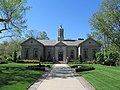
Sarah Elizabeth Whitin was sole benefactor of the Whitin Observatory, which she had built on the campus of Wellesley College near Boston.