West Boylston is a town in Worcester County, Massachusetts, United States and a northern suburb of Worcester. The population was 7,877 at the 2020 census. West Boylston includes the village of Oakdale, located on the opposite side of the Wachusett Reservoir from West Boylston center along Route 140. Although the town was split off from Boylston, it has a larger population than its eastern namesake.
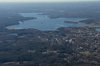
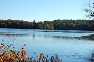
The Wachusett Reservoir is the second largest body of water in the state of Massachusetts. It is located in central Massachusetts, northeast of Worcester. It is part of the water supply system for metropolitan Boston maintained by the Massachusetts Water Resources Authority (MWRA). It has an aggregate capacity of 65 billion US gallons (250,000,000 m3) and an area of almost 7 square miles (18 km2). Water from the reservoir flows to the covered Norumbega Storage Facility via the Cosgrove Tunnel and the MetroWest Water Supply Tunnel. The reservoir has a maximum depth of 120 feet (37 m) and a mean depth of 48 feet (15 m).

The Wachusett Dam in Clinton, Massachusetts, impounds the Nashua River, creating the Wachusett Reservoir. Construction started in 1897 and was completed in 1905. It is part of the Nashua River Watershed.

The Ware River is a 35.4-mile-long (57.0 km) river in central Massachusetts. It has two forks, its West Branch, which begins in Hubbardston, Massachusetts, and its East Branch, which begins in Westminster, Massachusetts. The Ware River flows southwest through the middle of the state, joins the Quaboag River at Three Rivers, Massachusetts, to form the Chicopee River on its way to the Connecticut River.
The Quinapoxet River is part of the Nashua River watershed in northern Massachusetts in the United States. It is part of the Massachusetts Water Resources Authority water system supplying drinking water to the greater Boston area.

The Stillwater River is part of the Nashua River watershed. This river is part of the Massachusetts Water Resources Authority system that supplies drinking water to the greater Boston area.
This is a list of historic sites in Framingham, Massachusetts. There are several notable historic sites in Framingham, according to the Framingham Historical Society. This local society asserts:
While there are many historic spaces in Framingham, the Centre Common is the focal point for the town's past. Three of the town's most historic buildings on the Centre Common face "demolition by neglect." The Village Hall, the Edgell Memorial Library, and the Old Academy building not only house over 10,000 artifacts spanning four centuries of the town's history, but they are symbols of Framingham's commitment to educational excellence, civic engagement, and community pride.

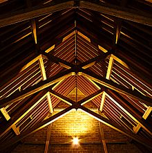
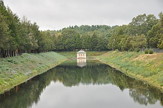
The Quinapoxet River Bridge is a historic bridge in West Boylston, Massachusetts, USA, carrying Thomas Street over the Quinapoxet River near its mouth at the Wachusett Reservoir. It is a concrete bridge faced in ashlar stone and was built in 1903 as part of the reservoir's construction. The bridge uses unusual construction methods designed to make it appear like an aqueduct, in a manner similar to the Ash Street Bridge in Weston, built at the time of the construction of the Weston Aqueduct.
The Oakdale Village Historic District is a historic district encompassing the small 19th-century village of Oakdale in West Boylston, Massachusetts. Located at the confluence of the Stillwater and Quinepoxet Rivers near their outlet into the Wachusett Reservoir, the village consists mainly of Greek Revival houses, although later Victorian styles are also present in smaller numbers. Its state of preservation is partly because development in the area was effectively halted when the process of building the reservoir began in the 1890s. A significant portion of the village was destroyed to make way for the reservoir, and railroads and industry were forced to relocate.
The Weston Aqueduct is an aqueduct operated by the Massachusetts Water Resources Authority (MWRA). Now part of the MWRA backup systems, it was designed to deliver water from the Sudbury Reservoir in Framingham to the Weston Reservoir in Weston. The 13.5-mile (21.7 km) aqueduct begins at the Sudbury Dam, and passes through the towns of Southborough, Framingham, Wayland, and Weston. In 1990, the route, buildings and bridges of the aqueduct were added to the National Register of Historic Places as the Weston Aqueduct Linear District.

The Sudbury Dam Historic District is a historic district on the southeastern end of Sudbury Reservoir off Massachusetts Route 30 in Framingham and Southborough, Massachusetts. The district encompasses the Sudbury Dam, which impounds the reservoir, and an area encompassing several historic structures located below the dam. The area includes water-supply-related structures from three phases of development of the Greater Boston water supply system. It was listed on the National Register of Historic Places in 1990.

Calvary Methodist Church is a historic Methodist church building at 300 Massachusetts Avenue in Arlington, Massachusetts. Built in 1919-23, the building is a near replica of Boston's Kings Chapel, executed in wood. Its tower is topped by a belfry designed by architect Charles Bulfinch in 1809 and built for use on Boylston Market; it was rescued from demolition and given to the church in 1921. The building was listed on the National Register of Historic Places in 1983.

The First Baptist Church is a historic church building at 457 Main Street in Stoneham, Massachusetts, United States, housing an evangelical congregation. The church was built in 1892 and added to the National Register of Historic Places in 1984. It is one central Stoneham's three 19th-century churches, and is a fine local example of Queen Anne architecture.

Reservoir Park is a historic park on Boylston Street in Brookline, Massachusetts. Its principal feature is Brookline Reservoir, formerly an element of the public water supply for neighboring Boston. The reservoir was built in 1848 as the main terminus of the now-defunct Cochituate Aqueduct, which delivered water from Lake Cochituate in the western suburbs. The reservoir covers 21.1 acres (8.5 ha), and is roughly kidney-shaped. A gravel path extends around the perimeter of the reservoir. The park is bounded on the north by Boylston Street, on the west by Lee Street, on the south by Dudley Street, and on the east by Warren and Walnut Streets.

The Old Union Meetinghouse, now the Union Baptist Church, is a historic church at 107 Mason Road in the Farmington Falls area of Farmington, Maine. Built in 1826–27, it is a high-quality and well-preserved example of a traditional late-colonial meetinghouse with Federal-style details. The building was listed on the National Register of Historic Places in 1973.

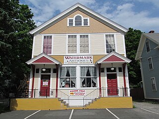
The Beaman Memorial Public Library is the public library of West Boylston, Massachusetts. It is located near the town common, at 8 Newton Street, in an architecturally distinguished Colonial Revival building constructed in 1912 to a design by Worcester architect Lucius Briggs. The building was listed on the National Register of Historic Places in 2016.
First Baptist Church Of Wetumpka is a Baptist church complex at 205 West Bridge Street in Wetumpka, Alabama. It is affiliated with the Southern Baptist Convention. It consisted of several connected buildings, centered on an original brick sanctuary building that was built from 1846 to 1852. The original sanctuary was slated for demolition by May 2020 following tornado damage. The grounds also include 1928–29 educational building, a 1959–60 second educational and office addition, a modern sanctuary built in 1967, and educational wing and fellowship hall that was completed in 1991. All of the buildings are centered on the original sanctuary and are linked together by a series of passages and corridors at the rear of the property. The original sanctuary was added to the Alabama Register of Landmarks and Heritage in 1977 and the National Register of Historic Places in 2008.

Mount Vernon Cemetery is a historic cemetery on Church Street in West Boylston, Massachusetts. It is actually composed of three separate cemeteries, which were eventually united under municipal ownership in the early decades of the 20th century. The oldest of them, the Beaman cemetery, dates to c. 1757 and is the town's oldest cemetery. It was forced to relocate to its present location next to the 1852 Mount Vernon Cemetery by the creation in 1904 of the Wachusett Reservoir; the association which owned the cemetery turned its resources over to the town ten years later. The Old Burying Ground was established c. 1790, and is the only originally municipal portion of the cemetery. The 1852 Mount Vernon Cemetery portion is the largest of the three, was designed in the rural cemetery style popular in the mid-19th century, and is where the cemetery's 1891 Holbrook Chapel is located.
Christ Episcopal Church, or simply Christ Church, is an historic church building located in Burlington, Iowa, United States. It is a part of the Episcopal Diocese of Iowa, and is a contributing property in the Heritage Hill Historic District listed on the National Register of Historic Places.
The Cheshire Town Hall Complex is a three-building set of municipal structures at the junction of Church and Depot Streets in Cheshire, Massachusetts. Built in 1898, the town hall is a prominent local example of Colonial Revival architecture, and the assemblage form an imposing civic statement in the village center. The buildings were listed on the National Register of Historic Places in 2017.