
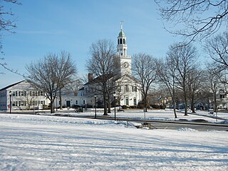
Haverhill is a city in Essex County, Massachusetts, United States. Haverhill is located 35 miles north of Boston on the New Hampshire border and about 17 miles from the Atlantic Ocean. The population was 67,787 at the 2020 United States census.

Methuen is a 23-square-mile city in Essex County, Massachusetts, United States. The population was 53,059 at the 2020 census. Methuen lies along the northwestern edge of Essex County, just east of Middlesex County and just south of Rockingham County, New Hampshire. The city is bordered by Haverhill to the northeast, North Andover to the southeast, Lawrence and Andover to the south, Dracut to the west, Pelham, New Hampshire to the northwest, and Salem, New Hampshire to the north. Methuen is located 17 miles (27 km) southwest from Newburyport, 30 miles (48 km) north-northwest of Boston and 25 miles (40 km) south-southeast of Manchester, New Hampshire.
Reading is a town in Middlesex County, Massachusetts, United States, 16 miles (26 km) north of central Boston. The population was 25,518 at the 2020 census.

Northern Essex Community College (NECC) is a public community college in Essex County, Massachusetts. The college serves residents of the Merrimack Valley and Southern New Hampshire. It has campuses in Haverhill and Lawrence. The college is part of the Massachusetts Higher Education system. More than 6,600 students are enrolled in 70 credit associate degree and certificate programs and another 3,400 take noncredit workforce development and community education classes on campus, and at businesses and community sites across the Merrimack Valley. The school's athletic teams are known as the Knights. Northern Essex Community College is accredited by the New England Commission of Higher Education.

Weir Hill Reservation is a 194-acre (0.79 km2) public park located in the town of North Andover, Massachusetts. The Trustees of Reservations owns and maintains the property.

The John H. Chafee Blackstone River Valley National Heritage Corridor is a National Heritage Corridor dedicated to the history of the early American Industrial Revolution, including mill towns stretching across 25 cities and towns near the river's course in Worcester County, Massachusetts, and Providence County, Rhode Island. It makes up a historical area in the Blackstone Valley and is named for the late US Senator from Rhode Island John Chafee. In 2014, the Blackstone River Valley National Historical Park was created out of a smaller portion of the National Heritage Corridor. The two units now exist as cooperative entities. The organization is headquartered at the building in Whitinsville, MA, which is located at 670 Linwood Ave, Whitinsville, MA 01588.

Long Wharf is a historic American pier in Boston, Massachusetts, built between 1710 and 1721. It once extended from State Street nearly a half-mile into Boston Harbor; today, the much-shortened wharf functions as a dock for passenger ferries and sightseeing boats.
Founded in Worcester, Massachusetts in 1987, the Greater Worcester Land Trust is a non-profit land conservation organization dedicated to the protection of important lands in Worcester and the surrounding towns. As a conservation land trust the trust's properties are managed simultaneously for wildlife habitat and passive recreation

The Swinton Estate is a large privately owned estate in North Yorkshire, England. It comprises some 20,000 acres (8,100 ha) of countryside in the Nidderdale Area of Outstanding Natural Beauty, extending 10 miles (16 km) west from the River Ure near Masham. The estate includes Swinton Park, the seat of the Danby family and of the Cunliffe-Lister family, an English country house in Swinton near Masham. It is set in 200 acres (81 ha) of parkland, lakes and gardens. The house is a Grade II* listed building, and now operates as the 42-bedroom Swinton Park Hotel.

Lake Saltonstall, referred to locally as Plug Pond, is a small lake located in the southwest park of the Winnekenni Park Conservation Area, near Winnekenni Castle, in Haverhill, Massachusetts.

The Wapack Wilderness is a 1,400-acre (6 km2) tract of forest in the towns of Rindge and New Ipswich, New Hampshire. The land is owned by the Hampshire Country School, a small, private school for students who do not thrive in traditional settings. It abuts Binney Pond Natural Area and land conserved by the New England Forestry Foundation. Watatic Mountain Wildlife Area is two miles (3 km) to the southeast, and Annett State Forest is two miles (3 km) to the northeast. The headwaters of the Millers River flow from the area, feeding into Converse Meadows and Lake Monomonac before entering Massachusetts.

Huntwicke, located in Topsfield, Massachusetts, is the former property of William A. Coolidge, a lawyer, financier, and art collector. Encompassing 571 acres (2.31 km2), it includes a 24-room Georgian-style mansion designed by architect Phillip Richardson in 1921 for John L. Saltonstall, other buildings, and landscaping by the firm of Frederick Law Olmsted. The brick mansion includes 14 bedrooms, six fireplaces, parquet floors, hand-carved wood paneling from the 1790 Nathaniel Saltonstall house in Haverhill, and extensive gardens. When Coolidge died in 1992, The Massachusetts Institute of Technology inherited the property. In 2000, MIT and the Essex County Greenbelt Association, a conservation organization and private, non-profit land trust, concluded an agreement to restrict further development, and the former estate, which includes over a mile of land along the Ipswich River, is now one of the largest conservation areas in private hands in Massachusetts.
Vine Brook is a brook in Middlesex County, United States. According to the History of Bedford, Vine Brook is "an important tributary of Shawsheen River." The book also states it as an excellent source of water-power in the 17th to 19th Centuries.

Ten Hills is a neighborhood in the northeastern part of the city of Somerville, Massachusetts. The area is roughly wedge-shaped, about 50 acres (200,000 m2) in size, and is bounded by the Mystic River to the north, McGrath Highway to the east, and is largely separated from the rest of Somerville by Interstate 93 to the southwest. Ten Hills is next to Assembly Square in the east, and Winter Hill in the southwest. The neighborhood landscape is predominated by a single hill, the peak of which is roughly at the intersection of Temple and Putnam Roads. The Ten Hills neighborhood is located in Ward 4, Precinct 1 of the City of Somerville, which is in the 34th district of Middlesex County.
Hale's Island is a 54-acre (22 ha) island located on the Merrimack River in Haverhill / Bradford, Massachusetts. The property is part of Silsby's farm.
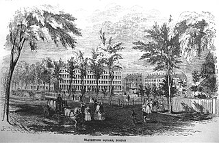
Blackstone and Franklin Squares are public parks located in the South End neighborhood of Boston, Massachusetts.
The Mill River is a 1.25-mile (2.01 km) long tributary of the Connecticut River in Springfield, Massachusetts. It flows from Watershops Pond to its confluence with the Connecticut River. It is referred to as "The Miracle Mile" in a 2009 master's thesis that outlines possibilities for reclaiming the river's mouth as a recreational area. As of 2011, the final 350 feet (110 m) of the river, including its mouth, is confined in a pipe underneath Interstate 91, railroad tracks and a car dealership. Many Springfield residents have bemoaned the loss of the Mill River as a recreational area, and hope to gain greater access to both it and Connecticut Rivers in upcoming years. As it has for over a century, today the Mill River serves as a barrier between Springfield neighborhoods. Surrounding it are some of the most densely urbanized locations in Springfield.

The Doyle Community Park & Center, located in the city of Leominster, Massachusetts, is a 170-acre (69 ha) landscaped urban park and open space reservation managed by The Trustees of Reservations, a non-profit conservation organization. It is also the location of the Doyle Center: a conservation education center, regional office, and green building initiative. The property consists of three main areas: Pierce Meadow, a landscaped urban park and former estate of Harry W. Pierce; the Doyle Center grounds, buildings, and adjoining woodlots; and a hay field and adjoining wetland.
Millennium Park is a 100 acre urban park in the West Roxbury neighborhood of Boston, Massachusetts.

