Cambridge and Concord Turnpike

Last updated
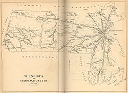
1919 map of the turnpikes in Massachusetts 19th century turnpikes Massachusetts.jpg
1919 map of the turnpikes in Massachusetts

The Cambridge and Concord Turnpike was an early turnpike between Cambridge and Concord, Massachusetts. Portions have been incorporated into today's Massachusetts Route 2; the remainder forms other major local roads.

Contents

Route description

The turnpike began at the western end of the West Boston Bridge in Cambridgeport (now Kendall Square). From there it proceeded along today's Broadway to Mechanics Square, [1] where it intersected with the Middlesex Turnpike (now Hampshire Street), then continued to the Cambridge Common, skirting Harvard College by 90 feet (27 m) as required by law, and from there proceeded northwest past Fresh Pond to Belmont Center, and then onwards to Lincoln by the route now known as Concord Avenue. ((Today's sharp turn after crossing Pleasant Street in Belmont Center was a revision to the original turnpike, as its original path directly up the hill ahead proved too difficult for transportation. The earlier route still exists as Centre Ave.) The turnpike continued through Lincoln in a direct line to Concord Center. Today one section forms part of Route 2 (from Route 128 to Bypass Road); the other continues into Concord as Cambridge Turnpike.

History

The Cambridge and Concord Turnpike Corporation was established on March 7-8, 1803, by act of the Massachusetts legislature. In 1805-06 most of the turnpike was constructed in very nearly a straight line from Cambridge to Concord Center, despite the needless difficulties this entailed with steep hills along the selected path. (After construction, the route was somewhat modified to improve its practicality.) Much of the road opened for business in February 1807, though the eastern segment within Cambridge was not completed until circa 1812.

Two tollgates were erected on the turnpike: one about 0.5 miles (0.80 km) west of Fresh Pond, and the other in Lincoln. No gates were erected within Cambridge, as a result of a lawsuit. The road's width varied from 50 feet (15 m) over much of its route to as much as 100 feet (30 m) at today's Broadway.

The turnpike was not an economic success, and in May 1829 it was converted to a public highway. Its poor profits were probably due to the uncompromising "straight line" route, which both impeded traffic by needless steep hills and bypassed the important town of Lexington.

Related Research Articles

<span class="mw-page-title-main">Cambridge, Massachusetts</span> City in Massachusetts, United States

Cambridge is a city in Middlesex County, Massachusetts, in the United States. It is a major suburb in the Greater Boston metropolitan area, located directly across the Charles River from Boston. The city's population as of the 2020 U.S. census was 118,403, making it the largest city in the county, the fourth most populous city in the state, behind Boston, Worcester, and Springfield, and ninth most populous city in New England. It was named in honor of the University of Cambridge in England, which was an important center of the Puritan theology that was embraced by the town's founders.

<span class="mw-page-title-main">Boston Post Road</span> Road in the northeast United States

The Boston Post Road was a system of mail-delivery routes between New York City and Boston, Massachusetts, that evolved into one of the first major highways in the United States.

<span class="mw-page-title-main">Lexington, Massachusetts</span> Town in Massachusetts, United States

Lexington is a suburban town in Middlesex County, Massachusetts, United States, located 10 miles (16 km) from Downtown Boston. The population was 34,454 as of the 2020 census. The area was originally inhabited by Native Americans, and was first settled by Europeans in 1641 as a farming community. Lexington is well known as the site of the first shots of the American Revolutionary War, in the Battle of Lexington on April 19, 1775, where the "Shot heard 'round the world" took place. It is home to Minute Man National Historical Park.

<span class="mw-page-title-main">Belmont, Massachusetts</span> Town in eastern Massachusetts

Belmont is a town in Middlesex County, Massachusetts, United States. It is a western suburb of Boston, Massachusetts, United States; and is part of the Greater Boston metropolitan area. At the 2020 U.S. census, its population was 27,295, up 10.4% from 2010.

<span class="mw-page-title-main">U.S. Route 3</span> Highway in the United States

U.S. Route 3 (US 3) is a United States Numbered Highway running 277.90 miles (447.24 km) from Cambridge, Massachusetts, through New Hampshire, to the Canada–US border near Third Connecticut Lake, where it connects to Quebec Route 257.

<span class="mw-page-title-main">Massachusetts Route 2</span> State highway in Massachusetts, United States

Route 2 is a 142.29-mile-long (228.99 km) major east–west state highway in Massachusetts, United States. Along with Route 9 and U.S. Route 20 to the south, these highways are the main alternatives to the Massachusetts Turnpike/I-90 toll highway. Route 2 runs the entire length of the northern tier of Massachusetts, beginning at the New York border, where it connects with New York State Route 2, and ending near Boston Common in Boston. Most of the route is an expressway through the northern tier of Massachusetts, with the longest surface road segments being the western portion. Older alignments of Route 2 are known as Route 2A.

<span class="mw-page-title-main">Fresh Pond (Cambridge, Massachusetts)</span> Reservoir in Cambridge, Massachusetts

Fresh Pond is a reservoir and park in Cambridge, Massachusetts. Prior to the Pond's use exclusively as a reservoir, its ice had been harvested by Boston's "Ice King", Frederic Tudor, and others, for shipment to North American cities and to tropical areas around the world. Fresh Pond is bordered by Fresh Pond Parkway, Huron Avenue, Grove Street, Blanchard Road, and Concord Avenue.

<span class="mw-page-title-main">Massachusetts Avenue (metropolitan Boston)</span> Major road in Greater Boston

Massachusetts Avenue is a major thoroughfare in Boston, Massachusetts, and several cities and towns northwest of Boston. According to Boston magazine, "Its 16 miles of blacktop run from gritty industrial zones to verdant suburbia, passing gentrified brownstones, college campuses and bustling commercial strips."

<span class="mw-page-title-main">Alewife Brook Reservation</span> State park and reservation in Massachusetts, USA

Alewife Brook Reservation is a Massachusetts state park and urban wild located in Cambridge, Arlington, and Somerville. The park is managed by the state Department of Conservation and Recreation and was established in 1900. It is named for Alewife Brook, which was also historically known as Menotomy River, a tributary of the Mystic River.

<span class="mw-page-title-main">Massachusetts Route 225</span> State highway in Massachusetts, US

Route 225 is a state highway in the U.S. state of Massachusetts. The highway runs 31.100 miles (50.051 km) from Route 2A in Lunenburg in northeastern Worcester County east to Route 2 in Lexington. Route 225 serves the western Middlesex County towns of Shirley, Groton, Westford, and Carlisle. The highway also passes through Bedford along its concurrency with Route 4, which terminates at the same junction with Route 2.

<span class="mw-page-title-main">Daniel Webster Highway</span>

Daniel Webster Highway is the name for several sections of U.S. Route 3 in New Hampshire. The highway is named after 19th century statesman Daniel Webster, a New Hampshire native.

<span class="mw-page-title-main">Middlesex Turnpike (Massachusetts)</span>

The Middlesex Turnpike was an early turnpike between Cambridge and Tyngsborough, Massachusetts and the New Hampshire border, where it connected with the Amherst Turnpike and thence Nashua and Claremont, New Hampshire.

<span class="mw-page-title-main">Fresh Pond Parkway</span>

Fresh Pond Parkway is a historic park and parkway on the western end of Cambridge, Massachusetts, part of the Metropolitan Park System of Greater Boston. The parkway was built in 1899 and added to the National Register of Historic Places in 2005.

Cambridge Highlands also known as "Area 12", is a neighborhood of Cambridge, Massachusetts bounded by the railroad tracks on the north and east, the Belmont town line on the west, and Fresh Pond on the south. In 2005 it had a population of 673 residents living in 281 households, and the average household income was $56,500.

<span class="mw-page-title-main">Battle Road</span> Historic road in Lincoln, Massachusetts

Battle Road, formerly known as the Old Concord Road and the Bay Road, is a historic road in Massachusetts, United States. It was formerly part of the main road connecting Lexington, Lincoln and Concord, three of the main towns involved in the American Revolutionary War. It was on Battle Road that thousands of colonial militia and British regulars fought during the redcoats' retreat from Concord to Boston on the morning and afternoon of April 19, 1775.

The Fifth Massachusetts Turnpike was one of over 60 toll roads in operation throughout Massachusetts in the first half of the 19th century. An act establishing the Corporation was approved by the Massachusetts legislature on March 1, 1799. The Preamble to the act reads:

<span class="mw-page-title-main">Paul Revere's Midnight Ride</span> Alert to the American colonial militia in 1775

The Midnight Ride was the alert to the American colonial militia in April 1775 to the approach of British forces before the battles of Lexington and Concord.

<span class="mw-page-title-main">Union Turnpike (Massachusetts)</span>

The Union Turnpike was one of over 60 toll roads in operation throughout Massachusetts in the first half of the 19th century. In the early part of 1803, a group of investors headed by Henry Bromfield (1727-1820) petitioned the Massachusetts State Legislature to form a corporation for the purpose of constructing a toll road from the center of Concord to Leominster.

Brooks Hill is a historic American Revolutionary War site associated with the revolution's first battle, the 1775 battles of Lexington and Concord. It was here, beside the Battle Road, that the British regulars passed on their marches to Concord from Boston, and again on their retreat east. It has also been referred to as Hardy's Hill.

References

  1. Hastings, Lewis. "The Streets of Cambridge - Some Accounts of Their Origin And History". The Cambridge Historical Society. Archived from the original on 11 June 2016. Retrieved 14 September 2013.

See also