Huntington, Massachusetts

Last updated

Huntington
Huntington Country Store, Huntington MA.jpg
Former Huntington Country Store
Seal of Huntington, Massachusetts.png
Hampshire County Massachusetts incorporated and unincorporated areas Huntington highlighted.svg
Location in Hampshire County in Massachusetts
Coordinates: 42°14′10″N72°52′35″W / 42.23611°N 72.87639°W / 42.23611; -72.87639
Country United States
State Massachusetts
County Hampshire
Settled1769
Incorporated (Norwich)1775
Incorporated (Huntington)March 5, 1855
Government
  Type Open town meeting
Area
  Total26.8 sq mi (69.4 km2)
  Land26.3 sq mi (68.2 km2)
  Water0.5 sq mi (1.2 km2)
Elevation
382 ft (116 m)
Population
 (2020)
  Total2,094
  Density78/sq mi (30/km2)
Time zone UTC-5 (Eastern)
  Summer (DST) UTC-4 (Eastern)
ZIP Code
01050
Area code 413
FIPS code 25-31785
GNIS feature ID0618203
Website www.huntingtonma.us

Huntington is a town in Hampshire County, Massachusetts, United States. The population was 2,094 at the 2020 census. [1] It is part of the Springfield, Massachusetts Metropolitan Statistical Area.

Contents

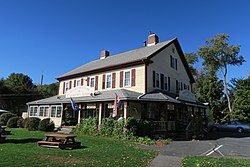
The main village of Huntington is in the south of the town, with the villages of Norwich [2] and Norwich Bridge in the center. (The villages are unofficial neighborhoods representing clusters of buildings in an otherwise rural town.)

The villages of Knightville (or Knightsville) and Indian Hollow toward the north were removed by the construction of the Knightville Dam from 1939 to 1941. [3]

History

Print of Huntington by L.R. Burleigh from 1886 with listing of sights Huntington, Mass. (2674477708).jpg
Print of Huntington by L.R. Burleigh from 1886 with listing of sights

What is now Huntington was first settled by Europeans in 1760, mostly migrants from Norwich, Connecticut who logged the land's valuable timber. [4] :9 Settlers were mainly subsistence farmers, who also raised animals, caught fish, tapped maple trees, and manufactured their own domestic goods. [4] :17–19 Most of what is now the towns of Huntington and Chester were sold at auction (along with other parcels) on June 2, 1762, as Plantation Number 9, to William Williams for £1,500. [4] :7 It was resold, and the three new proprietors allowed the 19 existing settlers to remain on the condition they build houses, clear land, and hire a Protestant minister. [5]

On June 29, 1773, the eastern portion of the town of Murrayfield (renamed Chester in 1783) was split off to form the district of Norwich, with most of the powers of a town. [4] :7 It shared a colonial representative with Chester until 1786, when it became a full town.

Early industry grew slowly. [4] :17–19 Just before 1800, Daniel and Richard Falley opened a tavern (which also functioned as a hotel) and store [6] :12 near the three-way boundary of Norwich, Blandford, and Chester, which was also the boundary between Hampshire and Hampden Counties. A post office opened nearby, on the Boston-Springfield-Albany stagecoach line; the neighborhood and the post office were named "Falleys' Cross road" or "Falley's X Roads". [5] [4] :13 In 1841, the Western Railroad (later part of the Boston and Albany Railroad) was constructed, drawing settlers and enabling profitable manufacturing to the vicinity of the stop, known as Chester Village to distinguish from the Chester Factories stop. [5] [4] :13 The post office and the neighborhood soon became known as Chester Village. [6] :12

Jurisdictional boundaries split streets and in some cases houses, causing problems with transportation of school children and law enforcement. [6] The nearby parts of Blandford and Chester were annexed to Norwich in 1853. [4] :8 In 1855, the Massachusetts General Court changed the name of the town to Huntington, in honor of Charles P. Huntington of Northampton, who had helped secure the annexation. [4] :8 Chester Village then became known as "the village" of Huntington. Charles Huntington donated $100 for the establishment of a library in his namesake town. [6] :12

In the Colonial Massachusetts tradition, Norwich initially functioned as both a secular town government and a church parish. Its town meetings were held at the town church ("meeting-hall") until 1841; a town hall was constructed in Knightville in 1842. [4] :12 Town meetings were held at a private Union Hall above a schoolhouse in Huntington village in the 1860s; the building burned in 1863 but was replaced [4] :12 and served as the town hall until 1954. [6] :12

Springfield Street Railway was extended to the town in 1905, and another trolley line operated to the town of Lee for a time. U.S. Route 20 was constructed through the town in 1920. [6] :22–23

The Huntington Textile Company supplied cloth to the U.S. military during the World Wars, but closed in 1952. [6] :16

Geography

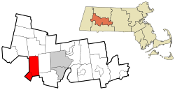
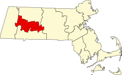
Huntington is in southwestern Hampshire County, bordered to the south and west by towns in Hampden County. The Westfield River runs through the town, joined by its West Branch at the village of Huntington in the southern part of the town. U.S. Route 20 follows the lower Westfield River and its West Branch through the town, leading southeast 12 miles (19 km) to the city of Westfield and northwest 23 miles (37 km) to Lee.

According to the United States Census Bureau, the town of Huntington has a total area of 26.8 square miles (69.4 km2), of which 26.3 square miles (68.2 km2) are land and 0.46 square miles (1.2 km2), or 1.78%, are water. [7]

Demographics

As of the census [18] of 2000, there were 2,174 people, 809 households, and 597 families residing in the town. The population density was 81.6 inhabitants per square mile (31.5/km2). There were 935 housing units at an average density of 35.1 per square mile (13.6/km2). The racial makeup of the town was 97.56% White, 0.41% African American, 0.18% Native American, 0.41% Asian, 0.28% from other races, and 1.15% from two or more races. Hispanic or Latino of any race were 1.84% of the population.

There were 809 households, out of which 35.0% had children under the age of 18 living with them, 60.4% were married couples living together, 8.9% had a female householder with no husband present, and 26.2% were non-families. 19.2% of all households were made up of individuals, and 6.8% had someone living alone who was 65 years of age or older. The average household size was 2.69 and the average family size was 3.10.

In the town, the population was spread out, with 27.7% under the age of 18, 6.4% from 18 to 24, 30.0% from 25 to 44, 26.1% from 45 to 64, and 9.7% who were 65 years of age or older. The median age was 37 years. For every 100 females, there were 98.5 males. For every 100 females age 18 and over, there were 98.2 males.

The median income for a household in the town was $18,958, and the median income for a family was $12,308. Males had a median income of $16,893 versus $17,414 for females. The per capita income for the town was $19,385. About 74.4% of families and 75.8% of the population were below the poverty line, including 36.2% of those under age 18 and 40.7% of those age 65 or over.

See also

Related Research Articles

<span class="mw-page-title-main">Hampden County, Massachusetts</span> County in Massachusetts, United States

Hampden County is a non-governmental county located in the Pioneer Valley of the U.S. state of Massachusetts, in the United States. As of the 2020 census, Hampden County's population was 465,825. Its traditional county seat is Springfield, the Connecticut River Valley's largest city, and economic and cultural capital; with an estimated population of 154,758, approximately 1 in 3 residents of Hampden County live in Springfield.

<span class="mw-page-title-main">Becket, Massachusetts</span> Town in Massachusetts, United States

Becket is a town in Berkshire County, Massachusetts, United States. It is part of the Pittsfield, Massachusetts Metropolitan Statistical Area. The population was 1,931 at the 2020 census.

<span class="mw-page-title-main">Monterey, Massachusetts</span> Town in Massachusetts, United States

Monterey is a small town in Berkshire County, Massachusetts, United States. It is part of the Pittsfield, Massachusetts Metropolitan Statistical Area. The population was 1,095 at the 2020 census.

<span class="mw-page-title-main">New Marlborough, Massachusetts</span> Town in Massachusetts, United States

New Marlborough is a town in Berkshire County, Massachusetts, United States. It is part of the Pittsfield, Massachusetts Metropolitan Statistical Area. The population was 1,528 at the 2020 census. New Marlborough consists of five villages: Clayton, Hartsville, Mill River, New Marlborough Village and Southfield.

<span class="mw-page-title-main">Otis, Massachusetts</span> Town in Massachusetts, United States

Otis is a town in Berkshire County, Massachusetts, United States. It is part of the Pittsfield, Massachusetts, Metropolitan Statistical Area. The population was 1,634 at the 2020 census.

<span class="mw-page-title-main">Peru, Massachusetts</span> Town in Massachusetts, United States

Peru is a town in Berkshire County, Massachusetts, United States. The population was 814 at the 2020 census.

<span class="mw-page-title-main">Sandisfield, Massachusetts</span> Town in Massachusetts, United States

Sandisfield is a town in Berkshire County, Massachusetts, United States. It is part of the Pittsfield, Massachusetts Metropolitan Statistical Area. The population was 989 at the 2020 census.

<span class="mw-page-title-main">Washington, Massachusetts</span> Town in Massachusetts, United States

Washington is a town in Berkshire County, Massachusetts, United States. It is part of the Pittsfield, Massachusetts, Metropolitan Statistical Area. The population was 494 at the 2020 census.

<span class="mw-page-title-main">Windsor, Massachusetts</span> Town in Massachusetts, United States

Windsor is a town in Berkshire County, Massachusetts, United States. It is part of the Pittsfield, Massachusetts Metropolitan Statistical Area. The population was 831 at the 2020 census.

<span class="mw-page-title-main">Whately, Massachusetts</span> Town in Massachusetts, United States

Whately is a town in Franklin County, Massachusetts, United States. The population was 1,607 at the 2020 census. It is part of the Springfield, Massachusetts Metropolitan Statistical Area.

<span class="mw-page-title-main">Chester, Massachusetts</span> Town in Massachusetts, United States

Chester is a town in Hampden County, Massachusetts, United States, situated in Western Massachusetts. It is part of the Springfield metropolitan statistical area. The town includes the Chester Factory Village Historic District. The total population was 1,228 in the 2020 census.

<span class="mw-page-title-main">Montgomery, Massachusetts</span> Town in Massachusetts, United States

Montgomery is a town in Hampden County, Massachusetts, United States. The population was 819 at the 2020 census. It is part of the Springfield, Massachusetts Metropolitan Statistical Area.

<span class="mw-page-title-main">Russell, Massachusetts</span> Town in Massachusetts, United States

Russell is a town in Hampden County, Massachusetts, United States. The population was 1,643 at the 2020 census. It is part of the Springfield, Massachusetts Metropolitan Statistical Area.

<span class="mw-page-title-main">Southwick, Massachusetts</span> Town in Massachusetts, United States

Southwick is a town in Hampden County, Massachusetts, United States. The population was 9,232 at the 2020 census, down from 9,502 at the 2010 census. It is part of the Springfield, Massachusetts Metropolitan Statistical Area.

<span class="mw-page-title-main">Cummington, Massachusetts</span> Town in Massachusetts, United States

Cummington is a town in Hampshire County, Massachusetts, United States. The population was 829 at the 2020 census, a decline from the figure of 872 tabulated in 2010. It is part of the Springfield, Massachusetts Metropolitan Statistical Area.

<span class="mw-page-title-main">Plainfield, Massachusetts</span> Town in Massachusetts, United States

Plainfield is a town on the northwestern edge of Hampshire County, Massachusetts, United States, about 25 miles east of Pittsfield and 30 miles northwest of Northampton. The population was 633 at the 2020 census. It is part of the Springfield, Massachusetts Metropolitan Statistical Area.

<span class="mw-page-title-main">Westhampton, Massachusetts</span> Town in Massachusetts, United States

Westhampton is a town in Hampshire County, Massachusetts, United States. The population was 1,622 at the 2020 census. It is part of the Springfield, Massachusetts Metropolitan Statistical Area.

<span class="mw-page-title-main">Williamsburg, Massachusetts</span> Town in Massachusetts, United States

Williamsburg is a town in Hampshire County, Massachusetts, United States. The population was 2,504 at the 2020 census. It is part of the Springfield, Massachusetts Metropolitan Statistical Area.

<span class="mw-page-title-main">Worthington, Massachusetts</span> Town in Massachusetts, United States

Worthington is a town in Hampshire County, Massachusetts, United States. The population was 1,193 at the 2020 census, up from 1,156 at the 2010 census. It is part of the Springfield, Massachusetts Metropolitan Statistical Area.

<span class="mw-page-title-main">Huntington (CDP), Massachusetts</span> Census-designated place in Massachusetts, United States

Huntington is a census-designated place (CDP) comprising the main village in the town of Huntington in Hampshire County, Massachusetts, United States. The population of the CDP was 936 at the 2010 census, out of a total town population of 2,180. It is part of the Springfield, Massachusetts Metropolitan Statistical Area.

References

  1. "Census - Geography Profile: Huntington town, Hampshire County, Massachusetts". United States Census Bureau . Retrieved November 14, 2021.
  2. Images show ‘forgotten valley’ life before Knightville Dam
  3. 1 2 3 4 5 6 7 8 9 10 11 Rev. J. H. Bisbee (December 1876). "History of Huntington".
  4. 1 2 3 General Committee (June 22, 1941). "Souvenir Program from Dedication of Robert Packer Cross Memorial Bridge".
  5. 1 2 3 4 5 6 7 Mrs. Edward W. Caron (July 1955). "Historical Review". Town of Huntington (Centennial Celebration Program).
  6. "Geographic Identifiers: 2010 Census Summary File 1 (G001): Huntington town, Hampshire County, Massachusetts". American Factfinder. U.S. Census Bureau. Archived from the original on February 13, 2020. Retrieved August 8, 2017.
  7. "TOTAL POPULATION (P1), 2010 Census Summary File 1, All County Subdivisions within Massachusetts". United States Census Bureau. Archived from the original on February 12, 2020. Retrieved September 13, 2011.
  8. "Massachusetts by Place and County Subdivision – GCT-T1. Population Estimates". United States Census Bureau. Archived from the original on November 3, 2011. Retrieved July 12, 2011.
  9. "1990 Census of Population, General Population Characteristics: Massachusetts" (PDF). US Census Bureau. December 1990. Table 76: General Characteristics of Persons, Households, and Families: 1990. 1990 CP-1-23. Archived from the original (PDF) on December 7, 2013. Retrieved July 12, 2011.
  10. "1980 Census of the Population, Number of Inhabitants: Massachusetts" (PDF). US Census Bureau. December 1981. Table 4. Populations of County Subdivisions: 1960 to 1980. PC80-1-A23. Retrieved July 12, 2011.
  11. "1950 Census of Population" (PDF). 1: Number of Inhabitants. Bureau of the Census. 1952. Section 6, Pages 21-10 and 21-11, Massachusetts Table 6. Population of Counties by Minor Civil Divisions: 1930 to 1950. Retrieved July 12, 2011.{{cite journal}}: Cite journal requires |journal= (help)
  12. "1920 Census of Population" (PDF). Bureau of the Census. Number of Inhabitants, by Counties and Minor Civil Divisions. Pages 21-5 through 21-7. Massachusetts Table 2. Population of Counties by Minor Civil Divisions: 1920, 1910, and 1920. Retrieved July 12, 2011.
  13. "1890 Census of the Population" (PDF). Department of the Interior, Census Office. Pages 179 through 182. Massachusetts Table 5. Population of States and Territories by Minor Civil Divisions: 1880 and 1890. Retrieved July 12, 2011.
  14. "1870 Census of the Population" (PDF). Department of the Interior, Census Office. 1872. Pages 217 through 220. Table IX. Population of Minor Civil Divisions, &c. Massachusetts. Retrieved July 12, 2011.
  15. "1860 Census" (PDF). Department of the Interior, Census Office. 1864. Pages 220 through 226. State of Massachusetts Table No. 3. Populations of Cities, Towns, &c. Retrieved July 12, 2011.
  16. "City and Town Population Totals: 2020−2022". United States Census Bureau . Retrieved November 24, 2023.
  17. "U.S. Census website". United States Census Bureau . Retrieved January 31, 2008.