Worthington, Massachusetts

Last updated

Worthington, Massachusetts
Corners Grocery, Worthington MA.jpg
Corners Grocery
Seal of Worthington, Massachusetts.png
Hampshire County Massachusetts incorporated and unincorporated areas Worthington highlighted.svg
Location in Hampshire County in Massachusetts
Coordinates: 42°23′50″N72°56′10″W / 42.39722°N 72.93611°W / 42.39722; -72.93611
Country United States
State Massachusetts
County Hampshire
Settled1764
Incorporated1768
Government
  Type Open town meeting
Area
  Total32.1 sq mi (83.1 km2)
  Land31.9 sq mi (82.7 km2)
  Water0.2 sq mi (0.4 km2)
Elevation
1,433 ft (437 m)
Population
 (2020)
  Total1,193
  Density37/sq mi (14/km2)
Time zone UTC-5 (Eastern)
  Summer (DST) UTC-4 (Eastern)
ZIP Code
01098
Area code 413
FIPS code 25-82175
GNIS feature ID0618212
Website www.worthington-ma.us

Worthington is a town in Hampshire County, Massachusetts, United States. The population was 1,193 at the 2020 census, [1] up from 1,156 at the 2010 census. It is part of the Springfield, Massachusetts Metropolitan Statistical Area.

Contents

Worthington is discussed by name in the Aaron Lewis song "Massachusetts" and referenced by the population size in "Country Boy". Both songs are on the album Town Line , released in 2011.

History

Worthington was first settled in 1764 and was officially incorporated in 1768. The town's officials had settled for new land after the settling of Northampton in 1654. In the 1760s, the wilderness that became Worthington was largely unpopulated. The 1840s and 1850s saw the arrival of a new form of transportation: railways. An effort to bring a line through Worthington failed. Although a train station was built in Huntington, many Worthington families began selling their farms and moving to western New York State, Ohio and further west in search of cheap land . By the 1860s, Worthington's population had declined to 925. These were years marked by deep conflict and rapid technological change.

The population continued to decline—818 in 1875, 763 in 1885, 569 in 1910—yet in these same decades, many present-day town institutions were established. In 1887, the second Congregational Church burned down. The third and current church, including a steeple, bells, organ, and new stained glass windows, was built on the same site and dedicated in 1888. While the permanent population of farmers and small manufacturers declined steadily, Worthington gradually gained a reputation as a summer resort. A casino on Buffington Hill Road, a hotel, several boarding houses, and many summer homes brought many visitors as well as income to the town. The maple sugaring industry expanded into a commercial enterprise during this period. Worthington's population sagged during the 1930s and 40s, reaching its low point of 363 in 1945. With fewer people, Worthington's one-room schools closed, post offices were consolidated, and The Grange was forced to merge with its neighbors. During the winter of 1931, the Lafayette Inn burned to the ground and was never rebuilt.

During the 1950s and 1960s, the town began to grow again, a reflection of improved roads. In August 1949, a special town meeting appropriated $6,800 to build a new fire house, which was completed the following year. The Palettes and Trowels Club met for the first time in 1950 and became a haven for several Worthington artists. The town's bicentennial celebration in 1968 was held from June 29 to July 6; events included a parade, an antique fair, an exhibit of photographs, a tour of Worthington homes, a play entitled "Bicentennial Quilting Party", and a beard-growing contest. The late 1960s and early 1970s saw more population growth. During the 1980s, the Hilltown Artisans Guild was established. [2]

Geography

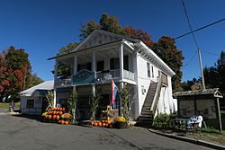
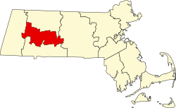
Worthington is in western Hampshire County, bordering the Berkshires. It is bordered by Cummington to the north, Chesterfield to the east, Huntington to the southeast, Chester in Hampden County to the south, Middlefield to the southwest, and Peru in Berkshire County to the west. Worthington Center and Worthington Corners are two neighboring villages near the center of the town, while Ringville and South Worthington are in the southeast and West Worthington is in the northwest.

Massachusetts Route 112 crosses the town, leading north to Cummington and south to Huntington. Massachusetts Route 143 follows Route 112 briefly northeast from Worthington Corners but leads east to Chesterfield and Williamsburg, and west to Peru and Hinsdale.

According to the United States Census Bureau, Worthington has a total area of 32.1 square miles (83.1 km2), of which 31.9 square miles (82.7 km2) are land and 0.2 square miles (0.4 km2), or 0.46%, are water. [3] The town is within the Westfield River watershed, with the Middle Branch of the Westfield River flowing through the western side of the town.

Climate

Climate data for Worthington, Massachusetts, 1991–2020 normals: 1285ft (392m)
MonthJanFebMarAprMayJunJulAugSepOctNovDecYear
Record high °F (°C)65
(18)
73
(23)
81
(27)
89
(32)
91
(33)
93
(34)
94
(34)
93
(34)
91
(33)
84
(29)
76
(24)
69
(21)
94
(34)
Mean maximum °F (°C)53.5
(11.9)
55.1
(12.8)
63.9
(17.7)
78.2
(25.7)
84.8
(29.3)
87.8
(31.0)
88.9
(31.6)
87.6
(30.9)
84.9
(29.4)
76.2
(24.6)
66.6
(19.2)
56.5
(13.6)
90.3
(32.4)
Mean daily maximum °F (°C)31.5
(−0.3)
34.6
(1.4)
42.5
(5.8)
55.4
(13.0)
66.7
(19.3)
74.7
(23.7)
79.6
(26.4)
78.1
(25.6)
71.4
(21.9)
59.1
(15.1)
47.0
(8.3)
36.4
(2.4)
56.4
(13.6)
Daily mean °F (°C)21.7
(−5.7)
23.6
(−4.7)
31.6
(−0.2)
43.5
(6.4)
54.6
(12.6)
63.1
(17.3)
67.9
(19.9)
66.3
(19.1)
59.2
(15.1)
47.6
(8.7)
37.1
(2.8)
27.6
(−2.4)
45.3
(7.4)
Mean daily minimum °F (°C)11.9
(−11.2)
12.7
(−10.7)
20.6
(−6.3)
31.6
(−0.2)
42.5
(5.8)
51.5
(10.8)
56.3
(13.5)
54.5
(12.5)
47.0
(8.3)
36.2
(2.3)
27.2
(−2.7)
18.8
(−7.3)
34.2
(1.2)
Mean minimum °F (°C)−7.6
(−22.0)
−5.2
(−20.7)
2.0
(−16.7)
20.2
(−6.6)
28.8
(−1.8)
37.7
(3.2)
46.6
(8.1)
43.7
(6.5)
33.3
(0.7)
23.3
(−4.8)
12.0
(−11.1)
2.7
(−16.3)
−9.1
(−22.8)
Record low °F (°C)−16
(−27)
−19
(−28)
−13
(−25)
8
(−13)
22
(−6)
32
(0)
41
(5)
38
(3)
25
(−4)
16
(−9)
−4
(−20)
−9
(−23)
−19
(−28)
Average precipitation inches (mm)3.95
(100)
3.56
(90)
4.25
(108)
4.29
(109)
4.20
(107)
5.12
(130)
4.57
(116)
4.46
(113)
4.78
(121)
5.59
(142)
4.10
(104)
5.22
(133)
54.09
(1,373)
Average snowfall inches (cm)19.30
(49.0)
18.20
(46.2)
13.80
(35.1)
4.00
(10.2)
0.10
(0.25)
0.00
(0.00)
0.00
(0.00)
0.00
(0.00)
0.00
(0.00)
0.40
(1.0)
4.60
(11.7)
16.70
(42.4)
77.1
(195.85)
Source 1: NOAA [4]
Source 2: XMACIS (temp records & monthly max/mins) [5]

Demographics

At the 2000 census, [17] there were 1,270 people, 503 households and 363 families living in the town. The population density was 39.6 inhabitants per square mile (15.3/km2). There were 582 housing units at an average density of 18.2 per square mile (7.0/km2). The racial makeup of the town was 98.27% White, 0.31% African American, 0.08% Native American, 0.24% Asian, and 1.10% from two or more races. Hispanic or Latino of any race were 1.02% of the population.

There were 503 households, of which 31.8% had children under the age of 18 living with them, 60.8% were married couples living together, 7.6% had a female householder with no husband present, and 27.8% were non-families. 21.3% of all households were made up of individuals, and 8.0% had someone living alone who was 65 years of age or older. The average household size was 2.52 and the average family size was 2.96.

24.5% of the population were under the age of 18, 6.3% from 18 to 24, 26.8% from 25 to 44, 31.4% from 45 to 64, and 11.0% who were 65 years of age or older. The median age was 42 years. For every 100 females, there were 98.1 males. For every 100 females age 18 and over, there were 92.6 males.

The median household income was $53,047 and the median family income was $60,132. Males had a median income of $42,500 compared with $26,438 for females. The per capita income for the town was $24,190. About 1.5% of families and 3.5% of the population were below the poverty line, including 2.0% of those under age 18 and 1.4% of those age 65 or over.

Worthington is discussed by name in the Aaron Lewis song "Massachusetts" and referenced by the population size in "Country Boy". Both songs are on the album Town Line , released in 2011. [18] [ better source needed ]

So I just pass the sign that welcomes me to Worthington
Established long before this country came to be
A place that hasn't really changed with time
The way this country that I love, it used to be

Aaron Lewis, "Massachusetts"

The song references the fact that the town of Worthington pre-existed the United States, being settled some twelve years before the end of the Revolutionary War.

Composer Rolande Maxwell Young wrote the "Worthington Bicentennial March" in honor of the town's bicentennial in the 1960s.

Maple syrup and sugar houses

Worthington is home to many agricultural endeavors, including the manufacturing of maple syrup, with three sugar houses open nearly year-round. [19]

Notable people


See also

Related Research Articles

<span class="mw-page-title-main">Berkshire County, Massachusetts</span> County in Massachusetts, United States

Berkshire County is the westernmost county in the U.S. state of Massachusetts. As of the 2020 census, the population was 129,026. Its largest city and traditional county seat is Pittsfield. The county was founded in 1761. The Berkshire Hills are centered on Berkshire County. Residents are known as Berkshirites. It exists today only as a historical geographic region, and has no county government, with the exception of the retirement board for former county workers, and certain offices such as the sheriff and registry of deeds.

<span class="mw-page-title-main">Hampshire County, Massachusetts</span> County in Massachusetts, United States

Hampshire County is a historical and judicial county located in the U.S. state of Massachusetts. As of the 2020 census, the population was 162,308. Its most populous municipality is Amherst, its largest town in terms of landmass is Belchertown, and its traditional county seat is Northampton. The county is named after the county Hampshire, in England. Hampshire County is part of the Springfield, MA Metropolitan Statistical Area. Together with Hampden County, Hampshire County municipalities belong to the Pioneer Valley Planning Commission.

<span class="mw-page-title-main">Peru, Massachusetts</span> Town in Massachusetts, United States

Peru is a town in Berkshire County, Massachusetts, United States. The population was 814 at the 2020 census.

<span class="mw-page-title-main">Savoy, Massachusetts</span> Town in Massachusetts, United States

Savoy is a town in Berkshire County, Massachusetts, United States. It is part of the Pittsfield, Massachusetts Metropolitan Statistical Area. The population was 645 at the 2020 census.

<span class="mw-page-title-main">Washington, Massachusetts</span> Town in Massachusetts, United States

Washington is a town in Berkshire County, Massachusetts, United States. It is part of the Pittsfield, Massachusetts, Metropolitan Statistical Area. The population was 494 at the 2020 census.

<span class="mw-page-title-main">Windsor, Massachusetts</span> Town in Massachusetts, United States

Windsor is a town in Berkshire County, Massachusetts, United States. It is part of the Pittsfield, Massachusetts Metropolitan Statistical Area. The population was 831 at the 2020 census.

<span class="mw-page-title-main">Merrimac, Massachusetts</span> Town in Massachusetts, United States

Merrimac is a small town in Essex County, Massachusetts, United States, and on the southeastern border of New Hampshire, approximately 34 miles (55 km) northeast of Boston and 10 miles (16 km) west of the Atlantic Ocean. It was incorporated on April 11, 1876. It is situated along the north bank of the Merrimack River in the Merrimack Valley. The population was 6,723 at the 2020 census. Historically a mill town, it has long since become a largely residential community. It is part of the Greater Boston metropolitan area.

<span class="mw-page-title-main">Ashfield, Massachusetts</span> Town in Massachusetts, United States

Ashfield is a town in Franklin County, Massachusetts, United States. The population was 1,695 at the 2020 census. It is part of the Springfield, Massachusetts Metropolitan Statistical Area.

<span class="mw-page-title-main">Warwick, Massachusetts</span> Town in Massachusetts, United States

Warwick is a town in Franklin County, Massachusetts, United States. The population was 780 at the 2020 census. It is part of the Springfield, Massachusetts Metropolitan Statistical Area.

<span class="mw-page-title-main">Whately, Massachusetts</span> Town in Massachusetts, United States

Whately is a town in Franklin County, Massachusetts, United States. The population was 1,607 at the 2020 census. It is part of the Springfield, Massachusetts Metropolitan Statistical Area.

<span class="mw-page-title-main">Brimfield, Massachusetts</span> Town in Massachusetts, United States

Brimfield is a town in Hampden County, Massachusetts, United States. The population was 3,694 at the 2020 census. It is part of the Springfield, Massachusetts Metropolitan Statistical Area.

<span class="mw-page-title-main">Cummington, Massachusetts</span> Town in Massachusetts, United States

Cummington is a town in Hampshire County, Massachusetts, United States. The population was 829 at the 2020 census, down from 872 at the 2010 census. It is part of the Springfield, Massachusetts Metropolitan Statistical Area.

<span class="mw-page-title-main">Huntington, Massachusetts</span> Town in Massachusetts, United States

Huntington is a town in Hampshire County, Massachusetts, United States. The population was 2,094 at the 2020 census. It is part of the Springfield, Massachusetts Metropolitan Statistical Area.

<span class="mw-page-title-main">Plainfield, Massachusetts</span> Town in Massachusetts, United States

Plainfield is a town on the northwestern edge of Hampshire County, Massachusetts, United States, about 25 miles east of Pittsfield and 30 miles northwest of Northampton. The population was 633 at the 2020 census. It is part of the Springfield, Massachusetts Metropolitan Statistical Area.

<span class="mw-page-title-main">Westhampton, Massachusetts</span> Town in Massachusetts, United States

Westhampton is a town in Hampshire County, Massachusetts, United States. The population was 1,622 at the 2020 census. It is part of the Springfield, Massachusetts Metropolitan Statistical Area.

<span class="mw-page-title-main">Williamsburg, Massachusetts</span> Town in Massachusetts, United States

Williamsburg is a town in Hampshire County, Massachusetts, United States. The population was 2,504 at the 2020 census. It is part of the Springfield, Massachusetts Metropolitan Statistical Area.

<span class="mw-page-title-main">Sherborn, Massachusetts</span> Town in Massachusetts, United States

Sherborn is a town in Middlesex County, Massachusetts, United States. Located in Boston's MetroWest region, is in area code 508 and has the ZIP code 01770. As of the 2020 U.S. Census, the town population was 4,401.

<span class="mw-page-title-main">Berlin, Massachusetts</span> Town in Massachusetts, United States

Berlin is a town in Worcester County, Massachusetts, United States. The town was first settled in 1665 and incorporated in 1812, and is governed under the open town meeting system. It is located 12 miles (19 km) northeast of Worcester and 29 miles (47 km) west of Boston. The population was 3,158 at the 2020 census.

<span class="mw-page-title-main">Holden, Massachusetts</span> Town in Massachusetts, United States

Holden is a town in Worcester County, Massachusetts, United States. The town was founded in 1741, and the Town Square was donated by John Hancock, former Governor of Massachusetts. The population was 19,905 at the 2020 census.

<span class="mw-page-title-main">Townsend, Massachusetts</span> Town in Massachusetts, United States

Townsend is a town in Middlesex County, Massachusetts, United States. The population was 9,127 at the 2020 census.

References

  1. "Census - Geography Profile: Worthington town, Hampshire County, Massachusetts". United States Census Bureau . Retrieved November 14, 2021.
  2. "History of the Town of Worthington". Worthington Historical Society. November 8, 2012. Retrieved January 6, 2019.
  3. "Geographic Identifiers: 2010 Census Summary File 1 (G001): Worthington town, Hampshire County, Massachusetts". American Factfinder. U.S. Census Bureau. Archived from the original on February 13, 2020. Retrieved August 9, 2017.
  4. "Worthington, Massachusetts 1991-2020 Monthly Normals" . Retrieved December 13, 2023.
  5. "xmACIS". National Oceanic and Atmospheric Administration. Retrieved December 13, 2023.
  6. "Total Population (P1), 2010 Census Summary File 1". American FactFinder, All County Subdivisions within Massachusetts. United States Census Bureau. 2010.
  7. "Massachusetts by Place and County Subdivision - GCT-T1. Population Estimates". United States Census Bureau. Retrieved July 12, 2011.
  8. "1990 Census of Population, General Population Characteristics: Massachusetts" (PDF). US Census Bureau. December 1990. Table 76: General Characteristics of Persons, Households, and Families: 1990. 1990 CP-1-23. Retrieved July 12, 2011.
  9. "1980 Census of the Population, Number of Inhabitants: Massachusetts" (PDF). US Census Bureau. December 1981. Table 4. Populations of County Subdivisions: 1960 to 1980. PC80-1-A23. Retrieved July 12, 2011.
  10. "1950 Census of Population" (PDF). Bureau of the Census. 1952. Section 6, Pages 21-10 and 21-11, Massachusetts Table 6. Population of Counties by Minor Civil Divisions: 1930 to 1950. Retrieved July 12, 2011.
  11. "1920 Census of Population" (PDF). Bureau of the Census. Number of Inhabitants, by Counties and Minor Civil Divisions. Pages 21-5 through 21-7. Massachusetts Table 2. Population of Counties by Minor Civil Divisions: 1920, 1910, and 1920. Retrieved July 12, 2011.
  12. "1890 Census of the Population" (PDF). Department of the Interior, Census Office. Pages 179 through 182. Massachusetts Table 5. Population of States and Territories by Minor Civil Divisions: 1880 and 1890. Retrieved July 12, 2011.
  13. "1870 Census of the Population" (PDF). Department of the Interior, Census Office. 1872. Pages 217 through 220. Table IX. Population of Minor Civil Divisions, &c. Massachusetts. Retrieved July 12, 2011.
  14. "1860 Census" (PDF). Department of the Interior, Census Office. 1864. Pages 220 through 226. State of Massachusetts Table No. 3. Populations of Cities, Towns, &c. Retrieved July 12, 2011.
  15. "1850 Census" (PDF). Department of the Interior, Census Office. 1854. Pages 338 through 393. Populations of Cities, Towns, &c. Retrieved July 12, 2011.
  16. "City and Town Population Totals: 2020-2022". United States Census Bureau . Retrieved November 10, 2023.
  17. "U.S. Census website". United States Census Bureau . Retrieved January 31, 2008.
  18. "aaron lewis massachusetts - Google Search". www.google.com. Retrieved January 6, 2019.
  19. February 18, Posted; February 18, 2018 at 06:30 AM | Updated; PM, 2018 at 06:38 (February 18, 2018). "Massachusetts sugar shacks 2018 season: Here are maple producers with restaurants and when they're open". masslive.com. Retrieved January 6, 2019.{{cite web}}: CS1 maint: numeric names: authors list (link)