Ware, Massachusetts

Last updated
Ware, Massachusetts
Town Hall Spring.jpg
Ware, MA, Town Hall
Seal of Ware, Massachusetts.svg
Nickname: 
"The Town That Can't Be Licked" "A Place Worth Visiting"
Hampshire County Massachusetts incorporated and unincorporated areas Ware highlighted.svg
Location in Hampshire County in Massachusetts
Coordinates: 42°15′35″N72°14′25″W / 42.25972°N 72.24028°W / 42.25972; -72.24028
Country United States
State Massachusetts
County Hampshire
Settled1717
Incorporated1775
Government
  TypeOpen Town Meeting
Area
  Total40.0 sq mi (103.5 km2)
  Land34.4 sq mi (89.0 km2)
  Water5.6 sq mi (14.5 km2)
Elevation
475 ft (145 m)
Population
 (2020)
  Total10,066
  Density287/sq mi (110.9/km2)
Time zone UTC−5 (Eastern)
  Summer (DST) UTC−4 (Eastern)
ZIP Code
01082
Area code 413
FIPS code 25-72880
GNIS feature ID0618209
Website www.townofware.com

Ware is a town in Hampshire County, Massachusetts, United States. The population was 10,066 as of 2020. [1] It is part of the Springfield, Massachusetts Metropolitan Statistical Area.

Contents

The census-designated place of Ware, comprising the main settlement of the town, is in the southeastern corner of the town. The area's students are served by Ware Junior Senior High School. [2]

History

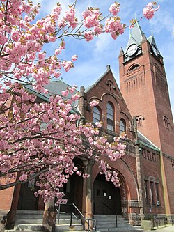
Ware was first settled on Equivalent Lands in 1717 [3] [4] and was officially incorporated in 1775. Its name derives from the word "weir." The native Americans who settled in the area would construct weirs for trapping fish on the Ware River. The English settlers pronounced the word "ware." [3]

In 1716, a tract of land which was slightly more than 11,000 acres (4,500 ha) in size was granted to John Read. He named it "The Manor of Peace" and had it in mind to develop in the style of an English manor, anticipating that it would later become a very valuable country estate. He leased out the land and did not sell 1-acre (4,000 m2) until after his death, when he bequeathed a gift of 200 acres (0.81 km2) to serve as a ministry lot. As time passed, the town of Ware grew up around the old Congregational meeting house and later became a small center of local manufacturing and commerce. [3]

In 1729, the first grist and sawmills were built on the banks of the Weir River by Jabez Olmstead, eventually becoming part of the Ware Millyard Historic District. During the American Revolution, there were at least eight taverns and several inns in the area. Two of the most famous were Ebenezer Nye's tavern and John Downing's. After town meetings were held, they would often adjourn to the latter establishment. By the 1830s, it was not uncommon to see textile mills dotted along the various local rivers. At this point, the Ware community was making the transition from an agrarian economy to an industrially based society. The post Civil War era (1860s–1900s) brought a new prosperity to the now established textile mill town. "Ware factory village", as it was known, sprang up overnight and formed the basis for new growth and development.[ citation needed ]

For nearly 100 years, the Otis company had been the largest single Ware employer. Cotton had been the primary raw material, and by 1937 denims, awnings and tickings were the principal output. It had been very prosperous until World War I, when its employees numbered close to 2,500. By the 1920s, however, the company began to decline due to lack of modern machinery and movement of industry to the south.[ citation needed ]

In 1922, it was affected by the New England Textile Strike, shutting down the mills in the town over an attempted wage cut. [5] [6]

By the mid-thirties, the directors decided to liquidate, although no public announcement was made. Shortly thereafter, the company sold its interests to three "cotton men"—Lawrence W. Robert Jr., Edward J. Heitzeberg, and Paul A. Redmond—all with close connections to Alabama Mills, which owned factories in the South.[ citation needed ]

Instantly, the townspeople rallied to the cause. A public mass meeting was called that evening and plans to raise the necessary cash in order to forestall what appeared to be the imminent ruin of the town were formulated. The citizens of Ware were able to purchase the mills with the backing of the Ware Trust Company. The mills became Ware Industries Inc., and Ware came to be known nationwide as "The Town That Can't Be Licked".[ citation needed ]

The town gained lands in the late 1930s as part of the construction of the Quabbin Reservoir. The reservoir dammed the Swift River in the former town of Enfield, flooding the valley. Four towns—Enfield, Greenwich, Prescott and Dana—were disincorporated in 1938 by this building of the reservoir. Much of Enfield and Greenwich became part of the town of Ware, extending the town's lands northward. Today, the town is home to most of the Winsor Dam and its spillway, and the Goodnough Dike, both of which lie within the Quabbin Reservation. Ware's portion of this land is some of the most accessible land in the reservation, with a large lookout tower atop Quabbin Hill. Ware also bears the morbid distinction of being host to the Quabbin Park Cemetery, where most of the graves in the former towns were relocated to, as well as most of the town monuments.

Ware MA Historic Meeting House.jpg

Historic districts

Geography and transportation

Winsor Dam bridge and spillway Winsor Dam Bridge and Spillway, Ware MA.jpg
Winsor Dam bridge and spillway

According to the United States Census Bureau, the town has a total area of 40.0 square miles (103.5 km2), of which 34.4 square miles (89.0 km2) are land and 5.6 square miles (14.5 km2), or 14.01%, are water. [7] Ware lies at the southern end of the Quabbin Reservoir and the Quabbin Reservation. The reservation lands within town include two islands, the former Little Quabbin Hill and Mount Lizzie, neither of which were covered by the waters of the reservoir. The Swift River forms the western boundary of the town, and the Ware River flows through the southeastern part of the town, meeting in Palmer to form the Chicopee River (along with the Quaboag River), which flows into the Connecticut River. The lands of Ware are hilly between the valleys of the Swift and Ware rivers, and much of the land not surrounding the central part of town is heavily forested, with marshes lining the Ware River in spots. Along the Swift River lies the Herman Covey–Swift River Wildlife Management Area.

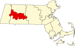
Ware is the easternmost town in Hampshire County and is bordered by Franklin County to the north, Worcester County to the east, and Hampden County to the south. The town is bordered by New Salem to the northwest, Petersham to the north, Hardwick to the northeast, New Braintree and West Brookfield to the east, a small portion of Warren to the southeast, Palmer to the south, and Belchertown to the west. (There is no land link between New Salem or Petersham and Ware due to the Quabbin Reservoir.) Downtown Ware lies 24 miles (39 km) east-southeast of the county seat of Northampton, 26 miles (42 km) northeast of Springfield, 30 miles (48 km) west of Worcester, and 72 miles (116 km) west of Boston.

Ware has no interstates or limited-access highways, the town center being 8.5 miles (13.7 km) north of Exit 63 (the Palmer exit) of Interstate 90. The town is linked to Route 9, the major east-west route through central Massachusetts, by Route 32, which runs concurrently with Route 9 from their merging point to just west of the West Brookfield town line, where Route 32 crosses through the eastern edge of Ware as it heads north. Route 9 heads west through town, passing along the edge of the Quabbin Reservation on its way towards Belchertown. The town has no public transit systems, but does have a commercial rail line, the Massachusetts Central Railroad, which follows the former Ware River Railroad line along the Ware River from Barre to where the line meets the Boston and Albany Railroad lines in Palmer. There is a private general aviation airstrip along Route 32 in the eastern part of town. The nearest national air service airports are Bradley International Airport in Connecticut and Worcester Regional Airport in Massachusetts.

Demographics

Historical population
YearPop.±%
1850 3,785    
1860 3,597−5.0%
1870 4,259+18.4%
1880 4,817+13.1%
1890 7,329+52.1%
1900 8,263+12.7%
1910 8,774+6.2%
1920 8,525−2.8%
1930 7,385−13.4%
1940 7,557+2.3%
1950 7,517−0.5%
1960 7,517+0.0%
1970 8,187+8.9%
1980 8,953+9.4%
1990 9,808+9.5%
2000 9,707−1.0%
2010 9,872+1.7%
2020 10,066+2.0%
2022 [8] 10,385+3.2%

As of the census [9] of 2000, there were 9,707 people, 4,027 households, and 2,597 families residing in the town. The population density was 282.1 inhabitants per square mile (108.9/km2). There were 4,336 housing units at an average density of 126.0 per square mile (48.6/km2). The racial makeup of the town was 96.49% White, 0.55% Black or African American, 0.23% Native American, 0.60% Asian, 0.06% Pacific Islander, 0.76% from other races, and 1.32% from two or more races. Hispanic or Latino of any race were 2.08% of the population.

There were 4,027 households, out of which 29.8% had children under the age of 18 living with them, 46.8% were married couples living together, 12.3% had a female householder with no husband present, and 35.5% were non-families. 29.1% of all households were made up of individuals, and 12.5% had someone living alone who was 65 years of age or older. The average household size was 2.41 and the average family size was 2.96.

In the town, the population was spread out, with 24.7% under the age of 18, 8.1% from 18 to 24, 29.3% from 25 to 44, 22.8% from 45 to 64, and 15.1% who were 65 years of age or older. The median age was 38 years. For every 100 females, there were 94.9 males. For every 100 females aged 18 and over, there were 91.6 males.

The median income for a household in the town was $36,875, and the median income for a family was $45,505. Males had a median income of $37,462 versus $25,733 for females. The per capita income for the town was $18,908. About 8.4% of families and 11.2% of the population were below the poverty line, including 16.8% of those under age 18 and 6.9% of those age 65 or over.

Notable people

See also

Related Research Articles

<span class="mw-page-title-main">New Salem, Massachusetts</span> Town in Massachusetts, United States

New Salem is a town in Franklin County, Massachusetts, United States. The population was 983 at the 2020 census. It is part of the Springfield, Massachusetts Metropolitan Statistical Area.

<span class="mw-page-title-main">Shutesbury, Massachusetts</span> Town in Massachusetts, United States

Shutesbury is a town in Franklin County, Massachusetts, United States. The population was 1,717 at the 2020 census. It is part of the Springfield, Massachusetts Metropolitan Statistical Area.

<span class="mw-page-title-main">Warwick, Massachusetts</span> Town in Massachusetts, United States

Warwick is a town in Franklin County, Massachusetts, United States. The population was 780 at the 2020 census. It is part of the Springfield, Massachusetts Metropolitan Statistical Area.

<span class="mw-page-title-main">Pelham, Massachusetts</span> Town in Massachusetts, United States

Pelham is a town in Hampshire County, Massachusetts, United States. The population was 1,280 at the 2020 census. Its ZIP Code is shared with Amherst.

<span class="mw-page-title-main">Hardwick, Massachusetts</span> Town in Massachusetts, United States

Hardwick is a town in Worcester County, Massachusetts, United States, about 20 miles (32 km) west of the city of Worcester. It had a population of 2,667 at the 2020 census. It includes the villages of Hardwick, Gilbertville, Wheelwright and Old Furnace.

<span class="mw-page-title-main">Petersham, Massachusetts</span> Town in Massachusetts, United States

Petersham is a town in Worcester County, Massachusetts, United States. The population was 1,194 at the 2020 census. Petersham is home to a considerable amount of conservation land, including the Quabbin Reservation, Harvard Forest, the Swift River Reservation, and Federated Women's Club State Forest.

<span class="mw-page-title-main">West Boylston, Massachusetts</span> Town in Massachusetts, United States

West Boylston is a town in Worcester County, Massachusetts, United States and a northern suburb of Worcester. The population was 7,877 at the 2020 census. West Boylston includes the village of Oakdale, located on the opposite side of the Wachusett Reservoir from West Boylston center along Route 140. Although the town was split off from Boylston, it has a larger population than its eastern namesake.

<span class="mw-page-title-main">Bondsville, Massachusetts</span>

Bondsville is an area and former census-designated place (CDP) located in the town of Palmer in Hampden County in the western part of the U.S. state of Massachusetts. The population of the CDP was 1,876 at the 2000 census. It is part of the Springfield, Massachusetts Metropolitan Statistical Area. The village was named after Emelius Bond who first secured the water rights of the Swift River in 1846 to form the Bond Village Manufacturing Company.

<span class="mw-page-title-main">West Springfield, Massachusetts</span> City in Massachusetts, United States

West Springfield is a city in Hampden County, Massachusetts, United States. It is part of the Springfield, Massachusetts Metropolitan Statistical Area. The population was 28,835 at the 2020 United States Census. The city is also known as "West Side", in reference to the fact that it is on the western side of the Connecticut River from Springfield, a fact which played a major part in the town's early history.

<span class="mw-page-title-main">Palmer, Massachusetts</span> City in Massachusetts, United States

Palmer is a city in Hampden County, Massachusetts, United States. The population was 12,448 at the 2020 census. It is part of the Springfield, Massachusetts Metropolitan Statistical Area. Palmer adopted a home rule charter in 2004 with a council-manager form of government. Palmer is one of thirteen Massachusetts municipalities that have city forms of government but retain "The town of" in their official names.

<span class="mw-page-title-main">Belchertown, Massachusetts</span> Town in Massachusetts, United States

Belchertown is a town in Hampshire County, Massachusetts, United States. It is part of the Springfield, Massachusetts Metropolitan Statistical Area. The population was 15,350 at the 2020 census. The town includes the census-designated place of Belchertown. Belchertown was formerly the home of the Belchertown State School. The land on which the school sat is, as of 2016, being redeveloped for mixed uses including residential, commercial and recreational. This includes the 385-acre (156 ha) Lampson Brook Farm, used for community and sustainable agriculture, outdoor recreation, and wildlife preservation.

<span class="mw-page-title-main">Athol, Massachusetts</span> Town in Massachusetts, United States

Athol is a town in Worcester County, Massachusetts, United States. The population was 11,945 at the 2020 census.

<span class="mw-page-title-main">Quabbin Reservoir</span> Massachusetts reservoir which serves the Boston area

The Quabbin Reservoir is the largest inland body of water in Massachusetts, and was built between 1930 and 1939. Along with the Wachusett Reservoir, it is the primary water supply for Boston, 65 miles (105 km) to the east, and 40 other cities and towns in Greater Boston. The Quabbin also supplies water to three towns west of the reservoir and acts as backup supply for three others. By 1989, it supplied water for 2.5 million people, about 40% of the state's population at the time. It has an aggregate capacity of 412 billion US gallons (1,560 GL) and an area of 38.6 square miles (99.9 km2).

<span class="mw-page-title-main">Western Massachusetts</span> Region of Massachusetts, United States

Western Massachusetts, known colloquially as "western Mass," is a region in Massachusetts, one of the six U.S. states that make up the New England region of the United States. Western Massachusetts has diverse topography; 22 colleges and universities including UMass in Amherst, MA, with approximately 100,000 students; and such institutions as Tanglewood, the Springfield Armory, and Jacob's Pillow.

<span class="mw-page-title-main">Greenwich, Massachusetts</span> Town in Massachusetts, United States

Greenwich was a town in Hampshire County, Massachusetts, United States. The town was lost as a result of the formation of the Quabbin Reservoir in order to supply Boston's growing water needs.

<span class="mw-page-title-main">Department of Conservation and Recreation</span> State agency of the Commonwealth of Massachusetts

The Department of Conservation and Recreation (DCR) is a state agency of the Commonwealth of Massachusetts, United States, situated in the Executive Office of Energy and Environmental Affairs. It is best known for its parks and parkways. The DCR's mission is "To protect, promote and enhance our common wealth of natural, cultural and recreational resources for the well-being of all." The agency is the largest landowner in Massachusetts.

<span class="mw-page-title-main">Wachusett Reservoir</span> Second largest body of water in the state of Massachusetts

The Wachusett Reservoir is the second largest body of water in the state of Massachusetts. It is located in central Massachusetts, northeast of Worcester. It is part of the water supply system for metropolitan Boston maintained by the Massachusetts Water Resources Authority (MWRA). It has an aggregate capacity of 65 billion US gallons (250,000,000 m3) and an area of almost 7 square miles (18 km2). Water from the reservoir flows to the covered Norumbega Storage Facility via the Cosgrove Tunnel and the MetroWest Water Supply Tunnel. The reservoir has a maximum depth of 120 feet (37 m) and a mean depth of 48 feet (15 m).

<span class="mw-page-title-main">Quabbin–Swift River Valley</span> Region of Massachusetts, United States

The Quabbin Valley is a region of Massachusetts in the United States. The region consists of the Quabbin Reservoir and accompanying river systems in Franklin, Hampden, Hampshire, and Worcester counties. The area is sometimes known as the Swift River Valley region, a reference to the Swift River, which was dammed to form the reservoir.

<span class="mw-page-title-main">Ware River</span> River in United States of America

The Ware River is a 35.4-mile-long (57.0 km) river in central Massachusetts. It has two forks, its West Branch, which begins in Hubbardston, Massachusetts, and its East Branch, which begins in Westminster, Massachusetts. The Ware River flows southwest through the middle of the state, joins the Quaboag River at Three Rivers, Massachusetts, to form the Chicopee River on its way to the Connecticut River.

<span class="mw-page-title-main">Swift River (Ware River tributary)</span>

The Swift River is a river in Massachusetts. It has an east branch, a west branch, and a middle branch. It is a tributary of the Ware River. Part of it is dammed in the Swift River Valley to form the Quabbin Reservoir serving Boston and Eastern Massachusetts. Several towns were lost when the reservoir was constructed and filled.

References

  1. "Ware - Place Explorer - Data Commons".
  2. "Home". wareps.org.
  3. 1 2 3 http://www.stephenrkatz.com/articles
  4. Historical Collections; John Warner Barber; Dorr; 1841.
  5. Foner, Philip Sheldon; Foner, Philip Sheldon (January 1, 1991). History of the labor movement in the United States. 9: The T.U.E.L. to the end of the Gompers era / by Philip S. Foner. New York: Intl Publ. pp. 19–31. ISBN   978-0-7178-0674-4.
  6. E. Tilden, Leonard (1923). "New England Textile Strike". Monthly Labor Review. 16 (5): 13–36 via JSTOR.
  7. "Geographic Identifiers: 2010 Census Summary File 1 (G001): Ware town, Hampshire County, Massachusetts". American Factfinder. U.S. Census Bureau. Archived from the original on February 13, 2020. Retrieved August 8, 2017.
  8. "City and Town Population Totals: 2020-2022". United States Census Bureau . Retrieved September 5, 2023.
  9. "U.S. Census website". United States Census Bureau . Retrieved 2008-01-31.
  10. Katz, Stephen Robert (2022). Candy Cummings: The Life and Career of the Inventor of the Curveball. Jefferson, NC: McFarland Publishing. ISBN   9 781476 680378.
  11. Katz, Stephen Robert (2017). Ware's Boys of Summer: The Stories of Seven Major League Baseball Players from One Small Central Massachusetts Town. pp. 86–102. ISBN   9 781457 549113.
  12. Katz, Stephen Robert (2017). Ware's Boys of Summer: The Stories of Seven Major League Baseball Players from One Small Central Massachusetts Town. pp. 144–168. ISBN   9 781457 549113.
  13. Katz, Stephen Robert (2017). Ware's Boys of Summer: The Stories of Seven Major League Baseball Players from One Small Central Massachusetts Town. pp. 118–143. ISBN   9 781457 549113.