Enfield, Massachusetts

Last updated

Enfield, Massachusetts
FarewellEnfieldTownHall.png
"The end of Enfield." A photograph of downtown Enfield, after 1938.
Seal of Enfield, Massachusetts.svg
Coordinates: 42°19′0″N72°19′58″W / 42.31667°N 72.33278°W / 42.31667; -72.33278
Country United States
State Massachusetts
County Hampshire
IncorporatedFebruary 15, 1816 [1]
DisincorporatedApril 28, 1938
Time zone UTC-5 (Eastern)
  Summer (DST) Eastern
GNIS feature ID617477 [2]

Enfield was a town in Hampshire County, Massachusetts, United States. The town was lost as a result of the creation of the Quabbin Reservoir.

Contents

History

Incorporated in 1816 from portions of Greenwich and Belchertown. It was named in honor of one of its early settlers, Robert Field. [3] General Joseph Hooker, Union general during the American Civil War, was once a resident, and his grandfather was once a town leader. It was centered at the junction of the east and west branches of the Swift River, and the Athol Branch of the Boston and Albany Railroad ran through the town. The town bordered six other towns - Belchertown, Pelham, Greenwich, Prescott, Ware, and Hardwick.

Enfield was disincorporated on April 28, 1938 and portions of the town were annexed to the adjacent towns of Belchertown, New Salem, Pelham, and Ware. (Not all of the former town is now in Hampshire County: the portion ceded to New Salem is now in Franklin County.) 
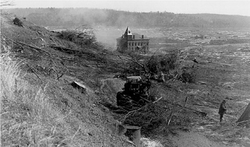
The headquarters of the Metropolitan District Commission during the construction of the Quabbin Reservoir was located in the former town hall, and was the last building razed in the Swift River Valley, in 1940. The majority of the town center now lies submerged beneath the reservoir, although the Quabbin Observatory and Enfield Lookout, located on scenic Quabbin Hill, as well as the main entrance and headquarters of Quabbin State Park, a popular tourist destination with an emphasis on state history and nature, are all within the former town's limits.

Enfield House, an on-campus living facility at Hampshire College in Amherst, Massachusetts, is named after the former town.

More Quabbin towns that were disincorporated

Photos

Related Research Articles

<span class="mw-page-title-main">Hampshire County, Massachusetts</span> County in Massachusetts, United States

Hampshire County is a historical and judicial county located in the U.S. state of Massachusetts. As of the 2020 census, the population was 162,308. Its most populous municipality is Amherst, its largest town in terms of landmass is Belchertown, and its traditional county seat is Northampton. The county is named after the county Hampshire, in England. Hampshire County is part of the Springfield, MA Metropolitan Statistical Area. Together with Hampden County, Hampshire County municipalities belong to the Pioneer Valley Planning Commission.

<span class="mw-page-title-main">New Salem, Massachusetts</span> Town in Massachusetts, United States

New Salem is a town in Franklin County, Massachusetts, United States. The population was 983 at the 2020 census. It is part of the Springfield, Massachusetts Metropolitan Statistical Area.

<span class="mw-page-title-main">Shutesbury, Massachusetts</span> Town in Massachusetts, United States

Shutesbury is a town in Franklin County, Massachusetts, United States. The population was 1,717 at the 2020 census. It is part of the Springfield, Massachusetts Metropolitan Statistical Area.

<span class="mw-page-title-main">Pelham, Massachusetts</span> Town in Massachusetts, United States

Pelham is a town in Hampshire County, Massachusetts, United States. The population was 1,280 at the 2020 census. Its ZIP Code is shared with Amherst.

<span class="mw-page-title-main">Hardwick, Massachusetts</span> Town in Massachusetts, United States

Hardwick is a town in Worcester County, Massachusetts, United States, about 20 miles (32 km) west of the city of Worcester. It had a population of 2,667 at the 2020 census. It includes the villages of Hardwick, Gilbertville, Wheelwright and Old Furnace.

<span class="mw-page-title-main">Petersham, Massachusetts</span> Town in Massachusetts, United States

Petersham is a town in Worcester County, Massachusetts, United States. The population was 1,194 at the 2020 census. Petersham is home to a considerable amount of conservation land, including the Quabbin Reservation, Harvard Forest, the Swift River Reservation, and Federated Women's Club State Forest.

<span class="mw-page-title-main">Belchertown, Massachusetts</span> Town in Massachusetts, United States

Belchertown is a town in Hampshire County, Massachusetts, United States. It is part of the Springfield, Massachusetts Metropolitan Statistical Area. The population was 15,350 at the 2020 census. The town includes the census-designated place of Belchertown. Belchertown was formerly the home of the Belchertown State School. The land on which the school sat is, as of 2016, being redeveloped for mixed uses including residential, commercial and recreational. This includes the 385-acre (156 ha) Lampson Brook Farm, used for community and sustainable agriculture, outdoor recreation, and wildlife preservation.

<span class="mw-page-title-main">Ware, Massachusetts</span> Town in Massachusetts, United States

Ware is a town in Hampshire County, Massachusetts, United States. The population was 10,066 as of 2020. It is part of the Springfield, Massachusetts Metropolitan Statistical Area.

<span class="mw-page-title-main">Quabbin Reservoir</span> Massachusetts reservoir which serves the Boston area

The Quabbin Reservoir is the largest inland body of water in Massachusetts, and was built between 1930 and 1939. Along with the Wachusett Reservoir, it is the primary water supply for Boston, 65 miles (105 km) to the east, and 40 other cities and towns in Greater Boston. The Quabbin also supplies water to three towns west of the reservoir and acts as backup supply for three others. By 1989, it supplied water for 2.5 million people, about 40% of the state's population at the time. It has an aggregate capacity of 412 billion US gallons (1,560 GL) and an area of 38.6 square miles (99.9 km2).

<span class="mw-page-title-main">Western Massachusetts</span> Region of Massachusetts, United States

Western Massachusetts, known colloquially as "western Mass," is a region in Massachusetts, one of the six U.S. states that make up the New England region of the United States. Western Massachusetts has diverse topography; 22 colleges and universities including UMass in Amherst, MA, with approximately 100,000 students; and such institutions as Tanglewood, the Springfield Armory, and Jacob's Pillow.

<span class="mw-page-title-main">Prescott, Massachusetts</span> Town in Massachusetts, United States

Prescott was a town in Hampshire County, Massachusetts, United States. It was incorporated in 1822 from portions of Pelham and New Salem, and was partially built on Equivalent Lands. It was named in honor of Colonel William Prescott, who commanded the American forces at the Battle of Bunker Hill. It was disincorporated on April 28, 1938, as part of the creation of the Quabbin Reservoir. It was the least populous of the four unincorporated towns, with barely 300 residents by 1900. Upon dissolution, portions of the town were annexed to the adjacent towns of New Salem and Petersham. The majority of the former town is still above water, and is known as the Prescott Peninsula. The public is not allowed on the peninsula except for an annual tour given by the Swift River Valley Historical Society, or for hikes conducted by the Society. None of the land is in Hampshire County any longer; the New Salem portion is in Franklin County; and the Petersham portion is in Worcester County.

<span class="mw-page-title-main">Greenwich, Massachusetts</span> Town in Massachusetts, United States

Greenwich was a town in Hampshire County, Massachusetts, United States. The town was lost as a result of the formation of the Quabbin Reservoir in order to supply Boston's growing water needs.

<span class="mw-page-title-main">Dana, Massachusetts</span> Town in Massachusetts, United States

Dana was a town located in Worcester County, Massachusetts, United States. Dana was lost as a result of the formation of the Quabbin Reservoir.

<span class="mw-page-title-main">Massachusetts's 2nd congressional district</span> U.S. House district for Massachusetts

Massachusetts's 2nd congressional district is located in central Massachusetts. It contains the cities of Worcester, which is the second-largest city in New England after Boston, and Northampton in the Pioneer Valley. It is represented by Democrat Jim McGovern.

<span class="mw-page-title-main">Quabbin–Swift River Valley</span> Region of Massachusetts, United States

The Quabbin Valley is a region of Massachusetts in the United States. The region consists of the Quabbin Reservoir and accompanying river systems in Franklin, Hampden, Hampshire, and Worcester counties. The area is sometimes known as the Swift River Valley region, a reference to the Swift River, which was dammed to form the reservoir.

<span class="mw-page-title-main">Massachusetts's 6th congressional district</span> U.S. House district for Massachusetts

Massachusetts's 6th congressional district is located in northeastern Massachusetts. It contains most of Essex County, including the North Shore and Cape Ann, as well as part of Middlesex County. It is represented by Seth Moulton, who has represented the district since January 2015. The shape of the district went through minor changes effective from the elections of 2012 after Massachusetts congressional redistricting to reflect the 2010 census. The towns of Tewksbury and Billerica were added, along with a small portion of the town of Andover.

<span class="mw-page-title-main">Ware River</span> River in United States of America

The Ware River is a 35.4-mile-long (57.0 km) river in central Massachusetts. It has two forks, its West Branch, which begins in Hubbardston, Massachusetts, and its East Branch, which begins in Westminster, Massachusetts. The Ware River flows southwest through the middle of the state, joins the Quaboag River at Three Rivers, Massachusetts, to form the Chicopee River on its way to the Connecticut River.

<span class="mw-page-title-main">Massachusetts Route 21</span> State highway in Massachusetts, US

Route 21 is a 13.73-mile-long (22.10 km) south–north state highway in Massachusetts that runs between U.S. Route 20 and Route 141 in Springfield and Route 9 in Belchertown. Along the way it intersects several major highways including Interstate 90 (I-90) in Ludlow and US 202 and Route 181 in Belchertown.

<span class="mw-page-title-main">Springfield, Athol and North-eastern Railroad</span>

The Springfield, Athol and North–eastern Railroad was a railroad that operated in the northeast United States in the 19th century.

The 155th Massachusetts General Court, consisting of the Massachusetts Senate and the Massachusetts House of Representatives, met from January 1, 1947, to June 18, 1948, during the governorship of Robert F. Bradford, in Boston.

References

  1. Chickering, Jesse (1846). A Statistical View of the Population of Massachusetts, from 1765 to 1840. Boston: Charles C. Little and James Brown. p. 23. Retrieved August 11, 2015.
  2. "Enfield, Massachusetts (historical)". Geographic Names Information System . United States Geological Survey, United States Department of the Interior.
  3. Gannett, Henry (1905). The Origin of Certain Place Names in the United States. Govt. Print. Off. pp.  119.
  4. Jasty, Kunal (December 21, 2014). "A Lost 1996 Interview with David Foster Wallace" . Retrieved February 2, 2018.
  5. Lewis, Alan. "Mark Erelli: Hillbilly Pilgrim" The Boston Globe, January 30, 2004.

Further reading