Goshen, Massachusetts

Last updated

Goshen, Massachusetts
John James Memorial Library, Goshen MA.jpg
John James Memorial Library
Flag of Goshen, Massachusetts.jpg
Seal of Goshen, Massachusetts.gif
Nickname: 
G-Town
Hampshire County Massachusetts incorporated and unincorporated areas Goshen highlighted.svg
Location in Hampshire County in Massachusetts
Coordinates: 42°26′25″N72°48′00″W / 42.44028°N 72.80000°W / 42.44028; -72.80000
Country United States
State Massachusetts
County Hampshire
Settled1761
Incorporated1781
Government
  Type Open town meeting
Area
  Total17.7 sq mi (45.9 km2)
  Land17.4 sq mi (45.0 km2)
  Water0.4 sq mi (0.9 km2)
Elevation
[1]
1,368 ft (417 m)
Population
 (2020)
  Total960
  Density54/sq mi (21/km2)
Time zone UTC−5 (Eastern)
  Summer (DST) UTC−4 (Eastern)
ZIP Code
01032
Area code 413
FIPS code 25-26290
GNIS feature ID0619391 [1]
Website www.goshen-ma.us

Goshen is a town in Hampshire County, Massachusetts, United States. The population was 960 at the 2020 census. [2] It is part of the Springfield, Massachusetts Metropolitan Statistical Area. The town has a rural atmosphere, with one general store, a post office, a fire station, a regional elementary school in nearby Chesterfield, and a town hall. The town encompasses both the Upper and Lower Highland lakes, Upper being a part of the D.A.R. State Forest. The Lower Highland Lake is privately held by a homeowners' association for families who own yearlong and summer properties on the lake.

Contents

History

Goshen was first settled in 1761 and was officially incorporated on May 14, 1781.

Home to natural beryl deposits, colorless beryl was first discovered in Goshen, leading it to be called goshenite by the gem industry.

Parent Town: Chesterfield, Massachusetts.

Historic sites and societies

Demographics

Historical population
YearPop.±%
1850 512    
1860 439−14.3%
1870 368−16.2%
1880 327−11.1%
1890 297−9.2%
1900 316+6.4%
1910 279−11.7%
1920 224−19.7%
1930 248+10.7%
1940 237−4.4%
1950 321+35.4%
1960 385+19.9%
1970 483+25.5%
1980 651+34.8%
1990 830+27.5%
2000 921+11.0%
2010 1,054+14.4%
2020 960−8.9%
2022*947−1.4%
* = population estimate. [3]

As of the census [4] of 2000, there were 921 people, 365 households, and 247 families residing in the town. The population density was 53.0 inhabitants per square mile (20.5/km2). There were 536 housing units at an average density of 30.9 per square mile (11.9/km2). The racial makeup of the town was 99.02% White, 0.11% Native American, 0.22% Asian, and 0.65% from two or more races. Hispanic or Latino of any race were 1.09% of the population.

There were 365 households, out of which 29.9% had children under the age of 18 living with them, 56.2% were married couples living together, 6.8% had a female householder with no husband present, and 32.3% were non-families. Of all households, 18.4% were made up of individuals, and 5.8% had someone living alone who was 65 years of age or older. The average household size was 2.52 and the average family size was 2.94.

In the town, the population was spread out, with 21.9% under the age of 18, 4.3% from 18 to 24, 32.0% from 25 to 44, 31.1% from 45 to 64, and 10.6% who were 65 years of age or older. The median age was 41 years. For every 100 females, there were 88.0 males. For every 100 females age 18 and over, there were 90.2 males.

The median income for a household in the town was $49,583, and the median income for a family was $58,750. Males had a median income of $37,159 versus $27,500 for females. The per capita income for the town was $22,221. About 4.3% of families and 7.9% of the population were below the poverty line, including 7.3% of those under age 18 and 9.5% of those age 65 or over.

Geography

According to the United States Census Bureau, the town has a total area of 17.7 square miles (46 km2), of which 17.4 square miles (45 km2) is land and 0.3 square miles (0.78 km2) (1.98%) is water. Coordinates are 42°26′N72°49′W / 42.44°N 72.81°W / 42.44; -72.81 .

Goshen and Baker, Missouri, are the only two towns or villages in the United States within 29 miles of four different states. Goshen is 28.5 miles from New York, 28 miles from Connecticut, 26 miles from New Hampshire, and 20 miles from Vermont. [5]

Education

Goshen is part of the Hampshire Regional School district along with Chesterfield, Southampton, Westhampton, and Williamsburg. Students in Goshen attend New Hingham Regional Elementary School in Chesterfield from K–6. High School students attend Hampshire Regional High School.

Points of interest

Related Research Articles

<span class="mw-page-title-main">Hampshire County, Massachusetts</span> County in Massachusetts, United States

Hampshire County is a historical and judicial county located in the U.S. state of Massachusetts. As of the 2020 census, the population was 162,308. Its most populous municipality is Amherst, its largest town in terms of landmass is Belchertown, and its traditional county seat is Northampton. The county is named after the county Hampshire, in England. Hampshire County is part of the Springfield, MA Metropolitan Statistical Area. Together with Hampden County, Hampshire County municipalities belong to the Pioneer Valley Planning Commission.

<span class="mw-page-title-main">Cheshire County, New Hampshire</span> County in New Hampshire, United States

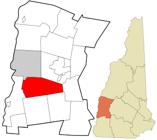
Cheshire County is a county in the southwestern corner of the U.S. state of New Hampshire. As of the 2020 census, the population was 76,458. Its county seat is the city of Keene. Cheshire was one of the five original counties of New Hampshire, and is named for the county of Cheshire in England. It was organized in 1771 at Keene. Sullivan County was created from the northern portion of Cheshire County in 1827.

<span class="mw-page-title-main">Chesterfield, Massachusetts</span> Town in Massachusetts, United States

Chesterfield is a rural hill town in Hampshire County, Massachusetts, United States, 26 miles (42 km) east of Pittsfield and 90 miles (140 km) west of Boston. The population was 1,186 at the 2020 census. It is part of the Springfield, Massachusetts Metropolitan Statistical Area.

<span class="mw-page-title-main">Cummington, Massachusetts</span> Town in Massachusetts, United States

Cummington is a town in Hampshire County, Massachusetts, United States. The population was 829 at the 2020 census, a decline from the figure of 872 tabulated in 2010. It is part of the Springfield, Massachusetts Metropolitan Statistical Area.

<span class="mw-page-title-main">Middlefield, Massachusetts</span> Town in Massachusetts, United States

Middlefield is a town in Hampshire County, Massachusetts, United States. The population was 385 at the 2020 census. It is part of the Springfield, Massachusetts Metropolitan Statistical Area.

<span class="mw-page-title-main">Westhampton, Massachusetts</span> Town in Massachusetts, United States

Westhampton is a town in Hampshire County, Massachusetts, United States. The population was 1,622 at the 2020 census. It is part of the Springfield, Massachusetts Metropolitan Statistical Area.

<span class="mw-page-title-main">Williamsburg, Massachusetts</span> Town in Massachusetts, United States

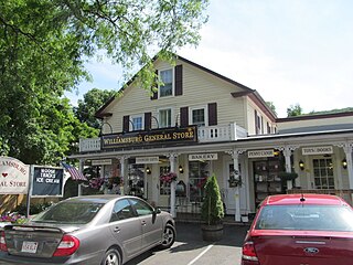
Williamsburg is a town in Hampshire County, Massachusetts, United States. The population was 2,504 at the 2020 census. It is part of the Springfield, Massachusetts Metropolitan Statistical Area.

<span class="mw-page-title-main">Chesterfield, New Hampshire</span> Town in New Hampshire, United States

Chesterfield is a town in Cheshire County, New Hampshire, United States. The population was 3,552 at the 2020 census. It includes the villages of Spofford and West Chesterfield. Chesterfield is home to Spofford Lake, Chesterfield Gorge Natural Area, and parts of Pisgah State Park and Wantastiquet Mountain State Forest.

<span class="mw-page-title-main">Gilsum, New Hampshire</span> Town in New Hampshire, United States

Gilsum is a town in Cheshire County, New Hampshire, United States. The population was 752 at the 2020 census. Home to Bear's Den Natural Area, Gilsum includes Gilsum Lower Village.

<span class="mw-page-title-main">Sullivan, New Hampshire</span> Town in New Hampshire, United States

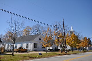
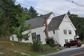
Sullivan is a town in Cheshire County, New Hampshire, United States. The population was 658 at the 2020 census. It includes the villages of East Sullivan and Ellisville.

<span class="mw-page-title-main">Swanzey, New Hampshire</span> Town in New Hampshire, United States

Swanzey is a town in Cheshire County, New Hampshire, United States. The population was 7,270 at the 2020 census. In addition to the town center, Swanzey includes the villages of East Swanzey, West Swanzey, North Swanzey and Westport.

<span class="mw-page-title-main">Westmoreland, New Hampshire</span> Town in New Hampshire, United States

Westmoreland is a town in Cheshire County, New Hampshire, United States. The population was 1,706 at the 2020 census, down from 1,874 at the 2010 census. Westmoreland is historically an agricultural town, with much arable farmland.

<span class="mw-page-title-main">Bridgewater, New Hampshire</span> Town in New Hampshire, United States

Bridgewater is a town in Grafton County, New Hampshire, United States. The population was 1,160 at the 2020 census.

<span class="mw-page-title-main">Groton, New Hampshire</span> Town in New Hampshire, United States

Groton is a town in Grafton County, New Hampshire, United States. The population was 569 at the 2020 census.

<span class="mw-page-title-main">Newbury, New Hampshire</span> Town in New Hampshire, United States

Newbury is a town in Merrimack County, New Hampshire, United States. The population was 2,172 at the 2020 census. Newbury is home to part of Lake Sunapee, including Mount Sunapee State Park Beach. Mount Sunapee Resort, a ski area in Mount Sunapee State Park, is in the west. The town includes the villages of Newbury, Blodgett Landing and South Newbury.

<span class="mw-page-title-main">Salisbury, New Hampshire</span> Town in New Hampshire, United States

Salisbury is a town in Merrimack County, New Hampshire, United States. The population was 1,422 at the 2020 census.

<span class="mw-page-title-main">Acworth, New Hampshire</span> Town in New Hampshire, United States

Acworth is a town in Sullivan County, New Hampshire, United States. At the 2020 census, the town had a total population of 853.

<span class="mw-page-title-main">Goshen, New Hampshire</span> Place in New Hampshire, United States

Goshen is a town in Sullivan County, New Hampshire, United States. The population was 796 at the 2020 census.

<span class="mw-page-title-main">Lempster, New Hampshire</span> Place in New Hampshire, United States

Lempster is a town in Sullivan County, New Hampshire, United States. The population was 1,118 at the 2020 census. Settlements include the town center and the village of East Lempster.

<span class="mw-page-title-main">Unity, New Hampshire</span> Place in New Hampshire, United States

Unity is a town in Sullivan County, New Hampshire, United States. The population was 1,518 at the 2020 census, down from 1,671 at the 2010 census. The town includes the villages of Unity, East Unity, Quaker City, and West Unity.

References

  1. 1 2 U.S. Geological Survey Geographic Names Information System: Goshen, Massachusetts
  2. "Census - Geography Profile: Goshen town, Hampshire County, Massachusetts". United States Census Bureau . Retrieved November 14, 2021.
  3. "City and Town Population Totals: 2020−2022". United States Census Bureau . Retrieved November 24, 2023.
  4. "U.S. Census website". United States Census Bureau . Retrieved January 31, 2008.
  5. From United States Geological Survey sources, which have a small unpopulated area of Cimarron County, Oklahoma, as little as 27 miles from four different states and Goshen, MA and Baker, MO as the only towns or villages within 29 miles of four different states.
  6. Camp Howe Youth Summer Camp
  7. The Institute for the Musical Arts