Stephentown, New York

Last updated

Stephentown, New York
Entering Stephentown NY.jpg
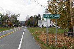
Entering Stephentown
Rensselaer County New York incorporated and unincorporated areas Stephentown highlighted.svg
Location in Rensselaer County and the state of New York.
Coordinates: 42°32′40″N73°24′58″W / 42.54444°N 73.41611°W / 42.54444; -73.41611
Country United States
State New York
County Rensselaer
Area
[1]
  Total58.09 sq mi (150.44 km2)
  Land57.89 sq mi (149.93 km2)
  Water0.20 sq mi (0.51 km2)
Elevation
1,063 ft (324 m)
Population
 (2010)
  Total2,903
  Estimate 
(2016) [2]
2,888
  Density49.89/sq mi (19.26/km2)
Time zone UTC-5 (Eastern (EST))
  Summer (DST) UTC-4 (EDT)
ZIP codes
12168-12169
Area code 518
FIPS code 36-71102
GNIS feature ID0979523
Website Town website

Stephentown is a town in Rensselaer County, New York, United States. The population was 2,903 at the 2010 census. The town, which was originally Jericho Hallow in the Massachusetts Bay Colony, was renamed for Stephen Van Rensselaer. The town is located in the southeastern corner of the county, and has a sign proclaiming it to be the only Stephentown on Earth.

Contents

History

Stephentown was first settled around 1765. The town was formed in 1788, [3] from the East Manor of Rensselaerwyck District. The Stephentown pioneers were from New England, primarily Rhode Island and Connecticut.

Geography

According to the United States Census Bureau, the town has a total area of 58.1 square miles (150 km2), of which 58.0 square miles (150 km2) is land and 0.1 square miles (0.26 km2) (0.16%) is water. The southern town line is the border with Columbia County, New York, and the eastern town boundary is the border of Massachusetts. The western and central portions of the town are part of the Rensselaer Plateau. [4]

Demographics

Historical population
CensusPop.Note
1820 2,592
1830 2,7164.8%
1840 2,7531.4%
1850 2,622−4.8%
1860 2,311−11.9%
1870 2,133−7.7%
1880 1,986−6.9%
1890 1,764−11.2%
1900 1,545−12.4%
1910 1,289−16.6%
1920 1,109−14.0%
1930 1,093−1.4%
1940 1,1818.1%
1950 1,2959.7%
1960 1,3615.1%
1970 1,73127.2%
1980 2,03117.3%
1990 2,52124.1%
2000 2,87314.0%
2010 2,9031.0%
2016 (est.)2,888 [2] −0.5%
U.S. Decennial Census [5]

As of the census [6] of 2010, there were 2,903 people, 1,141 households, and 838 families residing in the town. The population density was 49.8 inhabitants per square mile (19.2/km2). There were 1,339 housing units at an average density of 23.1 per square mile (8.9/km2). The racial makeup of the town was 96.7% White, 0.31% African American, 0.21% Native American, 0.14% Asian, 0.07% Pacific Islander, and 0.77% from two or more races. Hispanic or Latino of any race were 3.11% of the population.

There were 1,141 households, out of which 35.5% had children under the age of 18 living with them, 59.5% were married couples living together, 8.2% had a female householder with no husband present, and 27.2% were non-families. 21.0% of all households were made up of individuals, and 7.2% had someone living alone who was 65 years of age or older. The average household size was 2.54 and the average family size was 2.94.

In the town, the population was spread out, with 25.7% under the age of 18, 6.8% from 18 to 24, 31.1% from 25 to 44, 26.1% from 45 to 64, and 10.4% who were 65 years of age or older. The median age was 38 years. For every 100 females, there were 96.0 males. For every 100 females age 18 and over, there were 99.3 males.

The median income for a household in the town was $59,769, and the median income for a family was $61,347. Males had a median income of $31,535 versus $26,611 for females. The per capita income for the town was $25,352. About 5.7% of families and 6.6% of the population were below the poverty line, including 9.0% of those under age 18 and 7.0% of those age 65 or over.

Communities and locations in Stephentown

Notable people

Electric power facilities

Stephentown Spindle

Pursuant to Section 68 of the Public Service Law, Stephentown Regulating Services LLC (SRS) (now operating as Stephentown Spindle LLC (SS)) was granted a Certificate of Public Convenience and Necessity for a 20-megawatt (MW) flywheel-based energy storage facility in 2009. It went in-service in 2010. There are 200 flywheels set within 20 pods on 5-acres that spin at high rates of speed (8,000 rpm to 16,000 rpm) storing energy as rotational energy. Each flywheel weighs 5 tons. The flywheels are energized by and discharge their energy into the New York State transmission system. [8] [9] [10] [11]

The project was initially financed in 2010 with a $43 million loan from the federal Department of Energy, however, this amount was reduced to $25 million in 2012 when SS acquired the SRS assets. The company does not sell energy into the NYISO's electric wholesale market or capacity market, however, it does receive revenue from the ancillary services market for providing frequency regulation service. The stakeholder-driven policy at the NYISO excludes the facility from providing power into the NYISO's wholesale electric and capacity markets because it does not meet minimum criteria - a minimum of 5 minutes or 1 hour - for sustained energy delivery. The regulation service market in the NYISO provides revenue via two streams, a main regulation capacity price ($/MWh over a five-minute interval in the real-time market) based on a day-ahead and real-time market price, and a movement (performance) award ($/MW). For example, if the facility were able to provide its 20 MW output for 12 hours of the day at an average regulation price of $11 per MWh the facility would receive $963,600 a year. Revenue received from the performance fee, which averaged about $2.30 per MW in Q2 of 2018, is a much smaller proportion of annual revenue. [12] [13] [14] [15] [16]

It is the first commercial flywheel project in the United States to provide frequency regulation service. The only other comparable utility-scale energy storage facilities in New York are NYPA's 1,100 MW pumped storage facility at Blenheim-Gilboa and NYPA's 240 MW Lewiston pumped storage facility at Niagara Falls. For a power comparison, the capital region's peak summer demand was 2,032 MW in 2017. [16]

Related Research Articles

<span class="mw-page-title-main">Bethlehem, New York</span> Town in New York, United States

Bethlehem is a town in Albany County, New York, United States. The town's population was 35,034 at the 2020 census. Bethlehem is located immediately to the south of the city of Albany and includes the following hamlets: Delmar, Elsmere, Glenmont, North Bethlehem, Selkirk, Slingerlands, and South Bethlehem. U.S. Route 9W passes through the town. The town is named after the biblical Bethlehem.

<span class="mw-page-title-main">Guilderland, New York</span> Town in New York, United States

Guilderland is a town in Albany County, New York, United States. In the 2020 census, the town had a population of 36,848. The town is named for the Gelderland province in the Netherlands. The town of Guilderland is on the central-northwest border of the county. It is just west of Albany, the capital of the U.S. state of New York.

<span class="mw-page-title-main">Dover, New York</span> Town in New York, United States

Dover is a town in Dutchess County, New York, United States. The population was 8,415 at the 2020 census. The town was named after Dover in England, the home town of an early settler.

<span class="mw-page-title-main">Berlin, New York</span> Town in New York, United States

Berlin is a town in Rensselaer County, New York, United States. The population was 1,880 at the 2010 census. The town is named after Berlin in Germany, although natives pronounce the name differently, with the accent on the first syllable.

<span class="mw-page-title-main">East Nassau, New York</span> Village in New York, United States

East Nassau is a village in Rensselaer County, New York, United States. The population was 587 at the 2010 census.

<span class="mw-page-title-main">Grafton, New York</span> Town in New York, United States

Grafton is a town in Rensselaer County, New York, United States. The population was 2,130 at the 2010 census. It is believed that the town received its name from Grafton, Vermont, where the first town supervisor, Nathaniel Dumbleton, was originally from. The town is an interior town near the north-central part of the county. NY Route 2 passes across the town.

<span class="mw-page-title-main">Hoosick, New York</span> Town in New York, United States

Hoosick is a town in Rensselaer County, New York, United States. The population was 6,924 at the 2010 census. It was named from the Hoosic River.

<span class="mw-page-title-main">North Greenbush, New York</span> Town in New York, United States

North Greenbush is a town in Rensselaer County, New York, United States. North Greenbush is located in the western part of the county. The population was 13,292 at the 2020 census.

<span class="mw-page-title-main">Petersburgh, New York</span> Town in New York, United States

Petersburgh is a town located in the northeast section of Rensselaer County, New York, United States. The population was 1,525 at the 2010 census. The town was named after an early settler named Peter Simmons.

<span class="mw-page-title-main">Pittstown, New York</span> Town in New York, United States

Pittstown is a town in Rensselaer County, New York, United States. The population was 5,735 at the 2010 census. It is in the northern part of the county.

<span class="mw-page-title-main">Rensselaer, New York</span> City in Rensselaer County, New York, US

Rensselaer is a city in Rensselaer County, New York, United States, and is located on the east side of the Hudson River, directly opposite of Albany. As of the 2020 census, the city population was 9,210. Rensselaer is on the western border of Rensselaer County. The area now known as the City of Rensselaer was settled by the Dutch in the 17th century, who called it t'Greyn Bos, which became Greenbush in English. The city has a rich industrial history stretching back to the 19th century, when it became a major railroad hub; In 2020, Albany-Rensselaer was the ninth busiest Amtrak station in the country and the second busiest in New York State. Rensselaer was one of the earliest locations of the dye industry in the United States, and was the first American location for the production of aspirin.

<span class="mw-page-title-main">Sand Lake, New York</span> Town in New York, United States

Sand Lake is a town in south-central part of Rensselaer County, New York, United States. Sand Lake is about 13 miles east of Albany, New York. As of the 2020 census, the population was 8,348. Within the town are three hamlets: Averill Park, Glass Lake and the hamlet of Sand Lake. Its four lakes are a source of recreation. Many commercial enterprises of the 19th century and into the 20th century relied on power generated from the Wynants Kill Creek and Burden Lake mills. The area is known for its fertile soil for grazing and agriculture.

<span class="mw-page-title-main">Schodack, New York</span> Town in New York, United States

Schodack is a town in Rensselaer County, New York, United States. The population was 12,965 at the 2020 census. The town name is derived from the Mahican word, Escotak. The town is in the southwestern part of the county. Schodack is southeast of Albany, New York.

<span class="mw-page-title-main">Athens, New York</span> Town in New York, United States

Athens is a town in Greene County, New York, United States. The population was 3,916 at the 2020 census. The town of Athens has a village also called Athens. The town is near the eastern edge of the county.

<span class="mw-page-title-main">Nassau, New York</span> Town in Rensselaer County, New York, US

Nassau is a town in Rensselaer County, New York, United States. The population was 4,789 at the 2010 census.

<span class="mw-page-title-main">Schaghticoke, New York</span> Town in New York, United States

SchaghticokeSKAT-i-kohk is a town in Rensselaer County, New York, United States. The population was 7,679 at the 2010 census. It was named for the Schaghticoke, a Native American tribe formed in the seventeenth century from an amalgamation of remnant peoples of eastern New York and New England. The tribe has one of the oldest reservations in the United States, located in what is now Litchfield County, Connecticut. It has been recognized by the state of Connecticut but has not yet achieved federal recognition.

Hosea Moffitt was a U.S. Representative from New York.

<span class="mw-page-title-main">Beacon Power</span>

Beacon Power is an American limited liability company and wholly owned subsidiary of RGA Investments LLC specializing in flywheel-based energy storage headquartered in Tyngsboro, Massachusetts. Beacon designs and develops products aimed at utility frequency regulation for power grid operations.

<span class="mw-page-title-main">Flywheel energy storage</span> Method of storing energy

Flywheel energy storage (FES) works by accelerating a rotor (flywheel) to a very high speed and maintaining the energy in the system as rotational energy. When energy is extracted from the system, the flywheel's rotational speed is reduced as a consequence of the principle of conservation of energy; adding energy to the system correspondingly results in an increase in the speed of the flywheel.

<span class="mw-page-title-main">Flywheel storage power system</span>

A flywheel-storage power system uses a flywheel for energy storage, and can be a comparatively small storage facility with a peak power of up to 20 MW. It typically is used to stabilize to some degree power grids, to help them stay on the grid frequency, and to serve as a short-term compensation storage. Unlike common storage power plants, such as the pumped storage power plants with capacities up to 1000 MWh, the benefits from flywheel storage power plants can be obtained with a facility in the range of a few kWh to several tens of MWh. They are comparable in this application with battery storage power plants.

References

  1. "2016 U.S. Gazetteer Files". United States Census Bureau. Retrieved July 5, 2017.
  2. 1 2 "Population and Housing Unit Estimates" . Retrieved June 9, 2017.
  3. Laws of the State of New York. State of New York. 1788. p. 757. Retrieved August 31, 2009.
  4. "Rensselaer Plateau Association - Maps". Archived from the original on December 24, 2013. Retrieved August 26, 2013.
  5. "Census of Population and Housing". Census.gov. Retrieved June 4, 2015.
  6. "U.S. Census website". United States Census Bureau . Retrieved January 31, 2008.
  7. Eisenstadt, Peter, ed. (2005). The Encyclopedia of New York State. Syracuse University Press: Syracuse, NY. p. 201. ISBN   978-0-8156-0808-0.
  8. "Order Granting a Certificate of Public Convenience and Necessity, Approving Financing and, Providing for Lightened Regulation (case no. 09-E-0628)". dps.ny.gov. October 16, 2009. pp. 1–4, 16–28. Retrieved November 26, 2018.
  9. "Rockland Capital Stephentown Spindle Website". www.rocklandcapital.com. Retrieved November 26, 2018.
  10. Andy Colthorpe (May 8, 2018). "Convergent buys up 40MW of flywheels in New York and Pennsylvania". www.energy-storage.news. Retrieved November 26, 2018.
  11. Joe Desposito (August 2, 2011). "Flywheels Land in Stephentown, New York". www.electricdesign.com. Retrieved November 26, 2018.
  12. NYISO Market Administration and Control Area Service Tariff (MST) Section 15.3
  13. "NYISO Tariff Viewer Website". www.nyiso.com. Retrieved November 27, 2018.
  14. Jie Chen; Pallas LeeVanSchaick; David B. Patton. "Quarterly Report on the New York ISO Electricity Markets Second Quarter of 2018" (PDF). www.potomaceconomics.com. p. 27. Retrieved November 27, 2018.
  15. "US Dept. of Energy Stephentown Spindle Website". www.energy.gov. Retrieved November 26, 2018.
  16. 1 2 "NYISO 2018 Gold Book" (PDF). www.nyiso.com. April 2018. pp. 14, 57, 58, 64. Retrieved November 26, 2018.

Further reading