Rensselaer County is a county in the U.S. state of New York. As of the 2020 census, the population was 161,130. Its county seat is Troy. The county is named in honor of the family of Kiliaen van Rensselaer, the original Dutch owner of the land in the area.

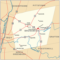
Brunswick is a town in Rensselaer County, New York, United States. The municipality was originally settled in the early 18th century. During its history, it had been part of Albany County, Rensselaerswyck, and Troy, before its incorporation in 1807. It is bordered on the west by the city of Troy; on the north by Schaghticoke and Pittstown; on the east by Grafton; and on the south by Poestenkill and North Greenbush. The population was 11,941 at the 2010 census. The source of the town's name is not certain, though some claim it comes from the source of its first inhabitants from the province of Brunswick-Lüneburg in Germany.

Grafton is a town in Rensselaer County, New York, United States. The population was 2,130 at the 2010 census. It is believed that the town received its name from Grafton, Vermont, where the first town supervisor, Nathaniel Dumbleton, was originally from. The town is an interior town near the north-central part of the county. NY Route 2 passes across the town.

North Greenbush is a town in Rensselaer County, New York, United States. North Greenbush is located in the western part of the county. The population was 13,292 at the 2020 census.

Pittstown is a town in Rensselaer County, New York, United States. The population was 5,735 at the 2010 census. It is in the northern part of the county.

Schodack is a town in Rensselaer County, New York, United States. The population was 12,965 at the 2020 census. The town name is derived from the Mahican word, Escotak. The town is in the southwestern part of the county. Schodack is southeast of Albany, New York.
Wynantskill is a census-designated place (CDP) in Rensselaer County, New York, United States. The population was 3,276 at the 2010 census. Wynantskill is located at the northern town line and the northeastern corner of the town of North Greenbush. The community is a suburb of Troy. state route 66 is the main route through the community. Wynantskill has a major grocery store, several banks and restaurants, a craft beverage store, convenience stores, a post office, and a bowling alley, with almost all houses located on side streets off Main Ave. Other major roads are Whiteview Road, a primarily residential road that leads to US 4; and West Sand Lake Road.

New York State Route 2 (NY 2) is a state highway in the Capital District of New York in the United States. It extends for 30.89 miles (49.71 km) from an interchange with Interstate 87 (I-87) and NY 7 in the town of Colonie to the Massachusetts state line in Petersburgh, where it continues to Boston as Massachusetts Route 2. The route passes through the cities of Watervliet and Troy, where it connects to NY 32 and U.S. Route 4, respectively. In Grafton, located midway between Troy and Massachusetts, NY 2 serves Grafton Lakes State Park.

This list is intended to be a complete compilation of properties and districts listed on the National Register of Historic Places in Rensselaer County, New York, United States. Seven of the properties are further designated National Historic Landmarks.

New York State Route 278 (NY 278) is a state highway in Rensselaer County, New York, in the United States. The route, 1.51 miles (2.43 km) in length, is located in a rural section of the town of Brunswick. It climbs uphill from a southern terminus at NY 2 in the hamlet of Clums Corners to its northern end at NY 7. The road was taken over by the state of New York in 1905 and designated NY 278 c. 1938.
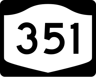
New York State Route 351 (NY 351) is a north–south state highway in central Rensselaer County, New York, in the United States. It extends for 8.16 miles (13.13 km) from an intersection with NY 43 in the Sand Lake hamlet of West Sand Lake to a junction with NY 2 in the Brunswick hamlet of Cropseyville. The portion of NY 351 north of the hamlet of Poestenkill was originally designated as New York State Route 153 in the 1930s. This designation was removed in the 1940s, and the West Sand Lake–Cropseyville roadway became County Route 77 (CR 77) sometime afterward. On April 1, 1980, all of CR 77 was transferred to the state of New York, at which time it was redesignated as NY 351 by the New York State Department of Transportation (NYSDOT).
Speigletown is a hamlet within the town of Schaghticoke, New York in Rensselaer County, New York, United States.
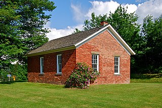
The District #6 Schoolhouse, also known locally as the Little Red Schoolhouse located in Brunswick, New York, United States, is a one-room schoolhouse built c. 1830 or 1837 that was home to grades one through eight until the consolidation of Brunswick (Brittonkill) Central School District in 1952. It was added to the National Register of Historic Places (NRHP) on July 3, 2008 and a dedication ceremony for the accomplishment was held on June 12, 2009.

The District #2 Schoolhouse, known locally as the Garfield School and also known as Brunswick District No. 2 School, located in Brunswick, New York, United States, is a two-room schoolhouse built and opened in 1881. It hosted local students until the consolidation of Brunswick (Brittonkill) Central School District in the mid-1950s. It was added to the National Register of Historic Places (NRHP) in 1988, becoming the first building in the Town of Brunswick to be added to the Register. It is the current home of the Brunswick Historical Society.

The Poesten Kill is a 26.2-mile-long (42.2 km) creek in upstate New York located entirely in Rensselaer County, which flows westerly from its source at Dyken Pond in the town of Berlin to its mouth at the Hudson River in the city of Troy. The Poesten Creek has historically been used as a source of water for the local inhabitants and farmers. In later times it's become even more important as a source of water power during the Industrial Revolution, during which many mills and factories sprung up along its banks
Brunswick Historical Society (BHS) is the local historical society serving the town of Brunswick, New York, United States. It was organized in 1974 and officially chartered in 1981. It moved into its first and current home, the Garfield School in Eagle Mills, in 1988. After sharing the Garfield School with the Brunswick Community Library for more than twenty years, the Library moved to a different location in 2009 and in 2010, BHS expanded into both halves of the former two-room schoolhouse.

The Brick Schoolhouse is a historic one-room schoolhouse at 432 New Hampshire Route 123 in Sharon, New Hampshire. Built in 1832, it is the only of the town's three such buildings to survive, and was the only one made of brick. It is also the only school building now standing in the town, since its students have been schooled in neighboring Peterborough since 1920. The building was listed on the National Register of Historic Places in 2002, and the New Hampshire State Register of Historic Places in 2001.