East Greenbush (CDP), New York

Last updated

East Greenbush, New York
CDP
Rensselaer County New York incorporated and unincorporated areas East Greenbush (CDP) highlighted.svg
Location in Rensselaer County and the state of New York.
USA New York location map.svg
Red pog.svg
East Greenbush, New York
Location within the state of New York
Coordinates: 42°35′33″N73°42′9″W / 42.59250°N 73.70250°W / 42.59250; -73.70250
Country United States
State New York
County Rensselaer
Area
[1]
  Total3.93 sq mi (10.19 km2)
  Land3.92 sq mi (10.15 km2)
  Water0.02 sq mi (0.04 km2)
Elevation
341 ft (104 m)
Population
 (2020)
  Total6,266
  Density1,599.69/sq mi (617.57/km2)
Time zone UTC-5 (Eastern (EST))
  Summer (DST) UTC-4 (EDT)
ZIP code
12061
Area code 518
FIPS code 36-22106
GNIS feature ID0949084

East Greenbush is a census-designated place (CDP) in Rensselaer County, New York, United States. The population was 6,266 at the 2020 census. [2]

Contents

East Greenbush is mostly within the southern part of the town of East Greenbush, but a small section of the community extends southward into the town of Schodack.

U.S. Routes 9 and 20 pass through the community, and the western end of U.S. Route 4 begins immediately north of the community.

Geography

East Greenbush is located at 42°35′33″N73°42′8″W / 42.59250°N 73.70222°W / 42.59250; -73.70222 (42.59263, -73.702402). [3]

According to the United States Census Bureau, the CDP has a total area of 2.7 square miles (6.9 km2), all land.

Demographics

Historical population
CensusPop.Note
2020 6,266
U.S. Decennial Census [4]

As of the census [5] of 2000, there were 4,085 people, 1,568 households, and 1,133 families residing in the CDP. The population density was 1,542.4 inhabitants per square mile (595.5/km2). There were 1,615 housing units at an average density of 609.8 per square mile (235.4/km2). The racial makeup of the CDP was 92.66% White, 3.21% Black or African American, 0.15% Native American, 2.59% Asian, 0.24% from other races, and 1.15% from two or more races. Hispanic or Latino of any race were 1.42% of the population.

There were 1,568 households, out of which 37.2% had children under the age of 18 living with them, 57.8% were married couples living together, 10.9% had a female householder with no husband present, and 27.7% were non-families. 20.9% of all households were made up of individuals, and 5.2% had someone living alone who was 65 years of age or older. The average household size was 2.60 and the average family size was 3.05.

In the CDP, the population was spread out, with 26.6% under the age of 18, 7.0% from 18 to 24, 31.3% from 25 to 44, 25.5% from 45 to 64, and 9.5% who were 65 years of age or older. The median age was 36 years. For every 100 females, there were 91.6 males. For every 100 females age 18 and over, there were 86.8 males.

The median income for a household in the CDP was $92,250, and the median income for a family was $75,375. Males had a median income of $62,610 versus $54,669 for females. The per capita income for the CDP was $74,492. About 2.1% of families and 2.7% of the population were below the poverty line, including 1.3% of those under age 18 and 5.5% of those age 65 or over.

Related Research Articles

<span class="mw-page-title-main">Knightsen, California</span> Census-designated place in California, United States

Knightsen is a census-designated place (CDP) in Contra Costa County, California, in the United States. As of the 2010 census, the CDP population was 1,568, up from 861 reported in the 2000 census.

<span class="mw-page-title-main">Bystrom, California</span> Census-designated place in California, United States

Bystrom is a census-designated place (CDP) in Stanislaus County, California, United States. The population was 4,008 at the 2010 census, down from 4,518 at the 2000 census. It is part of the Modesto Metropolitan Statistical Area.

<span class="mw-page-title-main">Cumberland Center, Maine</span> Census-designated place in Maine, United States

Cumberland Center is a census-designated place (CDP) within the town of Cumberland in Cumberland County, Maine, United States. The population was 2,499 at the 2010 census. It is part of the Portland – South Portland – Biddeford, Maine, Metropolitan Statistical Area.

<span class="mw-page-title-main">Cavetown, Maryland</span> CDP in Maryland, United States

Cavetown is a census-designated place (CDP) in Washington County, Maryland, United States. The population was 1,486 at the 2000 census.

<span class="mw-page-title-main">North Scituate, Massachusetts</span> Census-designated place in Massachusetts, United States

North Scituate is a census-designated place (CDP) in the town of Scituate in Plymouth County, Massachusetts, United States. The population was 5,077 at the 2010 census. It was formerly known as Gannet Corner.

<span class="mw-page-title-main">Holiday City-Berkeley, New Jersey</span> Populated place in Ocean County, New Jersey, US

Holiday City-Berkeley is an unincorporated community and census-designated place (CDP) located within Berkeley Township, in Ocean County, in the U.S. state of New Jersey. As of the 2010 United States Census, the CDP's population was 13,884.

Lorenz Park is a census-designated place (CDP) in Columbia County, New York, United States. The population was 2,001 in 2020, a slight decrease from the 2,001 at the 2020 census.

<span class="mw-page-title-main">Hampton Manor, New York</span> CDP in New York, United States

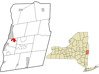
Hampton Manor is a census-designated place in the town of East Greenbush in Rensselaer County, New York, United States. The population was 5,423 at the 2020 census.

<span class="mw-page-title-main">Wynantskill, New York</span> CDP in New York, United States

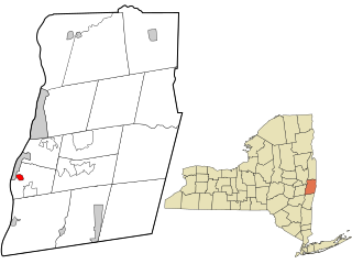
Wynantskill is a census-designated place (CDP) in Rensselaer County, New York, United States. The population was 4,050 at the 2020 census. Wynantskill is located at the northern town line and the northeastern corner of the town of North Greenbush. The community is a suburb of Troy. state route 66 is the main route through the community. Wynantskill has a major grocery store, several banks and restaurants, a craft beverage store, convenience stores, a post office, and a bowling alley, with almost all houses located on side streets off Main Ave. Other major roads are Whiteview Road, a primarily residential road that leads to US 4; and West Sand Lake Road.

<span class="mw-page-title-main">East Glenville, New York</span> Census-designated place in New York, United States

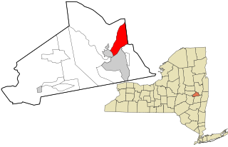
East Glenville is a hamlet in Schenectady County, New York, United States. The population was 6,616 at the 2010 census. The CDP includes the adjacent hamlet of Alplaus.

Northwest Ithaca is a census-designated place (CDP) in Tompkins County, New York, United States. The population was 1,115 at the 2000 census.

<span class="mw-page-title-main">Malden, New York</span> CDP in New York, United States

Malden-on-Hudson (-), commonly known as Malden, is a hamlet in Ulster County, New York, United States. The population was 365 at the 2020 census.

<span class="mw-page-title-main">Valley Falls, Rhode Island</span> Village and census-designated place in Rhode Island, US

Valley Falls is a village and census-designated place (CDP) in the town of Cumberland, Providence County, Rhode Island, United States. The population was 12,094 at the 2020 census.

<span class="mw-page-title-main">Monarch Mill, South Carolina</span> CDP in South Carolina, United States

Monarch Mill is a census-designated place (CDP) in Union County, South Carolina, United States. The population was 1,811 at the 2010 census.

South Shaftsbury is a census-designated place (CDP) in the town of Shaftsbury in Bennington County, Vermont, United States. The population was 681 at the 2020 census.

<span class="mw-page-title-main">Chattaroy, West Virginia</span> Census-designated place in West Virginia, United States

Chattaroy is a census-designated place (CDP) in Mingo County, West Virginia, United States. The population was 756 at the 2010 census.

<span class="mw-page-title-main">Great Barrington (CDP), Massachusetts</span> Census-designated place in Massachusetts, United States

Great Barrington is a census-designated place (CDP) located in the town of Great Barrington in Berkshire County, Massachusetts, United States. The population was 2,231 at the 2010 census, out of 7,104 in the entire town of Great Barrington.

<span class="mw-page-title-main">Ware (CDP), Massachusetts</span> Census-designated place in Massachusetts, United States

Ware is a census-designated place (CDP) comprising the main village in the town of Ware in Hampshire County, Massachusetts, United States. The population of the CDP was 6,170 at the 2010 census, out of a total town population of 9,872. It is part of the Springfield, Massachusetts Metropolitan Statistical Area.

<span class="mw-page-title-main">Lunenburg (CDP), Massachusetts</span> CDP in Massachusetts, United States

Lunenburg is a census-designated place (CDP) in the town of Lunenburg in Worcester County, Massachusetts, United States. The population was 1,760 at the 2010 census.

<span class="mw-page-title-main">Pepperell (CDP), Massachusetts</span> Census-designated place in Massachusetts, United States

Pepperell is a census-designated place (CDP) comprising the main village in the town of Pepperell in Middlesex County, Massachusetts, United States. The population was 2,390 at the 2020 census, out of 11,604 in the entire town of Pepperell.

References

  1. "ArcGIS REST Services Directory". United States Census Bureau. Retrieved September 20, 2022.
  2. United States Census Bureau, 2020 U.S. Census Results, East Greenbush CDP, New York https://www.census.gov/search-results.html?searchType=web&cssp=SERP&q=East%20Greenbush%20CDP,%20New%20York
  3. "US Gazetteer files: 2010, 2000, and 1990". United States Census Bureau. February 12, 2011. Retrieved April 23, 2011.
  4. "Census of Population and Housing". Census.gov. Retrieved June 4, 2016.
  5. "U.S. Census website". United States Census Bureau . Retrieved January 31, 2008.