This article needs additional citations for verification .(September 2014) |
Hampton Manor, New York | |
---|---|
Coordinates: 42°37′8″N73°43′33″W / 42.61889°N 73.72583°W | |
Country | United States |
State | New York |
County | Rensselaer |
Area | |
• Total | 3.02 sq mi (7.82 km2) |
• Land | 3.00 sq mi (7.76 km2) |
• Water | 0.02 sq mi (0.06 km2) |
Elevation | 207 ft (63 m) |
Population (2020) | |
• Total | 5,423 |
• Density | 1,808.87/sq mi (698.50/km2) |
Time zone | UTC-5 (Eastern (EST)) |
• Summer (DST) | UTC-4 (EDT) |
FIPS code | 36-31918 |
GNIS feature ID | 1867405 |
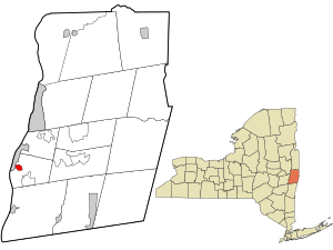
Hampton Manor is a census-designated place in the town of East Greenbush in Rensselaer County, New York, United States. The population was 5,423 at the 2020 census. [2]
Hampton Manor is a suburb of the cities of Rensselaer and Albany. Many of the homes built in Hampton Manor were kit houses from Sears Roebuck and Montgomery Ward. [3]
Hampton Manor is located at 42°37′8″N73°43′33″W / 42.61889°N 73.72583°W (42.618846, -73.725704). [4]
According to the United States Census Bureau, the CDP has a total area of 0.6 square miles (1.6 km2), of which, 0.6 square miles (1.6 km2) of it is land and 0.04 square miles (0.10 km2) of it (3.08%) is water.
Census | Pop. | Note | %± |
---|---|---|---|
2020 | 5,423 | — | |
U.S. Decennial Census [5] |
As of the census [6] of 2000, there were 2,525 people, 1,040 households, and 690 families residing in the CDP. The population density was 4,002.3 inhabitants per square mile (1,545.3/km2). There were 1,079 housing units at an average density of 1,710.3 per square mile (660.4/km2). The racial makeup of the CDP was 95.37% White, 1.70% African American, 0.16% Native American, 1.70% Asian, 0.12% from other races, and 0.95% from two or more races. Hispanic or Latino of any race were 0.71% of the population.
There were 1,040 households, out of which 32.8% had children under the age of 18 living with them, 48.6% were married couples living together, 13.6% had a female householder with no husband present, and 33.6% were non-families. 28.9% of all households were made up of individuals, and 10.6% had someone living alone who was 65 years of age or older. The average household size was 2.40 and the average family size was 2.97.
In the CDP, the population was spread out, with 24.8% under the age of 18, 5.0% from 18 to 24, 32.1% from 25 to 44, 22.8% from 45 to 64, and 15.3% who were 65 years of age or older. The median age was 39 years. For every 100 females, there were 91.9 males. For every 100 females age 18 and over, there were 86.5 males.
The median income for a household in the CDP was $42,794, and the median income for a family was $46,818. Males had a median income of $32,022 versus $30,694 for females. The per capita income for the CDP was $21,589. None of the families and 1.3% of the population were living below the poverty line, including no under eighteens and 4.8% of those over 64.
Saybrook Manor is a community and census-designated place (CDP) in Old Saybrook, a town in Middlesex County, Connecticut, United States. The population was 1,127 at the 2020 census. The Saybrook Manor section is generally the area south of U.S. Route 1 between the Westbrook town line and the Oyster River.
Wilmington Manor is a census-designated place (CDP) in north-eastern New Castle County, Delaware, United States. The population was 7,889 at the 2010 census.
Collegeville is a census-designated place (CDP) in Jasper County, Indiana, United States. The population was 330 at the 2010 census. Collegeville is home to the now-unaccredited Saint Joseph's College, the source of the town's name.
Claverack-Red Mills, commonly known as Claverack, is a census-designated place (CDP) in Columbia County, New York, United States. The population was 953 at the 2020 census.
East Nassau is a village in Rensselaer County, New York, United States. The population was 587 at the 2010 census.
West Sand Lake is a hamlet and census-designated place in Rensselaer County, New York, United States. The population was 2,616 people in 2020. The community is located in the northwestern corner of the town of Sand Lake.
Wynantskill is a census-designated place (CDP) in Rensselaer County, New York, United States. The population was 4,050 at the 2020 census. Wynantskill is located at the northern town line and the northeastern corner of the town of North Greenbush. The community is a suburb of Troy. state route 66 is the main route through the community. Wynantskill has a major grocery store, several banks and restaurants, a craft beverage store, convenience stores, a post office, and a bowling alley, with almost all houses located on side streets off Main Ave. Other major roads are Whiteview Road, a primarily residential road that leads to US 4; and West Sand Lake Road.
Lincolndale is a hamlet and census-designated place (CDP) located in the town of Somers in Westchester County, New York, United States. The population was 1,521 at the 2010 census.
Plymptonville is a census-designated place (CDP) in Clearfield County, Pennsylvania, United States. The population was 972 at the 2020 census.
Fairview-Ferndale is a census-designated place (CDP), located in Coal Township, in Northumberland County, Pennsylvania, United States. The population was 2,411 at the 2000 census.
Shell Point is a census-designated place (CDP) in Beaufort County, South Carolina, United States. The population was 2,336 at the 2010 census. As defined by the U.S. Census Bureau, Shell Point is in the Hilton Head Island−Bluffton, SC Metropolitan Statistical Area.
Wade Hampton is a census-designated place (CDP) in Greenville County, South Carolina, United States. The population was 20,622 at the 2010 census. It is named for American Civil War general and South Carolina governor Wade Hampton.
Eagle Lake is a census-designated place (CDP) in the town of Dover, Racine County, Wisconsin, United States. The population was 1,251 at the 2020 census.
Meadow Acres is a census-designated place (CDP) in Natrona County, Wyoming, United States. It is part of the Casper, Wyoming Metropolitan Statistical Area. The population was 198 at the 2010 census.
Lee is a census-designated place (CDP) located in the town of Lee in Berkshire County, Massachusetts, United States. The population was 2,051 at the 2010 census, out of 5,943 in the entire town of Lee.
East Greenbush is a census-designated place (CDP) in Rensselaer County, New York, United States. The population was 6,266 at the 2020 census.
Nassau is a village located in the Town of Nassau in Rensselaer County, New York, United States. The population was 1,133 at the 2010 census.
Poestenkill is a hamlet in Rensselaer County, New York, United States. The population was 1,061 at the 2010 census. The name is taken from Poesten Kill, a stream in the area.
Schaghticoke is a village in Rensselaer County, New York, United States. The population was 592 at the 2010 census.
Unity is a census-designated place (CDP) in the town of Unity in Waldo County, Maine, United States. The population was 448 at the 2020 census.