
Onondaga County is a county in the U.S. state of New York. As of the 2020 census, the population was 476,516. The county seat is Syracuse. The county is part of the Central New York region of the state.

Rutgers University, officially Rutgers, The State University of New Jersey, is a public land-grant research university consisting of three campuses in New Jersey. Chartered in 1766, Rutgers was originally called Queen's College, and was affiliated with the Dutch Reformed Church. It is the eighth-oldest college in the United States, the second-oldest in New Jersey, and one of nine colonial colleges that were chartered before the American Revolution.

Middlesex County is a county located in the north-central part of the U.S. state of New Jersey, extending inland from the Raritan Valley region to the northern portion of the Jersey Shore. As of the 2020 United States census, the county was the state's third-most populous county with a population of 863,162, its highest decennial count ever and an increase of 53,304 (+6.6%) from the 2010 census count of 809,858, which in turn reflected an increase of 59,696 (8.0%) from the 750,162 counted in the 2000 census. Middlesex is part of the New York metropolitan area. Many communities within the county serve as commuter towns to and from New York City and other points north. The county is part of the Central Jersey region of the state.

Chariton County is a county located in the north-central portion of the U.S. state of Missouri. As of the 2020 census, the population was 7,408. Its county seat is Keytesville. The county was organized November 16, 1820, from part of Howard County and is named for the Chariton River.
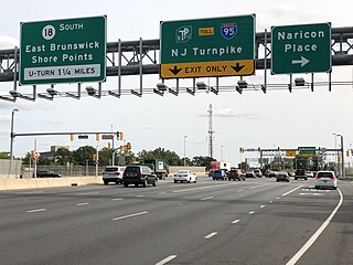
East Brunswick is a township in Middlesex County, in the U.S. state of New Jersey. The suburban bedroom community is part of the New York City metropolitan area and is located on the southern shore of the Raritan River, directly adjacent to the city of New Brunswick and located roughly 29 miles (47 km) away from New York City. As of the 2020 United States census, the township's population was 49,715, its highest decennial count ever and an increase of 2,203 (+4.6%) from the 2010 census count of 47,512, which in turn reflected an increase of 756 (+1.6%) from the 46,756 counted in the 2000 census.
Highland Park is a borough in Middlesex County, in the U.S. state of New Jersey, in the New York City metropolitan area. The borough is located on the northern banks of the Raritan River, in the Raritan Valley region. As of the 2020 United States census, the borough's population was 15,072, an increase of 1,090 (+7.8%) from the 2010 census count of 13,982, which in turn reflected a decline of 17 (−0.1%) from the 13,999 counted in the 2000 census.

New Brunswick is a city in and the county seat of Middlesex County, in the U.S. state of New Jersey. A regional commercial hub for central New Jersey, the city is both a college town and a commuter town for residents commuting to New York City within the New York metropolitan area. New Brunswick is on the Northeast Corridor rail line, 27 miles (43 km) southwest of Manhattan. The city is located on the southern banks of the Raritan River in the heart of the Raritan Valley region.

South Brunswick is a township in Middlesex County, in the U.S. state of New Jersey. The township is centrally located within the Raritan Valley region and is an outer-ring suburb of New York City in the New York metropolitan area. As of the 2020 United States census, the township's population was 47,043, its highest ever decennial census count and an increase of 3,626 (+8.4%) from the 2010 census count of 43,417, which in turn reflected an increase of 5,683 (+15.1%) from the 37,734 counted in the 2000 census.

Brunswick is a town in Rensselaer County, New York, United States. The municipality was originally settled in the early 18th century. During its history, it had been part of Albany County, Rensselaerswyck, and Troy, before its incorporation in 1807. It is bordered on the west by the city of Troy; on the north by Schaghticoke and Pittstown; on the east by Grafton; and on the south by Poestenkill and North Greenbush. The population was 12,581 at the 2020 census. The source of the town's name is not certain, though some claim it comes from the source of its first inhabitants from the province of Brunswick-Lüneburg in Germany.

North Brunswick is a township in Middlesex County, in the U.S. state of New Jersey. It is centrally located in the Raritan Valley region within the New York metropolitan area. As of the 2020 United States census, the township's population was 43,905, an increase of 3,163 (+7.8%) from the 2010 census count of 40,742, which in turn reflected an increase of 3,455 (+12.3%) from the 36,287 counted in the 2000 census.

Central Jersey, or Central New Jersey, is the middle region of the U.S. state of New Jersey. The designation Central Jersey is a distinct administrative toponym. While New Jersey is often divided into North Jersey and South Jersey, many residents recognize Central Jersey as a distinct third entity. As of the 2020 census, Central Jersey has a population of 3,580,999.
East Brunswick High School is a comprehensive public high school serving students in grades ten through twelve in East Brunswick township, Middlesex County, in the U.S. state of New Jersey. It operates as part of East Brunswick Public Schools.

South Brunswick High School (SBHS) is a comprehensive community public high school serving students in ninth through twelfth grades at the school located in the Monmouth Junction section of South Brunswick, in Middlesex County, in the U.S. state of New Jersey, operating as the lone secondary school of the South Brunswick Public Schools. The school has been accredited by the Middle States Association of Colleges and Schools Commission on Elementary and Secondary Schools since 1965.
New Brunswick High School (NBHS) is a four-year comprehensive public high school serving students in ninth through twelfth grades in New Brunswick, in Middlesex County, in the U.S. state of New Jersey, operating as the main secondary school of the New Brunswick Public Schools.
New York State Route 351 (NY 351) is a north–south state highway in central Rensselaer County, New York, in the United States. It extends for 8.16 miles (13.13 km) from an intersection with NY 43 in the Sand Lake hamlet of West Sand Lake to a junction with NY 2 in the Brunswick hamlet of Cropseyville. The portion of NY 351 north of the hamlet of Poestenkill was originally designated as New York State Route 153 in the 1930s. This designation was removed in the 1940s, and the West Sand Lake–Cropseyville roadway became County Route 77 (CR 77) sometime afterward. On April 1, 1980, all of CR 77 was transferred to the state of New York, at which time it was redesignated as NY 351 by the New York State Department of Transportation (NYSDOT).

Clums Corners is a hamlet in the town of Brunswick in Rensselaer County, New York, United States. It is located at the intersection of New York Route 2, New York Route 278, and Tamarac Road. Tamarac Secondary and Elementary Schools are located nearby. The site is so named for the Clum family—specifically James Clum and later his son Orlin—who ran a blacksmith shop during the late 19th century and early 20th century.

Brunswick (Brittonkill) Central School District (BCSD) is a rural fringe central school district located east of the city of Troy whose main campus resides in the town of Brunswick in Rensselaer County, New York, United States. The district has two operating school buildings: Tamarac Elementary School and Tamarac Secondary School. The district is a member of the Rensselaer-Columbia-Greene Boards of Cooperative Educational Services (BOCES), known as Questar III.
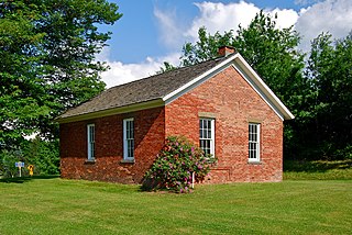
The District #6 Schoolhouse, also known locally as the Little Red Schoolhouse located in Brunswick, New York, United States, is a one-room schoolhouse built c. 1830 or 1837 that was home to grades one through eight until the consolidation of Brunswick (Brittonkill) Central School District in 1952. It was added to the National Register of Historic Places (NRHP) on July 3, 2008 and a dedication ceremony for the accomplishment was held on June 12, 2009.

The District #2 Schoolhouse, known locally as the Garfield School and also known as Brunswick District No. 2 School, located in Brunswick, New York, United States, is a two-room schoolhouse built and opened in 1881. It hosted local students until the consolidation of Brunswick (Brittonkill) Central School District in the mid-1950s. It was added to the National Register of Historic Places (NRHP) in 1988, becoming the first building in the Town of Brunswick to be added to the Register. It is the current home of the Brunswick Historical Society.
Brunswick Historical Society (BHS) is the local historical society serving the town of Brunswick, New York, United States. It was organized in 1974 and officially chartered in 1981. It moved into its first and current home, the Garfield School in Eagle Mills, in 1988. After sharing the Garfield School with the Brunswick Community Library for more than twenty years, the Library moved to a different location in 2009 and in 2010, BHS expanded into both halves of the former two-room schoolhouse.


