West Sand Lake, New York

Last updated

West Sand Lake, New York
Hamlet and CDP
2014-08-28 13 36 57 View west along New York State Route 43 at New York State Route 150 in the West Sand Lake section of Sand Lake, New York.JPG
Intersection of NY 43 and NY 150 in West Sand Lake
Nickname: 
Old Best
Rensselaer County New York incorporated and unincorporated areas West Sand Lake highlighted.svg
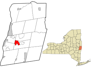
Location in Rensselaer County and the state of New York.
USA New York location map.svg
Red pog.svg
West Sand Lake, New York
Location within the state of New York
Coordinates: 42°38′40″N73°36′21″W / 42.64444°N 73.60583°W / 42.64444; -73.60583
Country United States
State New York
County Rensselaer
Town Sand Lake
Government
  TypeTown Board and Council
  Town SupervisorFlora Fasoldt (D)
Area
[1]
  Total4.86 sq mi (12.58 km2)
  Land4.77 sq mi (12.35 km2)
  Water0.09 sq mi (0.23 km2)
Elevation
525 ft (160 m)
Population
 (2020)
  Total2,616
  Density548.54/sq mi (211.81/km2)
Time zone UTC-5 (Eastern (EST))
  Summer (DST) UTC-4 (EDT)
ZIP code
12196
Area code 518
FIPS code 36-80863 [2]
GNIS feature ID0970858 [3]
Websitewww.TownofSandLake.us

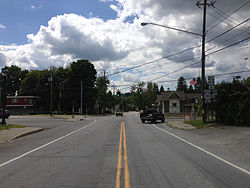
West Sand Lake is a hamlet and census-designated place in Rensselaer County, New York, United States. The population was 2,616 people in 2020. [4] The community is located in the northwestern corner of the town of Sand Lake.

Contents

Geography

West Sand Lake is located at 42°38′40″N73°36′21″W / 42.64444°N 73.60583°W / 42.64444; -73.60583 (42.644579, -73.605928). [5]

According to the United States Census Bureau, the town has a total area of 4.8 square miles (12 km2), of which 4.7 square miles (12 km2) is land and 0.04 square miles (0.10 km2) (0.84%) is water.

Demographics

Historical population
CensusPop.Note
2020 2,616
U.S. Decennial Census [6]

As of 2015, there were 2,845 people living in the town. The population density was 592.71 per square mile. The racial makeup of West Sand Lake was 95.8% Non Hispanic White, 0.2% African American, 0.08% Native American, .6 % Asian, and 1.5% from two or more races. Hispanic or Latino were 1.7% of the population. There were 907 households, out of which 38.0% had children under the age of 18 living with them, 63.2% were married couples living together, 9.2% had a female householder with no husband present, and 24.4% were non-families. 20.2% of all households were made up of individuals, and 9.7% had someone living alone who was 65 years of age or older. The average household size was 2.68 and the average family size was 3.09.

In the CDP, the population was spread out, with 26.8% under the age of 18, 5.9% from 18 to 24, 27.3% from 25 to 44, 28.7% from 45 to 64, and 11.3% who were 65 years of age or older. The median age was 39 years. For every 100 females, there were 93.7 males. For every 100 females age 18 and over, there were 91.9 males.

The median income for a household in West Sand Lake was $85,000, and the median income for a family was $92,367. The per capita income for the town was $36,235 About 5.0% of families and 7.8 of the population were below the poverty line, including 7.4% of those under age 18 and 19.1% of those age 65 or over.

The area has a population density of 592.71 people per sq. mile.

Notable people

Related Research Articles

<span class="mw-page-title-main">Grenada, California</span> Census-designated place (CDP) in Siskiyou County, California, United States

Grenada is a census-designated place (CDP) in Siskiyou County, California, United States. Its population is 314 as of the 2020 census, down from 367 from the 2010 census. The ZIP code is 96038 and the community is within area code 530.

<span class="mw-page-title-main">Cocoa West, Florida</span> CDP in Florida, United States

Cocoa West is a census-designated place (CDP) in Brevard County, Florida, United States. The population was 5,925 at the 2010 census. It is the closest place to Lake Poinsett and Canaveral Groves.

<span class="mw-page-title-main">Channel Lake, Illinois</span> Census-designated place in Illinois, United States

Channel Lake is an unincorporated community and census-designated place (CDP) in Antioch Township, Lake County, Illinois, United States. Per the 2020 census, the population was 1,581.

Forest Lake is an unincorporated community and census-designated place (CDP) in Ela Township of Lake County, Illinois, United States. It is about 35 miles (56 km) northwest of downtown Chicago. Per the 2020 census, the population was 1,784. The community was founded in 1935 as a vacation community for Chicago residents.

Gages Lake is a census-designated place (CDP) in Warren Township, Lake County, Illinois, United States. The population was 10,637 at the 2020 census.

Lake Catherine is an unincorporated community and census-designated place (CDP) in Lake County, Illinois, United States. Per the 2020 census, the population was 1,279.

Venetian Village is a census-designated place (CDP) in Lake County, Illinois, United States. Per the 2020 census, the population was 2,761.

<span class="mw-page-title-main">Housatonic, Massachusetts</span> Census-designated place in Massachusetts, United States

Housatonic is a census-designated place (CDP) in the town of Great Barrington in Berkshire County, Massachusetts, United States. It is part of the Pittsfield, Massachusetts Metropolitan Statistical Area. The population was 1,109 at the 2010 census. It was named after the Housatonic River.

<span class="mw-page-title-main">Pinehurst, Massachusetts</span> Census-designated place in Massachusetts, United States

Pinehurst is an unincorporated village and census-designated place (CDP) in the town of Billerica, Middlesex County, Massachusetts, United States. The population was 7,368 at the 2020 census. It is in the southeastern part of town along Massachusetts Route 3A.

<span class="mw-page-title-main">Parc, New York</span> Census-designated place in New York, United States

Parc is a location and census-designated place in Clinton County, New York, United States. The name "Parc" is derived from the official name for the 3,447-acre (13.95 km2) industrial site, which is PARC, an acronym for the Plattsburgh Airbase Redevelopment Corporation. PARC was established for the purpose of redeveloping the Plattsburgh Air Force Base after it closed on September 25, 1995. PARC is now operated by the Plattsburgh Air Base Development Authority, and the massive airfield is now Plattsburgh International Airport. The population of the Parc CDP was 254 at the 2010 census. Parc is located in the town of Plattsburgh and is bordered to the north by the city of Plattsburgh.

Lorenz Park is a census-designated place (CDP) in Columbia County, New York, United States. The population was 2,001 in 2020, a slight decrease from the 2,001 at the 2020 census.

<span class="mw-page-title-main">Hillside Lake, New York</span> Census-designated place in New York, United States

Hillside Lake is a hamlet and census-designated place (CDP) in Dutchess County, New York, United States. The population was 1,084 at the 2010 census. It is part of the Poughkeepsie–Newburgh–Middletown, NY Metropolitan Statistical Area as well as the larger New York–Newark–Bridgeport, NY-NJ-CT-PA Combined Statistical Area.

<span class="mw-page-title-main">Carmel Hamlet, New York</span> Hamlet and Census-designated place in New York, United States

Carmel Hamlet, commonly known simply as Carmel, is a hamlet and census-designated place (CDP) located in the Town of Carmel in Putnam County, New York, United States. As of the 2010 census, the population was 6,817.

<span class="mw-page-title-main">Wynantskill, New York</span> CDP in New York, United States

Wynantskill is a census-designated place (CDP) in Rensselaer County, New York, United States. The population was 4,050 at the 2020 census. Wynantskill is located at the northern town line and the northeastern corner of the town of North Greenbush. The community is a suburb of Troy. state route 66 is the main route through the community. Wynantskill has a major grocery store, several banks and restaurants, a craft beverage store, convenience stores, a post office, and a bowling alley, with almost all houses located on side streets off Main Ave. Other major roads are Whiteview Road, a primarily residential road that leads to US 4; and West Sand Lake Road.

<span class="mw-page-title-main">Saugerties South, New York</span> CDP in New York, United States

Saugerties South is a hamlet in Ulster County, New York, United States. The population was 2,442 at the 2020 census.

Flying Hills is a census-designated place (CDP) in Cumru Township, Berks County, Pennsylvania. The population was 2,568 as of the 2010 census.

<span class="mw-page-title-main">Eagle Lake, Wisconsin</span> CDP in Wisconsin, United States

Eagle Lake is a census-designated place (CDP) in the town of Dover, Racine County, Wisconsin, United States. The population was 1,251 at the 2020 census.

<span class="mw-page-title-main">Delavan Lake, Wisconsin</span> CDP in Wisconsin, United States

Delavan Lake is a census-designated place (CDP) in the towns of Delavan and Walworth, Walworth County, Wisconsin, United States. The population was 2,803 at the 2020 census. It is located near the shore of Delavan Lake.

<span class="mw-page-title-main">Powers Lake, Wisconsin</span> Census-designated place in Wisconsin, United States

Powers Lake is a census-designated place (CDP) in the towns of Randall and Wheatland, in Kenosha County in the U.S. state of Wisconsin. As of the 2020 census, the CDP had a population of 1,401. Part of the Powers Lake CDP was in Walworth County, but on December 20, 2011, it became part of the village of Bloomfield.

<span class="mw-page-title-main">Pine Plains (CDP), New York</span> Census-designated place in New York, United States

Pine Plains is a hamlet and census-designated place (CDP) in Dutchess County, New York, United States. The population was 1,142 at the 2020 census. It is part of the Poughkeepsie–Newburgh–Middletown, NY Metropolitan Statistical Area as well as the larger New York–Newark–Bridgeport, NY-NJ-CT-PA Combined Statistical Area.

References

  1. "ArcGIS REST Services Directory". United States Census Bureau. Retrieved September 20, 2022.
  2. "U.S. Census website". United States Census Bureau . Retrieved January 31, 2008.
  3. "US Board on Geographic Names". United States Geological Survey. October 25, 2007. Retrieved January 31, 2008.
  4. United States Census Bureau, 2020 U.S. Census Results, West Sand Lake CDP, New York https://www.census.gov/search-results.html?searchType=web&cssp=SERP&q=West%20Sand%20Lake%20CDP,%20New%20York
  5. "US Gazetteer files: 2010, 2000, and 1990". United States Census Bureau. February 12, 2011. Retrieved April 23, 2011.
  6. "Census of Population and Housing". Census.gov. Retrieved June 4, 2016.