Hancock, Massachusetts

Last updated

Hancock, Massachusetts
Round Stone Barn, Hancock Shaker Village MA.jpg
The Round Barn at Hancock Shaker Village
Flag of Hancock, Massachusetts.png
Seal of Hancock, Massachusetts.png
Berkshire County Massachusetts incorporated and unincorporated areas Hancock highlighted.svg
Location in Berkshire County and the state of Massachusetts.
Coordinates: 42°32′35″N73°19′27″W / 42.54306°N 73.32417°W / 42.54306; -73.32417
Country United States
State Massachusetts
County Berkshire
Settled1767
Incorporated1776
Government
  Type Open town meeting
Area
  Total35.8 sq mi (92.6 km2)
  Land35.7 sq mi (92.4 km2)
  Water0.08 sq mi (0.2 km2)
Elevation
1,058 ft (322 m)
Population
 (2020)
  Total757
  Density21/sq mi (8.2/km2)
Time zone UTC-5 (Eastern)
  Summer (DST) UTC-4 (Eastern)
ZIP code
01237 (Lanesborough), 01267 (Williamstown), 01201 (Pittsfield)
Area code 413
FIPS code 25-28180
GNIS feature ID0619421
Website town.hancock.ma.us

Hancock is a town in Berkshire County, Massachusetts, United States. It is part of the Pittsfield, Massachusetts Metropolitan Statistical Area. The population was 757 at the 2020 census. [1]

Contents

History

Hancock was first settled in 1762 as the Plantation of Jericho. The town was officially incorporated in 1776, and renamed for John Hancock.

Hancock is one of only three towns in Massachusetts whose local telephone service was not provided by the former Bell System (instead it is part of the Taconic Telephone Corporation, every one of whose other exchanges is situated in neighboring New York). The other two such towns are Richmond, also in Berkshire County, and Granby, in Hampshire County.

Hancock Shaker Village

Shaker dance and worship Shakers Dancing.jpg
Shaker dance and worship

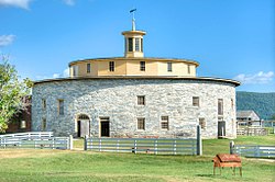
Around 1780, some families in Hancock converted to the teachings of the Shakers. By 1790, Believers in Hancock and Pittsfield established Hancock Shaker Village. The Shakers were a religious order which believed in pacifism, celibacy and communal living. Worship could take the form of singing and ecstatic dance, which is why they were called the "Shaking Quakers", or "Shakers." The utopian sect is renowned today for its plain architecture and furniture. Hancock Shaker Village is famous for its Round Stone Barn, built in 1826. In 1959, the remaining Shakers in Hancock sold the property to a non-profit museum.

Geography

According to the United States Census Bureau, the town has a total area of 35.8 square miles (92.6 km2), of which 35.7 square miles (92.4 km2) is land and 0.077 square miles (0.2 km2), or 0.19%, is water. [2]

Hancock is bordered on the north by Williamstown, on the northeast by New Ashford, on the east by Lanesborough and Pittsfield, on the south by Richmond, and on the west by Canaan, New Lebanon, Stephentown and Berlin, New York.

Most of northern Hancock occupies a valley bound by the Taconic Mountains on each side. The northern half of the valley is drained by the west branch of the Green River, a tributary of the Hoosic River, and the southern half of the valley is drained by the headwaters of Kinderhook Creek, which flows southwest into New York and the Hudson River. To the west, along the New York border, stands the western escarpment of the Taconic Mountains including Misery Mountain and Rounds Mountain, while the northeastern town line is bordered by the eastern Taconic escarpment peaks of Brodie Mountain, Sheeps Heaven Mountain, and Jiminy Peak (home to a ski area of the same name). Southern Hancock, where the Shaker Village is located, is dominated by the Taconic peaks of Pittsfield State Forest, including Tower Mountain, Smith Mountain, Berry Hill, Honwee Mountain, Doll Mountain, and Shaker Mountain. Berry Pond, the highest water body in Massachusetts at over 2,070 feet (630 m) above sea level, sits near the summit of Berry Hill. The highest point in Hancock is a summit of Misery Mountain that reaches 2,671 feet (814 m) above sea level.

U.S. Route 20 passes through the southern end of town, from Pittsfield to the New York state line. Massachusetts Route 43 also passes through town, from the northern border with Williamstown, and is the main route through town, turning along Kinderhook Creek and into New York. There are no roads within the town that connect the two roads, however.

There is no rail, bus or air service within the town. The nearest services are in Pittsfield to the south, and Williamstown and North Adams to the north. The nearest airport with nationally connecting flights is Albany International Airport, approximately 40 miles (64 km) northwest of town.

Demographics

Historical population
YearPop.±%
1850 789    
1860 816+3.4%
1870 882+8.1%
1880 642−27.2%
1890 506−21.2%
1900 451−10.9%
1910 465+3.1%
1920 464−0.2%
1930 361−22.2%
1940 332−8.0%
1950 445+34.0%
1960 455+2.2%
1970 675+48.4%
1980 643−4.7%
1990 628−2.3%
2000 721+14.8%
2010 717−0.6%
2020 757+5.6%
2022*746−1.5%
* = population estimate.
Source: United States census records and Population Estimates Program data. [3] [4] [5] [6] [7] [8] [9] [10] [11] [12] [13]

As of the census [14] of 2000, there were 721 people, 296 households, and 209 families residing in the town. Hancock ranks 25th out of the 32 towns in Berkshire County by population, and 335th out of the 351 in Massachusetts. The population density was 20.2 people per square mile (7.8 people/km2), making it the least densely populated town in Berkshire County, and thirteenth-least in the Commonwealth. There were 472 housing units at an average density of 13.2 per square mile (5.1/km2). The racial makeup of the town was 97.36% White, 0.28% African American, 0.55% Asian, 0.14% from other races, and 1.66% from two or more races. Hispanic or Latino of any race were 1.39% of the population.

There were 296 households, out of which 29.7% had children under the age of 18 living with them, 62.2% were married couples living together, 5.4% had a female householder with no husband present, and 29.1% were non-families. 23.3% of all households were made up of individuals, and 7.4% had someone living alone who was 65 years of age or older. The average household size was 2.41 and the average family size was 2.84.

In the town, the population was spread out, with 24.1% under the age of 18, 3.6% from 18 to 24, 29.8% from 25 to 44, 29.7% from 45 to 64, and 12.8% who were 65 years of age or older. The median age was 40 years. For every 100 females, there were 110.8 males. For every 100 females age 18 and over, there were 96.8 males.

The median income for a household in the town was $45,347, and the median income for a family was $50,625. Males had a median income of $35,000 versus $28,750 for females. The per capita income for the town was $22,250. About 6.1% of families and 5.7% of the population were below the poverty line, including 2.4% of those under age 18 and 9.8% of those age 65 or over.

Government

Taylor Memorial Library Taylor Memorial Library, Hancock MA.jpg
Taylor Memorial Library

Hancock is governed by the open town meeting form of government, and is governed by a board of selectmen. The town has its own volunteer fire department. The town has its own library, Taylor Memorial Library, and other public services.

On the state level, Hancock is represented in the Massachusetts House of Representatives as part of the First Berkshire District, which covers northern and central Berkshire County and has been represented by Gailanne M. Cariddi since January 2013. Prior to the 2010 Massachusetts redistricting of the House and Senate Hancock was in the Second Berkshire District. In the Massachusetts Senate, the town is represented as part of the Berkshire, Hampshire and Franklin district, which includes all of Berkshire County and western Hampshire and Franklin counties, and has been represented by Ben Downing since 2007. [15] The town is patrolled by the Fourth (Cheshire) Station of Troop "B" of the Massachusetts State Police. [16]

On the national level, Hancock is represented in the United States House of Representatives as part of Massachusetts's 1st congressional district, and has been represented by Richard Neal of Springfield since 2013. Massachusetts is currently represented in the United States Senate by senior Senator Elizabeth Warren and junior Senator Ed Markey.

Education

The town has a single school, Hancock Elementary School, which serves students from kindergarten through sixth grade. Upper grades students attend Mount Greylock Regional High School in Williamstown. The nearest private schools are in Williamstown and Pittsfield.

The nearest community college, Berkshire Community College, is in Pittsfield. The nearest state colleges are Westfield State University and Massachusetts College of Liberal Arts in North Adams, and the nearest University of Massachusetts campus is the UMass Amherst. Williams College in Williamstown is the nearest private college.

See also

Related Research Articles

<span class="mw-page-title-main">Berkshire County, Massachusetts</span> County in Massachusetts, United States

Berkshire County is the westernmost county in the U.S. state of Massachusetts. As of the 2020 census, the population was 129,026. Its largest city and traditional county seat is Pittsfield. The county was founded in 1761. The Berkshire Hills are centered on Berkshire County. Residents are known as Berkshirites. It exists today only as a historical geographic region, and has no county government, with the exception of the retirement board for former county workers, and certain offices such as the sheriff and registry of deeds.

<span class="mw-page-title-main">Alford, Massachusetts</span> Town in Massachusetts, United States

Alford is a town in Berkshire County, Massachusetts, United States. It is part of the Pittsfield, Massachusetts Metropolitan Statistical Area. The population was 486 at the 2020 census.

<span class="mw-page-title-main">Becket, Massachusetts</span> Town in Massachusetts, United States

Becket is a town in Berkshire County, Massachusetts, United States. It is part of the Pittsfield, Massachusetts Metropolitan Statistical Area. The population was 1,931 at the 2020 census.

<span class="mw-page-title-main">Clarksburg, Massachusetts</span> Town in Massachusetts, United States

Clarksburg is a town in Berkshire County, Massachusetts, United States. It is part of the Pittsfield, Massachusetts Metropolitan Statistical Area. The population was 1,657 at the 2020 census.

<span class="mw-page-title-main">Dalton, Massachusetts</span> Town in Massachusetts, United States

Dalton is a town in Berkshire County, Massachusetts, United States. Dalton is a transition town between the urban and rural portions of Berkshire County. It is part of the Pittsfield, Massachusetts Metropolitan Statistical Area. The population was 6,330 at the 2020 census.

<span class="mw-page-title-main">Egremont, Massachusetts</span> Town in Massachusetts, United States

Egremont is a town in Berkshire County, Massachusetts, United States. It is part of the Pittsfield, Massachusetts Metropolitan Statistical Area. The population was 1,372 at the 2020 census. Egremont consists of two villages, North Egremont and South Egremont, and their outlying areas, which are mostly lightly settled forests and farmland.

<span class="mw-page-title-main">Florida, Massachusetts</span> Town in Massachusetts, United States

Florida is a town in Berkshire County, Massachusetts, United States. It is part of the Pittsfield, Massachusetts Metropolitan Statistical Area. It is home to the east portal of the Hoosac Tunnel, as well as Whitcomb Summit, the highest point of the Mohawk Trail. Florida contains the village of Drury. At the 2020 census the town had a total population of 694. Despite the town’s name, Florida is statistically the coldest and snowiest town in Massachusetts.

<span class="mw-page-title-main">Hinsdale, Massachusetts</span> Town in Massachusetts, United States

Hinsdale is a town in Berkshire County, Massachusetts, United States. It is part of the Metropolitan Statistical Area of Pittsfield, Massachusetts. The population was 1,919 at the 2020 census.

<span class="mw-page-title-main">Lanesborough, Massachusetts</span> Town in Massachusetts, United States

Lanesborough is a town in Berkshire County, Massachusetts, United States. It is part of the Pittsfield, Massachusetts Metropolitan Statistical Area. The population was 3,038 at the 2020 census.

<span class="mw-page-title-main">Mount Washington, Massachusetts</span> Town in Massachusetts, United States

Mount Washington is a town in Berkshire County, Massachusetts, United States. It is part of the Pittsfield, Massachusetts Metropolitan Statistical Area. The population was 160 at the 2020 census, making it the least populous town in Berkshire County and, after Gosnold and Monroe, the third least populous in Massachusetts. The name of the town is a tribute to George Washington, who at the time of incorporation was Commander-in-Chief of the Continental Army during the American Revolutionary War.

<span class="mw-page-title-main">New Ashford, Massachusetts</span> Town in Massachusetts, United States

New Ashford is a town in Berkshire County, Massachusetts, United States. It is part of the Pittsfield, Massachusetts Metropolitan Statistical Area. The population was 250 at the 2020 census.

<span class="mw-page-title-main">Otis, Massachusetts</span> Town in Massachusetts, United States

Otis is a town in Berkshire County, Massachusetts, United States. It is part of the Pittsfield, Massachusetts, Metropolitan Statistical Area. The population was 1,634 at the 2020 census.

<span class="mw-page-title-main">Peru, Massachusetts</span> Town in Massachusetts, United States

Peru is a town in Berkshire County, Massachusetts, United States. The population was 814 at the 2020 census.

<span class="mw-page-title-main">Richmond, Massachusetts</span> Town in Massachusetts, United States

Richmond is a town in Berkshire County, Massachusetts, United States. It is part of the Pittsfield, Massachusetts Metropolitan Statistical Area. The population was 1,407 at the 2020 census.

<span class="mw-page-title-main">Savoy, Massachusetts</span> Town in Massachusetts, United States

Savoy is a town in Berkshire County, Massachusetts, United States. It is part of the Pittsfield, Massachusetts Metropolitan Statistical Area. The population was 645 at the 2020 census.

<span class="mw-page-title-main">Sheffield, Massachusetts</span> Town in Massachusetts, United States

Sheffield is a town in Berkshire County, Massachusetts, United States. It is part of the Pittsfield, Massachusetts, Metropolitan Statistical Area. The population was 3,327 at the 2020 census. Sheffield is home to Berkshire School, a private preparatory school. The former resort town includes the village of Ashley Falls, and is bordered by various other towns and villages, such as Egremont and Great Barrington. Its southern border is the Massachusetts-Connecticut state line.

<span class="mw-page-title-main">Washington, Massachusetts</span> Town in Massachusetts, United States

Washington is a town in Berkshire County, Massachusetts, United States. It is part of the Pittsfield, Massachusetts, Metropolitan Statistical Area. The population was 494 at the 2020 census.

<span class="mw-page-title-main">Windsor, Massachusetts</span> Town in Massachusetts, United States

Windsor is a town in Berkshire County, Massachusetts, United States. It is part of the Pittsfield, Massachusetts Metropolitan Statistical Area. The population was 831 at the 2020 census.

<span class="mw-page-title-main">Williamstown, Massachusetts</span> Town in Massachusetts, United States

Williamstown is a town in Berkshire County, Massachusetts, United States. It shares a border with Vermont to the north and New York to the west. Located in Berkshire County, the town is part of the Pittsfield, Massachusetts metropolitan statistical area. The population was 7,513 at the 2020 census. A college town, it is home to Williams College, the Clark Art Institute and the Tony-awarded Williamstown Theatre Festival.

<span class="mw-page-title-main">Adams, Massachusetts</span> Town in Massachusetts, United States

Adams is a town in northern Berkshire County, Massachusetts, United States. It is part of the Pittsfield, Massachusetts Metropolitan Statistical Area. The population was 8,166 at the 2020 census.

References

  1. "Census - Geography Profile: Hancock town, Berkshire County, Massachusetts". United States Census Bureau . Retrieved November 14, 2021.
  2. "Geographic Identifiers: 2010 Demographic Profile Data (G001): Hancock town, Berkshire County, Massachusetts". U.S. Census Bureau, American Factfinder. Archived from the original on February 12, 2020. Retrieved December 19, 2013.
  3. "Total Population (P1), 2010 Census Summary File 1". American FactFinder, All County Subdivisions within Massachusetts. United States Census Bureau. 2010.
  4. "Massachusetts by Place and County Subdivision - GCT-T1. Population Estimates". United States Census Bureau. Retrieved July 12, 2011.
  5. "1990 Census of Population, General Population Characteristics: Massachusetts" (PDF). US Census Bureau. December 1990. Table 76: General Characteristics of Persons, Households, and Families: 1990. 1990 CP-1-23. Retrieved July 12, 2011.
  6. "1980 Census of the Population, Number of Inhabitants: Massachusetts" (PDF). US Census Bureau. December 1981. Table 4. Populations of County Subdivisions: 1960 to 1980. PC80-1-A23. Retrieved July 12, 2011.
  7. "1950 Census of Population" (PDF). Bureau of the Census. 1952. Section 6, Pages 21-10 and 21-11, Massachusetts Table 6. Population of Counties by Minor Civil Divisions: 1930 to 1950. Retrieved July 12, 2011.
  8. "1920 Census of Population" (PDF). Bureau of the Census. Number of Inhabitants, by Counties and Minor Civil Divisions. Pages 21-5 through 21-7. Massachusetts Table 2. Population of Counties by Minor Civil Divisions: 1920, 1910, and 1920. Retrieved July 12, 2011.
  9. "1890 Census of the Population" (PDF). Department of the Interior, Census Office. Pages 179 through 182. Massachusetts Table 5. Population of States and Territories by Minor Civil Divisions: 1880 and 1890. Retrieved July 12, 2011.
  10. "1870 Census of the Population" (PDF). Department of the Interior, Census Office. 1872. Pages 217 through 220. Table IX. Population of Minor Civil Divisions, &c. Massachusetts. Retrieved July 12, 2011.
  11. "1860 Census" (PDF). Department of the Interior, Census Office. 1864. Pages 220 through 226. State of Massachusetts Table No. 3. Populations of Cities, Towns, &c. Retrieved July 12, 2011.
  12. "1850 Census" (PDF). Department of the Interior, Census Office. 1854. Pages 338 through 393. Populations of Cities, Towns, &c. Retrieved July 12, 2011.
  13. "City and Town Population Totals: 2020−2022". United States Census Bureau . Retrieved November 24, 2023.
  14. "U.S. Census website". United States Census Bureau . Retrieved January 31, 2008.
  15. "Senators and Representatives by City and Town". Archived from the original on September 29, 2007. Retrieved February 23, 2008.
  16. Station B-4, SP Cheshire