
Deerfield is a town in Franklin County, Massachusetts, United States. Settled near the Connecticut River in the 17th century during the colonial era, the population was 5,090 as of the 2020 census. Deerfield is part of the Springfield, Massachusetts Metropolitan Statistical Area in western Massachusetts, lying 30 miles (48 km) north of the city of Springfield.

Turners Falls is an unincorporated village and census-designated place in the town of Montague in Franklin County, Massachusetts, United States. The population was 4,512 at the 2020 census. It is part of the Springfield, Massachusetts Metropolitan Statistical Area. Its name is sometimes used as a metonym for the entire town of Montague, for which it is the business district and comprises more than half the population.

The Pioneer Valley is the colloquial and promotional name for the portion of the Connecticut River Valley that is in Massachusetts in the United States. It is generally taken to comprise the three counties of Hampden, Hampshire, and Franklin. The lower Pioneer Valley corresponds to the Springfield, Massachusetts metropolitan area, the region's urban center, and the seat of Hampden County. The upper Pioneer Valley region includes the smaller cities of Northampton and Greenfield, the county seats of Hampshire and Franklin counties, respectively.

The Connecticut River is the longest river in the New England region of the United States, flowing roughly southward for 406 miles (653 km) through four states. It rises 300 yards south of the U.S. border with Quebec, Canada, and discharges at Long Island Sound. Its watershed encompasses 11,260 square miles (29,200 km2), covering parts of five U.S. states and one Canadian province, via 148 tributaries, 38 of which are major rivers. It produces 70% of Long Island Sound's fresh water, discharging at 18,400 cubic feet (520 m3) per second.
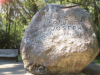
Fort Saint Joseph was a fort established on land granted to the Jesuits by King Louis XIV; it was located on what is now the south side of the present-day town of Niles, Michigan. Père Claude-Jean Allouez established the Mission de Saint-Joseph in the 1680s. Allouez ministered to the local Native Americans, who were primarily Odawa and Ojibwe.

The Mohawk Trail began as a Native American trade route which connected Atlantic tribes with tribes in Upstate New York and beyond. It followed the Millers River, Deerfield River and crossed the Hoosac Range, in the area that is now northwestern Massachusetts.

The Farmington River is a river, 46.7 miles (75.2 km) in length along its main stem, located in northwest Connecticut with major tributaries extending into southwest Massachusetts. The longest route of the river, from the origin of its West Branch, is 80.4 miles (129.4 km) long, making it the Connecticut River's longest tributary by 2.3 miles (3.7 km) over the major river directly to its north, the Westfield River. The Farmington River's watershed covers 609 square miles (1,580 km2). Historically, the river played an important role in small-scale manufacturing in towns along its course, but it is now mainly used for recreation and drinking water.

The Sunken Village Archeological Site, designated by the Smithsonian trinomial 35MU4, is an archaeological site on Sauvie Island in Multnomah County, Oregon, United States. The site consists of a remarkably well-preserved Chinookan village, dating back more than 700 years. It is a major example of a wet archaeological site, in which cultural materials were preserved in an anaerobic freshwater environment. Finds at the site include well-preserved basketry. The site was declared a National Historic Landmark in 1989.

Colonial Pemaquid State Historic Site is a publicly owned historic property operated by the state of Maine near Pemaquid Beach in Bristol, Maine. The site includes the reconstructed Fort William Henry, archaeological remains of 17th- and 18th-century village buildings and fortifications, and a museum with artifacts found on the site including musket balls, coins, pottery, and early hardware.

Cedar Swamp Archeological District is a prehistoric and historic archaeologically sensitive area in eastern Westborough, Massachusetts, and extending into the northwest corner of Hopkinton. Cedar Swamp is an area of more than 2,600 acres (1,100 ha) of wetlands that include the headwaters area of the Sudbury River. Archeological surveys of the environmentally sensitive and critical area have identified many Native American sites of interest. It is believed that Native Americans prized wood from the cedar trees that grew in the area. The archeological district, which encompasses much of the Cedar Swamp area, was added to the National Register of Historic Places in 1988.
The DEDIC or DEDIC/Sugarloaf Site is a paleo-Indian Clovis-era archaeological site in South Deerfield, Massachusetts. It encompasses an area of the Connecticut and Deerfield River valleys containing evidence of relatively large-scale human habitation dating back some 10,000 years. It is located in the general vicinity of Mount Sugarloaf. Part of it is set on the lip of a ravine, apparently a site that the natives used as a kill site, since it served as a choke point in the movements of large animals. It was added to the National Register of Historic Places in 1980.

The Hadley Center Historic District is an expansive, 2,500-acre (1,000 ha) historic district encompassing the village center of Hadley, Massachusetts. When it was first listed on the National Register of Historic Places in 1977, the district encompassed the town green and 17 buildings that faced it, at the junction of Russell Street and Middle Street. The district was expanded significantly in 1994, adding more than 400 buildings representative of the village's growth from colonial days into the first decades of the 20th century. This expansion encompasses the entirety of a tongue of land extending west from East Street and bounded by a bend in the Connecticut River, which separates Hadley from Northampton. Its oldest property, the Samuel Porter House on West Street, was built in 1713.

The Battle of Turner's Falls or Battle of Grand Falls; also known as the Peskeompscut-Wissantinnewag Massacre, was a battle and massacre occurring on May 19, 1676, in the context of King Philip's War in what is present-day Gill and Greenfield, across from Turners Falls on the Connecticut River. The incident marked a turning point in the war, and in the colonization of Native lands by British settlers. The war led to the expulsion of most Native Americans in the Connecticut River Valley.

The Fall River is a 14.1-mile-long (22.7 km) river in southern Vermont and northern Massachusetts, joining the Connecticut River just downstream from Turners Falls, Massachusetts.

The Bellows Falls Petroglyph Site is an archaeological site containing panels of precontact Native American petroglyphs in Bellows Falls, Vermont. Located near the Vilas Bridge on bedrock west of and above the Connecticut River, adjacent to Great Falls, they depict a rarely-seen assemblage of anthropomorphic figures that is believed to be unique in New England, and uncommon even in surrounding geographic areas. The site was listed on the National Register of Historic Places in 1990.

Aquadoctan was one of the largest known Native American villages in what is now the U.S. state of New Hampshire. In an area commonly known today as The Weirs, the village lay on the north bank of the Winnipesaukee River at the outlet of Lake Winnipesaukee in the Lakes Region of New Hampshire. The site is now in Weirs Beach, a summer resort and village of the city of Laconia. The Native American village, whose archaeological remains extend for a half mile along the river and a quarter mile along the lake, has been documented through archaeological investigation to have evidence of settlement from 9,000 BCE to the late seventeenth century. Colonial reports document that the site was abandoned substantially in 1696, when most of New Hampshire's remaining native population withdrew to join the Pequawket at present-day Fryeburg, Maine.

The Lochmere Archeological District is a large archeological area on the banks of the Winnipesaukee River in Belknap County, New Hampshire, near the village of Lochmere. The area, part of which is now preserved by the state as the Brennick Lochmere Archaeological Site, is a multi-component site with evidence of human occupation from the Middle Archaic through the Late Woodland periods. The site was occupied in historic times by the Winnipesaukee sub-tribe of the Pennacook people, and is near Aquadoctan, one of the largest native towns of prehistoric New Hampshire.

The Westminster Terrace Historic District encompasses a locally architecturally distinctive residential area on Westminster Terrace in Bellows Falls and Westminster, Vermont. First developed between about 1880 and 1910, the neighborhood has high-quality late 19th-century homes, interspersed with later mid-20th century development. It was listed on the National Register of Historic Places in 2010.

The Barkhamsted Lighthouse was a historical community located in what is now Peoples State Forest in Barkhamsted, Connecticut. Set on a terrace above the eastern bank of the West Branch Farmington River, it was in the 18th and 19th centuries a small village of economically marginalized mixed Native American, African American, and white residents. It was given the name "lighthouse" because its lights acted as a beacon marking the north–south stage road that paralleled the river. The archaeological remains of the village site were listed on the National Register of Historic Places in 1991 as Lighthouse Archeological Site (5-37).
The Riverside Village Historic District encompasses a village community near Massachusetts Route 2 in Gill, Massachusetts. The district was listed on the National Register of Historic Places in 1992.

