
Deerfield is a town in Franklin County, Massachusetts, United States. Settled near the Connecticut River in the 17th century during the colonial era, the population was 5,090 as of the 2020 census. Deerfield is part of the Springfield, Massachusetts Metropolitan Statistical Area in western Massachusetts, lying 30 miles (48 km) north of the city of Springfield.

Shelburne is a town in Franklin County, Massachusetts, United States. The population was 1,884 at the 2020 census. It is part of the Springfield, Massachusetts Metropolitan Statistical Area.

Mount Auburn Cemetery, located in Cambridge and Watertown, Massachusetts, is the first rural or garden cemetery in the United States. It is the burial site of many prominent Boston Brahmins, and is a National Historic Landmark.

Historic Deerfield is a museum dedicated to the heritage and preservation of Deerfield, Massachusetts, and history of the Connecticut River Valley. Its historic houses, museums, and programs provide visitors with an understanding of New England's historic villages and countryside. It is located in the village of Old Deerfield which has been designated a National Historic Landmark District, and is listed on the National Register of Historic Places. The museum also hosts the Dublin Seminar for New England Folklife.

The Mohawk Trail began as a Native American trade route which connected Atlantic tribes with tribes in Upstate New York and beyond. It followed the Millers River, Deerfield River and crossed the Hoosac Range, in the area that is now northwestern Massachusetts.

The Old Ship Church is a Puritan church built in 1681 in Hingham, Massachusetts. It is the only surviving 17th-century Puritan meetinghouse in the United States. Its congregation, gathered in 1635 and officially known as First Parish in Hingham, occupies the oldest church building in continuous ecclesiastical use in the country. On October 9, 1960, it was designated a National Historic Landmark, and on November 15, 1966, it was added to the National Register of Historic Places.
Hubbard House may refer to:

The Ancient Burying Ground is a historical cemetery at Phinney's Lane in Barnstable, Massachusetts. It is the oldest cemetery in the village of Centerville, and the only surviving civic element of its colonial origins. was listed on the National Register of Historic Places in 1987.

Prospect Hill Cemetery is a historic cemetery on Auburn Road in Millis, Massachusetts. Founded in 1714, it is the town's only cemetery. Covering more than 18 acres (7.3 ha), it has more than 2,800 burials. Among those buried in the cemetery are politician Christian Herter, who served as U.S. Secretary of State and Governor of Massachusetts, and two Medal of Honor recipients, Charles Church Roberts and William D. Newland. The cemetery was listed on the National Register of Historic Places in 2006 with the help of a short documentary film by a Millis High School Freshman Dustin Fresh.

North Cemetery is a historic cemetery in Worthington, Massachusetts. The 3.5-acre (1.4 ha) municipal cemetery is located at the corner of Cold and North Streets not far from Worthington Corners; it is the town's largest cemetery. The cemetery was listed on the National Register of Historic Places in 2004, for its funerary architecture and its role as the burial ground for the town's early settlers.
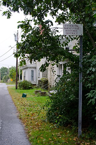
The Barneyville Historic District is a predominantly residential historic district on Old Providence and Barneyville Roads in northwestern Swansea, Massachusetts. The area was the site of a successful shipbuilding operation during the early 19th century, and then became a local center for jewelry making. The district was added to the National Register of Historic Places in 1990.

The Granville Center Historic District is a historic district encompassing the historic center of Granville, Massachusetts. The cluster of buildings in the village center includes the Congregational church, and a number of Federal and Greek Revival residences. The district was listed on the National Register of Historic Places in 1991.

The Old Chestnut Hill Historic District encompasses the historic residential heart of the Newton portion of Chestnut Hill, Massachusetts. When first listed on the National Register of Historic Places in 1986, the district extended along Hammond Street, between Beacon Street and the MBTA Green Line right-of-way, and along Chestnut Hill Road between Hammond and Essex, including properties along a few adjacent streets. The district was expanded in 1990 to include more of Chestnut Hill Road and Essex Road, Suffolk Road and the roads between it and Hammond, and a small section south of the Green Line including properties on Hammond Street, Longwood Road, and Middlesex Road. A further expansion in 1999 added a single property on Suffolk Road.

The Brookline Town Green Historic District encompasses the historic colonial heart of the town of Brookline, Massachusetts. Centered on a stretch of Walnut Street between Warren and Chestnut Streets, this area is where the town's first colonial meeting house and cemetery were laid out, and was its center of civic life until the early 19th century. The district was listed on the National Register of Historic Places in 1980.

The Allenstown Meeting House is a historic meeting house on Deerfield Road in Allenstown, New Hampshire. Built in 1815, it is New Hampshire's only surviving Federal-style single-story meeting house to serve both religious and civic functions. It was listed on the National Register of Historic Places in December 2004, and the New Hampshire State Register of Historic Places in July 2004. It is presently owned and maintained by the town.

Upper Freehold Baptist Meeting, also known as Ye Olde Yellow Meeting House, is a historic church located on Yellow Meetinghouse and Red Valley roads in the Red Valley section of Upper Freehold Township near Imlaystown in Monmouth County, New Jersey. It is the oldest Baptist meetinghouse in the state. It was added to the National Register of Historic Places on April 21, 1975 for its significance in religion and exploration/settlement.

The Town Center Historic District encompasses the historic village center of South Hampton, New Hampshire. Centered around the Barnard Green, the town common, on New Hampshire Route 107A, it includes architectural reminders of the town's growth and change over time. The district was listed on the National Register of Historic Places in 1983.
The Bradford Burial Ground is a historic cemetery at 326 Salem Street in the Bradford section of Haverhill, Massachusetts. The 1.5-acre (0.61 ha) cemetery was established in 1665, on land given by John Heseltine to the town of Bradford. The oldest readable marker in the cemetery has a date of 1689, but there are likely to be older burials. The cemetery was listed on the National Register of Historic Places in 2015.

The Putney Village Historic District encompasses most of the main village and town center of Putney, Vermont. Settled in the 1760s, the village saw its major growth in the late 18th and early 19th century, and includes a cohesive collection with Federal and Greek Revival buildings, with a more modest number of important later additions, including the Italianate town hall. The district was listed on the National Register of Historic Places in 1986.


