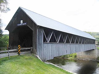
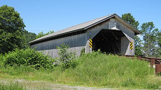
The Burt Henry Covered Bridge, also known as the Henry Covered Bridge or just the Henry Bridge, is a covered bridge that spans the Walloomsac River near Bennington, Vermont. A Town lattice truss bridge, it carries River Road, just south of the village of North Bennington. Originally built about 1840, it was listed on the National Register of Historic Places in 1973 as Bennington County's oldest covered bridge. It was rebuilt in 1989 by the Vermont Agency of Transportation.

The Mount Orne Bridge is a covered bridge over the Connecticut River between Lancaster, New Hampshire, and Lunenburg, Vermont. It joins Elm Street in South Lancaster with River Road in Lunenburg. Built in 1911, it is one of two Howe truss bridges across the Connecticut River. It was listed on the National Register of Historic Places in 1976.
The Scribner Covered Bridge, also known as the Mudgett Covered Bridge, is a covered bridge that carries Rocky Road across the Gihon River off State Route 100C in eastern Johnson, Vermont. It was listed on the National Register of Historic Places in 1974. It is one of a small number of Vermont's covered bridges that are the result of covering and existing open bridge.
The Gifford Covered Bridge, also called the C.K. Smith Covered Bridge, is a wooden covered bridge that crosses the Second Branch of the White River in Randolph, Vermont on Hyde Road. It was listed on the National Register of Historic Places in 1974. It is one of two bridges in the state that was uncovered when first built, its trusses boxed for shelter.

The Stony Brook Covered Bridge, also called the Moseley Covered Bridge, is a wooden covered bridge that crosses Stony Brook in Northfield, Vermont on Stony Brook Road. Built in 1899, it is one of two surviving 19th-century King post truss bridges in the state. It was listed on the National Register of Historic Places in 1974.
The Northfield Falls Covered Bridge, also called the Station Covered Bridge, is a wooden covered bridge that carries Cox Brook Road across the Dog River in Northfield, Vermont. Built in 1872, this Town lattice truss bridge is one of five surviving covered bridges in the town, and one of two that are visible from each other. It was listed on the National Register of Historic Places in 1974.
The Hopkins Covered Bridge is a wooden covered bridge that crosses the Trout River in Enosburg, Vermont on Hopkins Bridge Road. Built in 1875 by brothers Sheldon & Savannah Jewett, it is one of a cluster of area covered bridges all attributed to the same builders. It was listed on the National Register of Historic Places in 1974.

The Longley Covered Bridge, also known as the Harnois Covered Bridge, is a wooden covered bridge that crosses the Trout River in Montgomery, Vermont on Longley Bridge Road. Built in 1863, this Town lattice truss bridge is the oldest of a group of area bridges built by brothers Sheldon & Savannah Jewett. It was listed on the National Register of Historic Places in 1974. The bridge is closed to traffic, and has been bypassed by an adjacent temporary bridge.

The Mill Covered Bridge is a wooden covered bridge that crosses the North Branch Lamoille River on Back Road in Belvidere, Vermont. Built about 1890, it is one of two surviving covered bridges in the rural community. It was listed on the National Register of Historic Places in 1974.

The Bloomfield-Nulhegan River Route 102 Bridge is a historic bridge in Bloomfield, Vermont. It carries Vermont Route 102 over the Nulhegan River, near its mouth at the Connecticut River just south of Bloomfield Village. Built in 1937, it is a well-preserved example of a Pratt through truss, exhibiting then state-of-the-art engineering. It was listed on the National Register of Historic Places in 1991.

The Fisher Covered Railroad Bridge is a covered bridge in Wolcott, Vermont. Built in 1908, it originally carried the St. Johnsbury and Lamoille County Railroad over the Lamoille River. Now closed, it was the last covered bridge in Vermont to carry railroad traffic, and is a rare surviving example in the state of a double Town lattice truss. It was listed on the National Register of Historic Places in 1974.

The Cilley Covered Bridge is a historic 19th-century covered bridge, carrying Howe Lane across the First Branch White River a short way south of the village of Tunbridge, Vermont. Built in 1883, it is a fine example of a Kingspost truss structure, and is one of the town's five 19th-century covered bridges. It was listed on the National Register of Historic Places in 1974.
The Howe Covered Bridge is a historic covered bridge carrying Belknap Brook Road across the White River in Tunbridge, Vermont, just east of Vermont Route 110. Built in 1879, it is one of five surviving bridges in the town, one of the highest concentrations of covered bridges in the state. It was listed on the National Register of Historic Places in 1974.

The Larkin Covered Bridge is a historic covered bridge, carrying Larkin Road across the First Branch White River in northern Tunbridge, Vermont. Built in 1902, it is one of the last documented covered bridges to be built in Vermont during the historic period of bridge construction, and is one of five covered bridges in the town. It was listed on the National Register of Historic Places in 1974.

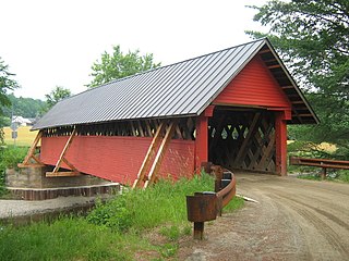
The Upper Falls Covered Bridge, also known as the Downers Covered Bridge, spans the Black River, carrying Upper Falls Road just south of Vermont Route 131 in western Weathersfield, Vermont. The Town lattice truss bridge was built in 1840 and rebuilt in 2008. Its gable ends are distinctive for their Greek Revival styling. The bridge was listed on the National Register of Historic Places in 1973.

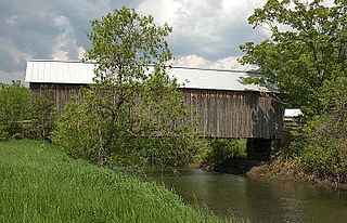
The East Shoreham Covered Railroad Bridge is a historic covered bridge spanning the Lemon Fair River near East Shoreham, Vermont. Built in 1897 by the Rutland Railroad Company, it is the state's only surviving example of a wooden Howe truss railroad bridge. It was listed on the National Register of Historic Places in 1974.

The Coburn Covered Bridge is a historic covered bridge, carrying Coburn Road over the Winooski River in eastern East Montpelier, Vermont. Built in 1851, it is the town's only surviving 19th-century covered bridge. It was listed on the National Register of Historic Places in 1974.

The Burrington Covered Bridge is a historic queenpost truss covered bridge in Lyndon, Vermont. Built in the 19th century, it is one of five covered bridges in Lyndon. It formerly carried Burrington Bridge Road across the Passumpsic River; it has been bypassed by a modern bridge. It was listed on the National Register of Historic Places in 1974.

The Jaynes Covered Bridge is a historic covered bridge, carrying Codding Hollow Road across the North Branch Lamoille River in Waterville, Vermont. Built in 1877, it is one of three 19th-century covered bridges in the town, and one of five to span the North Branch Lamoille in a five-mile span. It was listed on the National Register of Historic Places in 1974.
The River Road Covered Bridge is a historic covered bridge, carrying Veilleux Road across the Missisquoi River in Troy, Vermont. Built in 1910, the Town lattice truss is the only surviving covered bridge in Troy from the historic period of covered bridge construction. It also exhibits some distinctive variations in construction from more typical Town lattices. It was listed on the National Register of Historic Places in 1974.