
Gill is a town in Franklin County, Massachusetts, United States. The population was 1,500 at the 2010 census. It is part of the Springfield, Massachusetts Metropolitan Statistical Area. The campus of Northfield Mount Hermon School is located in the Mount Hermon section of the town.

Montague is a town in Franklin County, Massachusetts, United States. The population was 8,437 at the 2010 census. It is part of the Springfield, Massachusetts metropolitan statistical area.

Turners Falls is an unincorporated village and census-designated place in the town of Montague in Franklin County, Massachusetts, United States. The population was 4,470 at the 2010 census. It is part of the Springfield, Massachusetts Metropolitan Statistical Area. Its name is generally used as a metonym for the entire town of Montague.

The Tamar Bridge is a suspension bridge over the River Tamar between Saltash, Cornwall and Plymouth, Devon in southwest England. It is 335 metres (1,099 ft) long, running adjacent to the Royal Albert Bridge, and part of the A38, a main road between the two counties.

The Farmington River is a river, 46.7 miles (75.2 km) in length along its main stem, located in northwest Connecticut with major tributaries extending into southwest Massachusetts. The longest route of the river, from the origin of its West Branch, is 80.4 miles (129.4 km) long, making it the Connecticut River's longest tributary by 2.3 miles (3.7 km) over the major river directly to its north, the Westfield River. The Farmington River's watershed covers 609 square miles (1,580 km2). Historically, the river played an important role in small-scale manufacturing in towns along its course, but it is now mainly used for recreation and drinking water.

The Conwy Suspension Bridge is a Grade I-listed structure and is one of the first road suspension bridges in the world. Located in the medieval town of Conwy in Conwy county borough, North Wales, it is now only passable on foot. The bridge is now in the care of the National Trust. It originally carried the A55(T) road from Chester to Bangor.

The Niagara Falls Suspension Bridge stood from 1855 to 1897 across the Niagara River and was the world's first working railway suspension bridge. It spanned 825 feet (251 m) and stood 2.5 miles (4.0 km) downstream of Niagara Falls, where it connected Niagara Falls, Ontario to Niagara Falls, New York. Trains used the upper of its two decks, while pedestrians and carriages used the lower. The bridge was the idea of Canadian politicians, and it was built by an American company and a Canadian company. It was most commonly called the Suspension Bridge, although other names included Niagara Railway Suspension Bridge, Niagara Suspension Bridge, and its official American name of the International Suspension Bridge.

Route 63 is a 24.048-mile-long (38.702 km) state highway in Massachusetts, United States, running from Route 116 in Amherst north to the New Hampshire state line in Northfield, where it continues as New Hampshire Route 63. Along the way it intersects several major highways including Route 2 in Erving and Route 10 in Northfield.

The Turners Falls Canal, also historically known as the Montague Canal, was a canal along the Connecticut River in Montague, Massachusetts. It was reconstructed in 1869.

The Sunderland Bridge is a crossing over the Connecticut River in western Massachusetts, connecting the towns of South Deerfield and Sunderland, carrying Massachusetts Route 116.
The General Pierce Bridge is a steel truss road bridge over the Connecticut River between Greenfield, Massachusetts and Montague, Massachusetts carrying Montague City Road.

The Canalside Rail Trail Bridge is a former New York, New Haven and Hartford Railroad rail bridge across the Connecticut River between Deerfield and Montague, Massachusetts. The bridge is on the Massachusetts Historic Bridge Inventory as a "Historic Metal Truss Bridge", currently the sixth oldest metal truss bridge on the state-wide historic registry. The Canalside Rail Trail, completed in Spring 2008, incorporates this bridge.

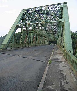
The Turners Falls Road Bridge is a concrete and steel road bridge over the Connecticut River in the U.S. state of Massachusetts. It carries Turners Falls Road and connects the town center of Greenfield and the village of Turners Falls.

The Washington Bridge, also known as the Devon Bridge, carries U.S. Route 1 (US 1) over the Housatonic River in the U.S. state of Connecticut, connecting the city of Milford to the town of Stratford. Its geographic location is N 41.20037 by W −73.11039. It is considered architecturally notable by the National Register of Historic Places for its five 100-foot-long (30 m) arches. It is designated Bridge No. 327 by the state Department of Transportation.

The Beebe Bridge is a two-lane, steel through arch bridge crossing the Columbia River at Chelan Falls, Washington. Located three miles east of Lake Chelan, the bridge is part of U.S. Route 97 and averages 5000 vehicle crossings per day.

The Bellows Falls Arch Bridge was a three-hinged steel through arch bridge over the Connecticut River between Bellows Falls, Vermont and North Walpole, New Hampshire. It was structurally significant as the longest arch bridge in the United States when it was completed in 1905.
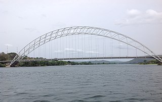
The Adomi Bridge is a latticed steel arch suspension bridge crossing the Volta River at Atimpoku in Ghana in West Africa. It is the first permanent bridge to span the Volta River, which drains south into the Gulf of Guinea, and is Ghana's longest suspension bridge. It provides the main road passage, just south of the Akosombo Dam, between the Eastern Region and the Volta Region of Ghana. It was opened in 1957 by Kwame Nkrumah, Ghana's first president. The iconic crescent-shaped arch bridge is featured in Ghanaian stamps and currency.
The Fall River is a 14.1-mile-long (22.7 km) river in southern Vermont and northern Massachusetts, joining the Connecticut River just downstream from Turners Falls, Massachusetts.

The Riverside Village Historic District encompasses a village community near Massachusetts Route 2 in Gill, Massachusetts. The district was listed on the National Register of Historic Places in 1992.


