The Boston Post Road was a system of mail-delivery routes between New York City and Boston, Massachusetts that evolved into one of the first major highways in the United States.

Interstate 91 (I-91) is an Interstate Highway in the New England region of the United States. It provides the primary north–south thoroughfare in the western part of the region. The Interstate generally follows the course of the Connecticut River. Its southern terminus is in New Haven, Connecticut, at Interstate 95. The northern terminus is in the village of Derby Line, Vermont, at the Canadian border. Past the Derby Line–Rock Island Border Crossing, the road continues as Quebec Autoroute 55. I-91 is the longest of three Interstate highways whose entire route is located within the New England states and is also the only primary (two-digit) Interstate Highway in New England to intersect all five of the other highways that run through the region. The largest cities along its route are New Haven, Connecticut; Hartford, Connecticut; Springfield, Massachusetts; Northampton, Massachusetts; Greenfield, Massachusetts; Brattleboro, Vermont; White River Junction, Vermont; and St. Johnsbury, Vermont in order from south to north.

Deerfield is a town in Franklin County, Massachusetts, United States. Settled near the Connecticut River in the 17th century during the colonial era, the population was 5,090 as of the 2020 census. Deerfield is part of the Springfield, Massachusetts Metropolitan Statistical Area in western Massachusetts, lying 30 miles (48 km) north of the city of Springfield.

Montague is a town in Franklin County, Massachusetts, United States. The population was 8,580 at the 2020 census. It is part of the Springfield, Massachusetts metropolitan statistical area.

U.S. Route 5 is a north–south United States highway running through the New England states of Connecticut, Massachusetts, and Vermont. Significant cities along the route include New Haven, Connecticut; Hartford, Connecticut; and Springfield, Massachusetts. From Hartford northward to St. Johnsbury, Vermont, the road closely follows the route of the Connecticut River.

New York State Route 22 (NY 22) is a north–south state highway that parallels the eastern border of the U.S. state of New York, from the outskirts of New York City to the hamlet of Mooers in Clinton County near the Canadian border. At 337 miles (542 km), it is the state's longest north–south route and the third longest state route overall, after NY 5 and NY 17. Many of the state's major east–west roads intersect with, and often join, NY 22 just before crossing into the neighboring New England states, where U.S. Route 7 (US 7), which originally partially followed NY 22's alignment, similarly parallels the New York state line.
U.S. Route 1A is the name of several highways found in the United States.

Route 28 is a 151.93-mile-long (244.51 km) nominally south–north state highway in the U.S. state of Massachusetts, running from the town of Eastham via Boston to the New Hampshire state line in Methuen. Following the route from its nominally southern end, Route 28 initially heads south to the town of Chatham then turns west to follow along the south shore of Cape Cod. In Falmouth, Route 28 turns north and continues through the western part of Plymouth County and the eastern part of Norfolk County; it then passes through downtown Boston before heading north via Lawrence to the New Hampshire state line, where it continues as New Hampshire Route 28.

Route 63 is a 24.048-mile-long (38.702 km) state highway in Massachusetts, United States, running from Route 116 in Amherst north to the New Hampshire state line in Northfield, where it continues as New Hampshire Route 63. Along the way it intersects several major highways including Route 2 in Erving and Route 10 in Northfield.

Massachusetts Route 7A is a state highway and alternate to U.S. Route 7 in Berkshire County, Massachusetts. It has two posted segments, with a total length of 5.83 miles (9.38 km). Between these segments, Route 7A is coextensive with US 7.

U.S. Route 1 (US 1) is a part of the U.S. Highway System that extends from Key West, Florida, to the Canada–United States border at Fort Kent, Maine. In the U.S. state of New York, US 1 extends 21.54 miles (34.67 km) from the George Washington Bridge in Manhattan to the Connecticut state line at Port Chester. It closely parallels Interstate 95 (I-95) for much of its course, and does not serve as a major trunk road within the state. It is not concurrent with any other highways besides I-95 and (briefly) US 9, and few other state highways intersect it.
U.S. Route 5 (US 5), a north–south U.S. Highway that is generally paralleled by Interstate 91 (I-91), begins at the city of New Haven in Connecticut and heads north through western Massachusetts and eastern Vermont to the international border with Canada. Within Connecticut, US 5 proceeds north from New Haven and passes through Meriden and Hartford towards Springfield, Massachusetts.

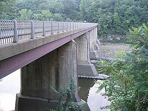
The Canalside Rail Trail Bridge is a former New York, New Haven and Hartford Railroad rail bridge across the Connecticut River between Deerfield and Montague, Massachusetts. The bridge is on the Massachusetts Historic Bridge Inventory as a "Historic Metal Truss Bridge", currently the sixth oldest metal truss bridge on the state-wide historic registry. The Canalside Rail Trail, completed in Spring 2008, incorporates this bridge.
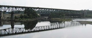
The Turners Falls–Gill Bridge, is a steel deck truss bridge crossing the Connecticut River in Massachusetts. It connects the Town of Gill with the village of Turners Falls in the Town of Montague. The bridge carries automobile and pedestrian traffic.

Route 190 is a state route in the northern part of the U.S. state of Connecticut. It starts at Route 75 in the town of Suffield and proceeds eastward across the Connecticut River through the towns of Enfield, Somers, and Stafford. It ends at Route 171, in the town of Union. Route 190 was established in 1932 as a route between the state line at Southwick and the town of Enfield. The route was later extended eastward to Union but was truncated in the west to Suffield center.

Maryland Route 191 is a state highway in the U.S. state of Maryland. Known for most of its length as Bradley Boulevard, the highway runs 7.16 miles (11.52 km) from MD 190 in Potomac east to MD 185 in Chevy Chase. MD 191 serves an affluent area with many golf courses as it connects Potomac and Chevy Chase by way of an S-shaped path through Bethesda in southwestern Montgomery County. Bradley Lane, the name for the Chevy Chase portion of the highway, was paved by 1910. This included the segment of the lane between MD 185 and MD 186, which was removed from the state highway in the 1940s. The remainder of MD 191 was constructed along mostly new alignment through Bethesda and Potomac in the early 1920s. The highway originally continued beyond its present western terminus and looped south along Persimmon Tree Road to Cabin John. MD 191 was expanded to a divided highway between what is now MD 355 and MD 614 in two portions in the 1940s and 1960s. The highway was relocated at its Persimmon Tree Road crossing of Interstate 495 (I-495) when the freeway was built in the early 1960s. The Cabin John–Potomac portion of MD 191 was removed from the state highway system in 1999.
The Franklin Regional Transit Authority (FRTA) is a regional transit authority which provides public transportation principally to Franklin County and the North Quabbin region, both in Massachusetts. The FRTA is based in the county seat of Greenfield, Massachusetts.

The Fall River is a 14.1-mile-long (22.7 km) river in southern Vermont and northern Massachusetts, joining the Connecticut River just downstream from Turners Falls, Massachusetts.
The Riverside Village Historic District encompasses a village community near Massachusetts Route 2 in Gill, Massachusetts. The district was listed on the National Register of Historic Places in 1992.

U.S. Route 44 (US 44) is an east–west United States Numbered Highway that runs for 237 miles (381 km) through four states in the Northeastern United States. The western terminus is at US 209 and New York State Route 55 (NY 55) in Kerhonkson, New York, a hamlet in the Hudson Valley region. The eastern terminus is at Route 3A in Plymouth, Massachusetts.