Bigelow Brook

Last updated
Bigelow Brook
BigelowBrook-1.jpg
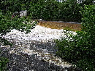
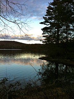
Bigelow Brook in Eastford, CT, along the Natchaug Trail.
Relief map USA Connecticut.png
Red pog.svg
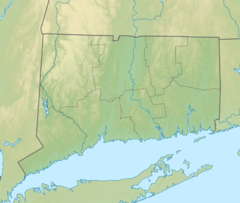
Location of the mouth within Connecticut
Location
CountryUnited States
State Connecticut
Counties Tolland, Windham
Physical characteristics
Source Mashapaug Lake
 - location Union, CT, Tolland County, Connecticut, United States
 - coordinates 42°00′19″N72°07′43″W / 42.00524°N 72.12868°W / 42.00524; -72.12868
 - elevation705 ft (215 m)
Mouth Confluence with Still River
 - location
Eastford, Connecticut, Windham County, Connecticut, United States
 - coordinates
41°51′51″N72°05′24″W / 41.86403°N 72.09010°W / 41.86403; -72.09010 Coordinates: 41°51′51″N72°05′24″W / 41.86403°N 72.09010°W / 41.86403; -72.09010
 - elevation
420 ft (130 m)approx.

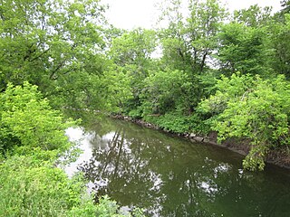
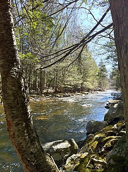
Bigelow Brook is a river in northeastern Connecticut, flowing from Mashapaug Lake in Union to its confluence with the Still River in Eastford.

Connecticut state of the United States of America

Connecticut is the southernmost state in the New England region of the United States. As of the 2010 Census, it has the highest per-capita income, Human Development Index (0.962), and median household income in the United States. It is bordered by Rhode Island to the east, Massachusetts to the north, New York to the west, and Long Island Sound to the south. Its capital is Hartford and its most populous city is Bridgeport. It is part of New England, although portions of it are often grouped with New York and New Jersey as the Tri-state area. The state is named for the Connecticut River which approximately bisects the state. The word "Connecticut" is derived from various anglicized spellings of an Algonquian word for "long tidal river".

Mashapaug Lake lake of the United States of America

Mashapaug Lake is a 297-acre (1.20 km2) lake surrounded by Bigelow Hollow State Park and Nipmuck State Forest in the town of Union in northeastern Connecticut. The lake has a maximum depth of 39.5 feet, and an average depth of 15 feet. Its normal surface elevation is 706 feet. The lake is very popular with fishermen and boaters from the area, and can also be used for swimming.

Union, Connecticut Town in Connecticut, United States

Union is a town located in the northeastern part of Tolland County, Connecticut, United States and is part of the Quinebaug and Shetucket Rivers Valley National Heritage Corridor. The population was 854 at the 2010 census, making it the least populous town and municipality in Connecticut. Union includes the village of Mashapaug located in the Eastern Uplands at the Massachusetts state line. Also, Union is located 33 miles northeast of the state capital, Hartford and 67 mi (108 km) southwest of Boston as well as 153 mi (246 km) northeast of New York City.

Contents

Bigelow Brook is formed in Union, Connecticut at the outflow of Mashapaug Lake. After leaving the lake, it flows south through the Bigelow Hollow State Park in Union, and into Bigelow Pond. After exiting Bigelow Pond, the brook flows to the southwest and then into Myers Pond. After flowing out of Myers Pond, Bigelow Brook begins flowing to the south. It then leaves Union and serves as the border between the towns of Ashford, Connecticut, and Eastford, Connecticut. The brook then changes direction and starts flowing to the east, into the town of Eastford. It turns again shortly after, back to the south, and continues on a generally southerly or south-southeasterly path through Eastford. Bigelow Brook eventually ends at its confluence with the Still River, forming the Natchaug River. [1]

Bigelow Hollow State Park

Bigelow Hollow State Park is public recreation area in the town of Union, Connecticut, in the Quinebaug Highlands. The state park's 516 acres (209 ha) border Nipmuck State Forest on the east and west and Mashapaug Lake on the north. The park and forest are located in a large hollow or depression approximately 700' below the surrounding ridgelines. They are managed by the Connecticut Department of Energy and Environmental Protection.

Ashford, Connecticut Town in Connecticut, United States

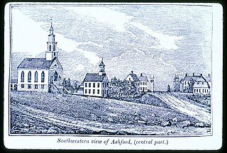
Ashford is a town in Windham County, Connecticut, United States. It is part of the Connecticut Quiet Corner. The population was 4,317 at the 2010 census. It was founded in 1714. Eastford was a part of Ashford until 1847, when the former split off to organize its own town. For this reason North Ashford is located in northeast Eastford.

Eastford, Connecticut Town in Connecticut, United States

Eastford is a town in Windham County, Connecticut, United States. The population was 1,618 at the 2000 census.

Bigelow Brook is popular with fishermen from the area. Trout are one type of fish that swim in its waters.

Trout Number of species of freshwater fish

Trout is the common name for a number of species of freshwater fish belonging to the genera Oncorhynchus, Salmo and Salvelinus, all of the subfamily Salmoninae of the family Salmonidae. The word trout is also used as part of the name of some non-salmonid fish such as Cynoscion nebulosus, the spotted seatrout or speckled trout.

Tributaries

Tributaries of Bigelow Brook include (from north to south) Gulf Brook, Bush Meadow Brook, Lead Mine Brook, Branch Brook, Warren Brook, Walker Brook, and Stones Brook. [2]

See also

Related Research Articles

Housatonic River river in the United States of America

The Housatonic River is a river, approximately 149 miles (240 km) long, in western Massachusetts and western Connecticut in the United States. It flows south to southeast, and drains about 1,950 square miles (5,100 km2) of southwestern Connecticut into Long Island Sound. Its watershed is just to the west of the watershed of the lower Connecticut River. Birds and fish who live in and around the river contain significant levels of PCBs and present health risks.

Mascoma River river in the United States of America

The Mascoma River is a 31.6-mile-long (50.9 km) river located in western New Hampshire in the United States. It is a tributary of the Connecticut River, which flows to Long Island Sound. The Mascoma comprises two sections which are split by Mascoma Lake in the communities of Enfield and Lebanon. Counting the lake would add 2.7 miles (4.3 km) to the river's length.

Carrabassett River river in the United States of America

The Carrabassett River, a tributary of the Kennebec River, is located in Franklin County and Somerset County, Maine, in the United States. It rises near Sugarloaf Mountain, east of Rangeley Lake, and runs for 33.8 miles (54.4 km), flowing southeast past Kingfield and joining the Kennebec River in the town of Anson.

Quinebaug River river in the United States of America

The Quinebaug River is a river in south-central Massachusetts and eastern Connecticut, with watershed extending into western Rhode Island. The name "Quinebaug" comes from the southern New England Native American term, spelled variously Qunnubbâgge, Quinibauge, etc., meaning "long pond", from qunni-, "long", and -paug, "pond". The river is one of the namesake rivers in the Quinebaug and Shetucket Rivers Valley National Heritage Corridor.

Mount Hope River river in the United States of America

The Mount Hope River is a river in northeastern section of the U.S. state of Connecticut. The river is formed at the outlet of Morey Pond at the extreme northern end of Ashford, Connecticut, at the border of Union, Connecticut, and flows about 15 miles (24 km) south to Mansfield Hollow Lake, just south of Mansfield, Connecticut.

Passumpsic River river in the United States of America

The Passumpsic River is a 22.7-mile-long (36.5 km) tributary of the Connecticut River, in Vermont. Though primarily a Caledonia County river, it is the only river to flow through all three counties of the Northeast Kingdom.

Molly Ann Brook river in the United States of America

Molly Ann Brook is a tributary of the Passaic River which flows south between the northern ranges of First Watchung Mountain and Second Watchung Mountain in Passaic County and Bergen County, New Jersey. Traveling north from its confluence with the Passaic River, Molly Ann Brook passes through the city of Paterson and the boroughs of Haledon, Prospect Park, North Haledon and Franklin Lakes.

Slippery Rock Brook river in the United States of America

Slippery Rock Brook is a tributary of the Passaic River in Passaic County, New Jersey in the United States.

Last Green Valley National Heritage Corridor

The Last Green Valley National Heritage Corridor is in northeastern Connecticut and portions of Massachusetts. It has a rural character with rolling hills, farmland and classic New England scenery. This area was designated because it is one of the last remaining stretches of green in the Boston to Washington, D.C. heavily urbanized corridor. The valley also has the largest stretch of dark night sky in the Boston-D.C. corridor. It contains some of the largest unbroken forests in Southern New England, in a region of Connecticut known as the Quiet Corner.

Fish River (Maine)

The Fish River is a 69.9-mile-long (112.5 km) river in northern Maine in the United States. It is a tributary of the Saint John River, which flows to the Bay of Fundy in New Brunswick, Canada.

The Sebec River is a tributary of the Piscataquis River in Piscataquis County, Maine. From the outflow of Sebec Lake in Sebec, the river runs 10.0 miles (16.1 km) east and southeast to its confluence with the Piscataquis in Milo.

Natchaug River river in the United States of America

The Natchaug River is a 17.9-mile-long (28.8 km) river in Windham and Tolland Counties in northeastern Connecticut.

Natchaug Trail

The Natchaug Trail is a Blue-Blazed hiking trail "system" which meanders through 19.5 miles (31.4 km) of forests in northeast Connecticut—primarily in Windham County. It is maintained by the Connecticut Forest and Park Association. Its southern trailhead begins in the James L. Goodwin State Forest in the towns of Chaplin, Connecticut and Hampton, Connecticut and the northern terminus is at its intersection with the Nipmuck Trail in Natchaug State Forest in Eastford, Connecticut.

Cadoxton River short river in the United Kingdom

The Cadoxton River is a short river in the Vale of Glamorgan, South Wales and with a length of about 5 miles/8 kilometres it is one of Wales's shortest rivers.

Ashford Lake

Ashford Lake is a small, shallow, privately owned pond located in the eastern part of the town of Ashford in northeastern Connecticut, along the town's border with Eastford. The pond has an area of 52.6 acres and a maximum depth of approximately 12 feet. Its normal surface elevation is 659 feet above sea level.

Sheldrake River river in the United States of America

The Sheldrake River is a freshwater stream located in Southern Westchester County, New York. The river forms in White Plains and flows six miles (9.7 km) south until it joins the Mamaroneck River. Approximately 1.58 miles (2.54 km) of the Sheldrake River flow through Scarsdale, 2.13 miles (3.43 km) through New Rochelle and two miles (3.2 km) through the Town of Mamaroneck.

References