
The Boston Post Road was a system of mail-delivery routes between New York City and Boston, Massachusetts, that evolved into one of the first major highways in the United States.

Fairfield County is a county in the southwestern corner of the U.S. state of Connecticut. It is the most populous county in the state and was also its fastest-growing from 2010 to 2020. As of the 2020 census, the county's population was 957,419, representing 26.6% of Connecticut's overall population. The closest to the center of the New York metropolitan area, the county contains four of the state's seven largest cities—Bridgeport (first), Stamford (second), Norwalk (sixth) and Danbury (seventh)—whose combined population of 433,368 is nearly half the county's total population.

New Haven County is a county in the south central part of the U.S. state of Connecticut. As of the 2020 census, the population was 864,835, making it the third-most populous county in Connecticut. Two of the state's five largest cities, New Haven (3rd) and Waterbury (5th), are part of New Haven County.
Milford is a city in Kent and Sussex counties in the U.S. state of Delaware. According to the 2020 census, the population of the city is 11,190 people and 4,356 households in the city.

Monson is a town in Hampden County, Massachusetts, United States. The population was 8,150 at the 2020 census. It is part of the Springfield, Massachusetts Metropolitan Statistical Area.

Milford is a coastal city in New Haven County, Connecticut, United States, between New Haven and Bridgeport. The population was 50,558 at the 2020 United States Census. The city includes the village of Devon and the borough of Woodmont. Milford is part of the South Central Connecticut Planning Region and New York metropolitan area.

Orange is a town in New Haven County, Connecticut, United States. The town is part of the South Central Connecticut Planning Region. The population was 14,280 at the 2020 census. The town is governed by a Board of Selectmen.

West Haven is a city in New Haven County, Connecticut, United States, located on the coast of Long Island Sound. The city is part of the South Central Connecticut Planning Region. At the 2020 census, the population of the city was 55,584.

Ware is a town in Hampshire County, Massachusetts, United States. The population was 10,066 as of 2020. It is part of the Springfield, Massachusetts Metropolitan Statistical Area.

The Housatonic River is a river, approximately 149 miles (240 km) long, in western Massachusetts and western Connecticut in the United States. It flows south to southeast, and drains about 1,950 square miles (5,100 km2) of southwestern Connecticut into Long Island Sound.

New Milford is a town in Litchfield County, Connecticut, United States. The town, part of Greater Danbury, as well as the New York Metropolitan Area, has a population of 28,115 as of the 2020 census. New Milford lies 14 miles (23 km) north of Danbury on the banks of the Housatonic River, and shares its border with the northeastern shore of Candlewood Lake. It is the largest town in the state of Connecticut in terms of land area at nearly 63.7 mi2 (164.9822 km2). The town center is listed as a census-designated place (CDP).

The Farmington River is a river, 46.7 miles (75.2 km) in length along its main stem, located in northwest Connecticut with major tributaries extending into southwest Massachusetts. The longest route of the river, from the origin of its West Branch, is 80.4 miles (129.4 km) long, making it the Connecticut River's longest tributary by 2.3 miles (3.7 km) over the Westfield River directly to its north. The Farmington River's watershed covers 609 square miles (1,580 km2). Historically, the river played an important role in small-scale manufacturing in towns along its course, but it is now mainly used for recreation and drinking water.

Route 15 is a state highway in the U.S. state of Connecticut that runs 83.53 miles (134.43 km) from a connection with New York's Hutchinson River Parkway in Greenwich, Connecticut, to its northern terminus intersecting with Interstate 84 (I-84) in East Hartford, Connecticut. Route 15 consists of four distinct sections: the Merritt Parkway, the Wilbur Cross Parkway, most of the Berlin Turnpike, and part of the Wilbur Cross Highway. The unified designation was applied to these separate highways in 1948 to provide a continuous through route from New York to Massachusetts. The parkway section of Route 15 is often referred to locally as "The Merritt".

Quassaick Creek is an 18.4-mile-long (29.6 km) tributary of the Hudson River in Orange and Ulster counties in the U.S. state of New York. It rises in the glacial ridges west of the river, near the boundary between the towns of Plattekill and Marlborough. From there it flows south into the town of Newburgh and then the city, where it eventually forms part of the border between it and neighboring New Windsor before emptying into the Hudson.

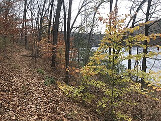
The Housatonic Range Trail is a 6.2-mile (10.0 km) Blue-Blazed hiking trail on Candlewood Mountain in the town of New Milford. The north-south axis of the trail parallels the Housatonic River through private land and land trust parcels. The Housatonic Range Trail is maintained largely through the efforts of the Connecticut Forest and Park Association, which provides online Blue Trail maps.

The Zoar Trail is a 6.5-mile (10.5 km) Blue-Blazed hiking trail "system" in the lower Housatonic River valley in Fairfield County, Connecticut and is entirely in the Sandy Hook section of Newtown in the lower block of Paugussett State Forest.
The Kettletown Trails are a 4.6-mile (7.4 km) Blue-Blazed hiking trail "system" in the lower Housatonic River valley in Fairfield County and are in the towns of Southbury and Oxford -- primarily in the Kettletown State Park and the Jackson Cove recreation area belonging to the town of Oxford.

The South Central Connecticut Regional WaterAuthority is a public water supply utility in Connecticut, United States. The RWA supplies water in a 15-town region with a population of about 430,000. The RWA acts as a steward of the environment in the local region by protecting more than 26,000 acres of watershed lands, and promoting sustainability.
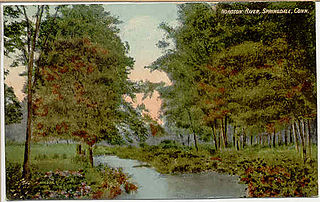
The Noroton River is a 9.4-mile-long (15.1 km) stream which forms most of the border between Stamford and Darien, Connecticut, United States. The river's headwaters are in New Canaan, Connecticut and flow into Holly Pond. It is the largest flowing body of water between the Mill River/Rippowam River to the west and the Fivemile River to the east, although Stony Brook and the Goodwives River in Darien are not much smaller.

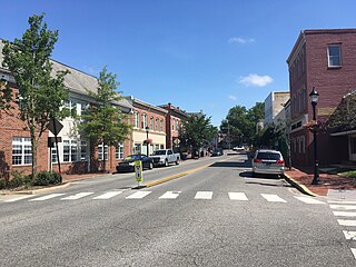
The River Park Historic District encompasses the residential and civic heart of the city of Milford, Connecticut. Stretching along both sides of the Wepawaug River, the area includes part of Milford's earliest colonial settlement, and a series of parks that resulted from an early 20th-century beautification project. The district was listed on the National Register of Historic Places in 1986.


