Colchester (CDP), Connecticut

Last updated

Colchester, Connecticut
Main Street, Colchester CT.jpg
Main Street
USA Connecticut location map.svg
Red pog.svg
Colchester
Usa edcp location map.svg
Red pog.svg
Colchester
Coordinates: 41°34′34″N72°19′57″W / 41.57611°N 72.33250°W / 41.57611; -72.33250
Country Flag of the United States.svg  United States
State Connecticut
County New London
Town Colchester
Area
[1]
  Total11.58 km2 (4.47 sq mi)
  Land11.58 km2 (4.47 sq mi)
  Water0.0 km2 (0.0 sq mi)
Elevation
[2]
141 m (463 ft)
Population
 (2010) [3]
  Total4,781
  Density413.0/km2 (1,070/sq mi)
Time zone UTC-5 (Eastern (EST))
  Summer (DST) UTC-4 (EDT)
ZIP Code
06415
Area code(s) 860/959
FIPS code 09-15840
GNIS feature ID2378348 [2]

Colchester is a census-designated place (CDP) comprising the primary village and adjacent residential land in the town of Colchester, New London County, Connecticut, United States. It is in the east-central part of the town, with the Connecticut Route 2 expressway running through the south side of the community. As of the 2010 census, the CDP had a population of 4,781, [3] out of 16,068 in the entire town of Colchester.

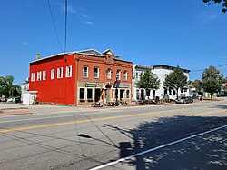
75 acres (30 ha) at the center of the village comprise the Colchester Village Historic District, listed on the National Register of Historic Places in 1994.

Related Research Articles

Clinton is a census-designated place (CDP) comprising the primary village in the town of Clinton, Middlesex County, Connecticut, United States. It is in the southwest corner of the town, bordered to the west, across the Hammonasset River, by the town of Madison in New Haven County, to the north by Interstate 95, and to the south by Clinton Harbor, an inlet of Long Island Sound. As of the 2020 census, the CDP had a population of 3,441, out of 13,185 in the entire town of Clinton.

<span class="mw-page-title-main">Durham (CDP), Connecticut</span> Census-designated place in Connecticut, United States

Durham is a census-designated place (CDP) comprising the primary village and surrounding development in the town of Durham, Middlesex County, Connecticut, United States. It is in the central and northeastern portions of the town, bordered to the north by the town of Middlefield and the city of Middletown. As of the 2020 census, the CDP had a population of 3,771, out of 7,152 in the entire town of Durham.

<span class="mw-page-title-main">East Hampton (CDP), Connecticut</span> Census-designated place in Connecticut, United States

East Hampton is a census-designated place (CDP) comprising the primary village and adjacent residential and rural land in the town of East Hampton, Middlesex County, Connecticut, United States. It is in the central and eastern portions of the town, bordered to the north by the East Hampton community of Lake Pocotopaug and to the east by the town of Colchester in New London County and the town of Marlborough in Hartford County. As of the 2020 census, the East Hampton CDP had a population of 2,960, out of 12,717 in the entire town of East Hampton.

Mashantucket is a census-designated place (CDP) in the northeast part of the town of Ledyard, New London County, Connecticut, United States. It consists of land held by the Mashantucket Pequot Tribe. The Foxwoods Resort Casino is in the northeast part of the CDP, along Connecticut Route 2. As of the 2010 census, the CDP had a population of 299.

<span class="mw-page-title-main">Riverton, Connecticut</span> Census-designated place in Connecticut, United States

Riverton is an unincorporated village and census-designated place (CDP) in the town of Barkhamsted, Litchfield County, Connecticut, United States. It is in the northwest corner of the town, bordered to the north by the town of Hartland in Hartford County. The village sits at the confluence of the Still River with the West Branch of the Farmington River.

South Londonderry is an unincorporated village and census-designated place (CDP) in the town of Londonderry, Windham County, Vermont, United States. As of the 2020 census, it had a population of 147. The center of the village comprises the South Londonderry Village Historic District.

Northford is a census-designated place (CDP) comprising the primary village and surrounding residential and rural land in the town of North Branford, New Haven County, Connecticut, United States. It is in the northern part of the town, bordered to the west by the town of North Haven, to the east by the town of Guilford, and to the north by the town of Wallingford, all in New Haven County. It is bordered to the northeast by the town of Durham in Middlesex County. In 2002, 230 acres (93 ha) of the central village of Northford were designated as the Northford Center Historic District.

Cheshire Village is a census-designated place (CDP) comprising the primary village and adjacent residential land in the town of Cheshire, New Haven County, Connecticut, United States. It is in the center of the town, surrounding the intersections of Connecticut Routes 10, 70, and 68.

Madison Center is a census-designated place (CDP) comprising the primary village and surrounding residential land in the town of Madison, New Haven County, Connecticut, United States. It is in the southern part of the town, surrounding the intersection of U.S. Route 1 with Connecticut Route 79. The CDP extends south to Long Island Sound, north to Interstate 95, east to Fence Creek, and west to Long Shore Land and Stony Lane.

<span class="mw-page-title-main">Wallingford Center, Connecticut</span> Census-designated place in Connecticut, United States

Wallingford Center is a census-designated place (CDP) comprising the primary community in the town of Wallingford, New Haven County, Connecticut, United States. It is in the central and southern parts of the town, bordered to the west by the Wilbur Cross Parkway, to the east by Interstate 91, and to the south by the town of North Haven. To the north the CDP extends to New Rock Hill Road, Durham Road, Christian Street, North Elm Street, Maplewood Avenue, and up North Main Street as far as Yale Avenue, where it crosses the Wilbur Cross Parkway. U.S. Route 5 is the main north–south road through the community. To the north is the neighborhood of Yalesville.

Westbrook Center is a census-designated place (CDP) comprising the primary village and adjacent residential land in the town of Westbrook, Middlesex County, Connecticut, United States. It is in the southern part of the town, along U.S. Route 1 and bordered to the south by Long Island Sound. To the east it is bordered by the town of Old Saybrook, and the west and northwest border of the CDP is the Patchogue River. As of the 2020 census, the CDP had a population of 2,220, out of 6,769 in the entire town of Westbrook.

Redding Center is a census-designated place (CDP) in the town of Redding, Fairfield County, Connecticut, United States, comprising the central village in the town. Connecticut Route 107 passes through the community, leading north toward Bethel and southwest toward Georgetown. The Redding Center Historic District is at the center of the CDP, around the intersections of Cross Highway, Sanfordtown Road, Lonetown Road, and Hill Road.

Waterford is a census-designated place (CDP) comprising the primary village in the town of Waterford, New London County, Connecticut, United States. It is in the southeast part of the town, bordered to the east by the city of New London. U.S. Route 1 passes east–west through the community. As of the 2010 census, the CDP had a population of 2,887, out of 19,517 in the entire town of Waterford.

Brooklyn is a census-designated place (CDP) comprising the central unincorporated village in the town of Brooklyn in Windham County, Connecticut, United States. U.S. Route 6 passes through the center of the village, leading east to Danielson and west to Willimantic. As of the 2010 census, the population of the CDP was 981, out of 8,210 in the entire town of Brooklyn.

<span class="mw-page-title-main">Canaan (village), Connecticut</span> United States historic place

Canaan is a village and census-designated place (CDP) within the town of North Canaan in Litchfield County, Connecticut, United States. Formerly known as Canaan Depot, the village is more commonly known as Canaan Village to distinguish it from the town of Canaan located to the south of North Canaan. The Canaan Village Historic District is listed on the National Register of Historic Places. As of the 2010 census, the CDP had a population of 1,212, out of a total population of 3,315 in the town of North Canaan.

Westport Village is a census-designated place (CDP) in the town of Westport, Fairfield County, Connecticut, United States. It comprises the town center of Westport.

Sherman is a census-designated place (CDP) comprising the central community in the town of Sherman, Fairfield County, Connecticut, United States. It is in the central part of the town, at the north end of Candlewood Lake. The Sherman Historic District covers 85 acres (34 ha) in the northern part of the CDP, at the intersection of Connecticut Routes 37 and 39, containing many of the oldest buildings in the town.

Somers is a census-designated place (CDP) comprising the primary village in the town of Somers, Tolland County, Connecticut. As of the 2020 United States census, the Somers CDP had a population of 1,990, out of 10,255 in the town of Somers.

Whitingham is the central village and a census-designated place (CDP) in the town of Whitingham, Windham County, Vermont, United States. As of the 2020 census, it had a population of 91, compared to 1,344 in the entire town. Part of the village comprises the Whitingham Village Historic District.

References

  1. "2020 U.S. Gazetteer Files – Connecticut". United States Census Bureau. Retrieved April 15, 2021.
  2. 1 2 "Colchester Census Designated Place". Geographic Names Information System . United States Geological Survey, United States Department of the Interior.
  3. 1 2 "Total Population: 2010 Census DEC Summary File 1 (P1), Colchester CDP, Connecticut". data.census.gov. U.S. Census Bureau. Retrieved April 15, 2021.